Tornadoes, damaging wind, flooding reported as dangerous storms rip through South
Tornado Watches have been issued for parts of the South as a line of severe storms tracks eastward on Friday.
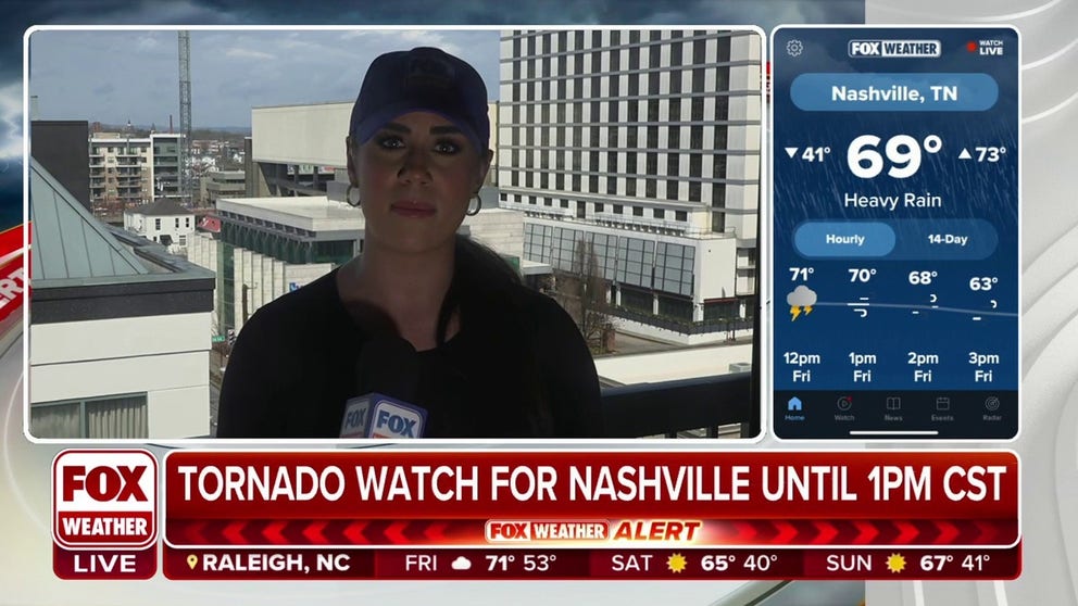
Nashville residents brace for severe weather
Fox News Multimedia Journalist Madison Scarpino speaks with residents of Nashville about how they are preparing for the upcoming severe weather.
The FOX Forecast Center continues to track the threat of severe storms moving across parts of the Southeast and into the Tennessee and Ohio valleys, where damaging winds, tornadoes and flash flooding are all significant threats on Friday.
The severe weather outbreak has killed at least five people during the multiday event. A 76-mph wind gust was reported in Dallas and more than 300,000 power outages were reported in Texas. NOAA's Storm Prediction Center received at least six tornado reports from northeastern Texas to northwestern Louisiana and more than 100 reports of damaging winds or wind damage from Central Texas to northern Louisiana and central Arkansas. Click here to see the full extent of damage caused by Thursday's severe weather outbreak.
DRONE CAPTURES TORNADO FORM AND ROLL ACROSS TEXAS IN DANGEROUS SEVERE WEATHER OUTBREAK

See the tornadoes, hurricane-force winds from the first severe weather outbreak of meteorological spring
The first storm system of meteorological spring produced tornadoes, hail and hurricane-force winds across at least three southern states.
Where are the storms now?
Showers and thunderstorms are ongoing from the Southeast to parts of the Ohio Valley, prompting several Flash Flood Warnings across Arkansas, southeastern Missouri, southern Illinois, southern Indiana and western Kentucky.
Damage was reported in Grant and Pike counties in Arkansas early Friday morning as a line of severe storms moved eastward across the state. In the town of Kirby, Arkansas, an emergency manager reported that 20 to 30 homes were damaged or destroyed. Some minor injuries were reported in the area.
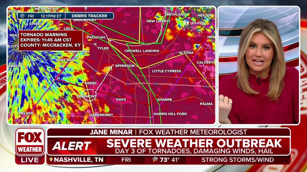
Fast-moving, radar-indicated tornado crossing Kentucky
The FOX Forecast Center is tracking a fast moving tornado that is currently crossing Kentucky.
The National Weather Service confirmed a tornado was in progress southeast of Paducah, Kentucky, just before noon Friday.

(FOX Weather)
WHY TORNADO VALLEY IS SHIFTING EAST
Friday's impact zone
The FOX Forecast Center expects the threat of severe storms to reenergize as a cold front advances eastward with the addition of daytime heating.
Damaging wind gusts and a few tornadoes are expected to be the primary concerns with Friday's storms as they fire up parts of the Southeast and into the Tennessee and Ohio valleys.
Cities under the threat of severe weather on Friday include Cincinnati, Louisville in Kentucky, Charleston in West Virginia, Nashville in Tennessee, Birmingham in Alabama and Atlanta.
MARCH BEGINS THE UPTICK IN SPRING TORNADOES ACROSS U.S.

(FOX Weather)
Storms also pose dangerous risk of flash flooding
A serious threat of flash flooding will also continue as some areas in the South see several rounds of rain through Friday.
Computer forecast models show parts of northeastern Arkansas, southeastern Missouri, western Kentucky, southern Illinois and southern Indiana could pick up to 3 inches of rainfall through Friday, with isolated areas seeing substantially more.
Where thunderstorms stall or repeatedly track over the same areas, rivers and streams could quickly rise, especially in communities near waterways that are already considered to be at full bank.
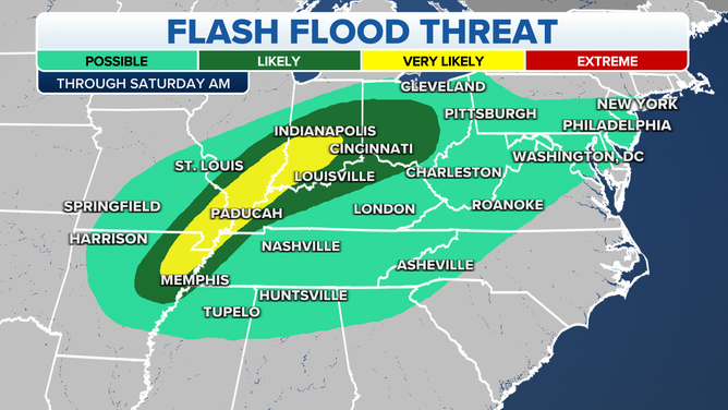
Here's a look at the flash flood threat for Friday, March 3, 2023.
(FOX Weather)