Winter storm system begins assault on southern US with snow, heavy rain and severe storms
Heavy rainfall fell along the Gulf Coast through Friday

Snow spreads east Friday across central Plains ahead of weekend nor'easter
After producing up to 18 inches of snow in the Southwest, the storm is currently dropping snow across the central Plains. It is expected to spread east through the day, reaching Missouri Friday afternoon.
Before blasting the Northeast with snow this weekend, a developing nor'easter is bringing snow, soaking rain and severe weather to the South on Friday, as a second system lurks on its heels early next week.
The storm system was roughly split down the middle with its northern half delivering snow to Arkansas, Kansas, Oklahoma and Missouri, while its southern half consisted of thunderstorms dumping heavy rainfall across the Gulf Coast with even a threat of severe weather into the weekend.

(FOX Weather)
About 1-3 inches of snow was reported across northwestern Arkansas on Friday, with about an inch or so in eastern Oklahoma and a few inches in southern Kansas.
The wintry weather led to slick roads across the region and several crashes across Arkansas. Transportation officials reported a significant crash led to all northbound lanes south of Fayetteville to be closed for an extended period.
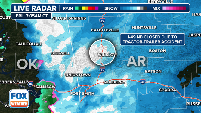
Radar image of snow in Arkansas Friday morning where a crash occurred on Interstate 49.
Light to moderate snow was also falling in southern Kansas with generally 1-2 inches likely, though the area around Harper may see as much as 3-5 inches and Wichita may get up to 2-4 inches.
Snow plows were hard at work at Wichita's airport keeping runways clear as snow fell through the morning. So far, airport operations around the country were seemingly not impacted by Friday's round of wet weather, as most flights were on-time.

Crews work to clear runways at Wichita airport
Crews worked to clear the airfield at Wichita Dwight D Eisenhower National Airport – ICT on Friday as a winter storm brought several inches of snow to Kansas.
Heavy rain, severe storms possible along the Gulf Coast
On the warmer, southern side of the storm, it's heavy rains and severe weather that are the primary threat.
Heavy rains poured across eastern Texas Friday morning making for a wet Houston commute, but have since pushed east into Louisiana and southern Arkansas. A couple of inches of rain is possible in some areas through Saturday, especially along the Gulf Coast.

(FOX Weather)
"With more mild air, they're going to have a higher chance of severe thunderstorms," FOX Weather Meteorologist Britta Merwin said. "It's going to be locked up across the Gulf states."
In Texas, Governor Greg Abbott ordered the Texas Division of Emergency Management to activate emergency response resources like plow crews, warming centers, swiftwater boat rescue crews, disaster assessment and recovery agents and set up communication with utility companies.
"Multiple weather threats are expected to impact large areas of Texas over the next several days. Snow is forecast across the Texas Panhandle with potential to cause hazardous travel conditions," stated the governor's press release. "Additionally, heavy rainfall and flash flooding threaten the Texas Gulf Coast and East Texas over the course of the next week. That rain may trigger river flooding through the weekend. Severe thunderstorms are a possibility in Southeast Texas at the start of next week."
On Saturday, isolated strong to severe thunderstorms are possible across parts of Florida and southern Georgia.

(FOX Weather)
Another storm hot on its heels
As upper-level energy approaches the western Gulf of Mexico early next week, the FOX Forecast Center said a second area of low pressure will develop.
"Here's the second storm for next week," Merwin said. "By the time we get to Monday, we're tracking this area of low pressure moving into the central Plains … a lot of folks are going to be in the rain belt with this one. It is a stronger storm, so wind elements are going to be higher."
7 FACTS YOU SHOULD KNOW ABOUT FLASH FLOODS

(FOX Weather)
Moisture from the Gulf of Mexico will be pulled north over a warm front, resulting in widespread wet weather across the Southeast on Monday and Tuesday.
On Monday, a Level 2 out of 5 risk for severe weather was issued by NOAA's Storm Prediction Center from southeastern Texas along I-10 all the way into the Florida Panhandle. If enough available energy develops, storms can tap into the strong wind shear – the change in wind speed and/or direction with height – that will be in place, introducing the threat of a few tornadoes and damaging wind gusts.

(FOX Weather)
The Sunday night/Monday storm appears to be stronger and colder than the current storm.
"Should the low stay on its current track, this colder center will make it much easier for showers to fall as snow across the Panhandles," explained the NWS Amarillo office. "This could lead to another round of decent accumulation for the West and Northern Portions of the Panhandles."