Severe weather, heavy snow, flooding threaten millions as back-to-back storm systems slide across US this week
The colder side of the storms could bring the most impactful swath of snow the nation has seen in weeks, while the warmer side will likely produce severe thunderstorms and flooding rain across the South.
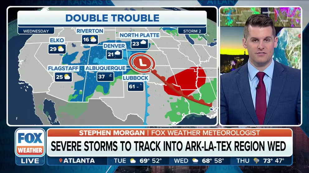
Storm duo will mean snow, rain and thunder for most of the country
the one-two punch of storms continue moving across the U.S. this week. The snow that fell across the Cascades and four corners states pushes into the Plains and the Midwest. Southern states could see severe storms. FOX Weather tracks the storms to let you know when to expect the worst of it.
The FOX Forecast Center is tracking not one but two storms sliding back-to-back across the U.S. this week. Millions of Americans at risk of severe weather, heavy snow and flooding.
Let’s break down each storm and the impacts associated with each system.
Storm No. 1: Fewer impacts

(FOX Weather)
The first storm system moved onshore in Southern California on Sunday and brought some rain to the West. FOX Weather's Max Gorden arrived in snowy Flagstaff just in time for the Monday snow. Officials are asking residents to stay off the roads.
Lower elevations saw rain.
In general, less than a half-inch of rain will fall across parts of Arizona and New Mexico, and snow levels will remain above 4,000 feet with only light accumulations expected.

(FOX Weather)
In Arizona, less than 6 inches of snow is expected, with any chance of seeing a foot of snow confined to the highest elevations of the southern Rockies in New Mexico and southern Colorado.
The storm will then push into the Plains on Tuesday and will bring mostly rain to start before snow eventually begins to fall ahead of the storm departing Wednesday afternoon.
Up to an inch of rain is possible from Texas to Michigan, including the drought-stricken areas of Oklahoma and Kansas.
There is a risk of severe weather in that area on Tuesday, but the threat appears to be low.
Wind will also be an issue across parts of New Mexico, Texas, Oklahoma and Kansas, with wind gusts between 40 and 60 mph not out of the question.
DANGER OF AVALANCHES AND HOW TO STAY SAFE ON THE SLOPES

(FOX Weather)
As the storm system reaches the Upper Midwest, enough cold air will be in place by Tuesday evening and Wednesday morning for snow to break out across portions of Minnesota and the eastern Dakotas.
There is a higher chance of snowfall totals of 3 to 6 inches, and high winds on the backside of the storm could lead to some blowing and drifting snow across the Dakotas. That could lead to low visibility on the roads but should remain below blizzard criteria.
Storm No. 2: Heavy snow, severe weather possible later this week

(FOX Weather)
The second storm system buried higher elevations of the Pacific Northwest on Monday.
The FOX Forecast Center expects heavy snow to taper off across the Cascade Mountains of Washington and Oregon, as well as the Coastal Range in Oregon.
Winter Storm Watches and warnings extend until midday Tuesday. The highest elevations could see up to 2 feet of snow.
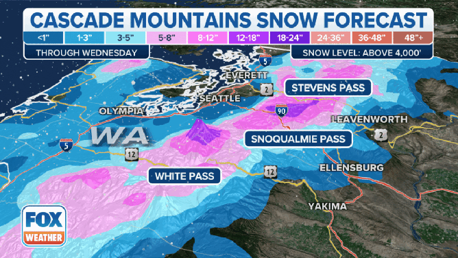
Possible snow totals in the higher elevations of Washington and Oregon.
(FOX Weather)
Snow levels will begin to fall into lower elevations as the day continues, with snow making its way down to the valley floors by Monday evening, according to the FOX Forecast Center.
As the air cools down, valleys and the I-5 corridor could have a tough drive overnight and into the morning especially south of the Puget Sound region, where a few inches of snow is possible overnight.
Snow showers are also possible in cities like Portland and Eugene in Oregon.
Idaho and Montana are also expected to see snow from this storm system, and that could lead to widespread impacts in both states more likely on Tuesday.
Over 2 feet of snow is predicted in the mountains while more populated areas, such as Great Falls, Missoula, Helena and Billings in Montana and Idaho Falls in Idaho, will see a few inches of snow.
DRIVING ON THE ICE AND DRIVING IN THE SNOW: WINTER DRIVING TIPS FOR DRIVING IN INCLEMENT WEATHER

(FOX Weather)
On Tuesday morning, light snow is expected to break out in the mountains of Wyoming, Utah, Arizona and Colorado.
Few impacts are expected initially, but that will all change by Tuesday evening as the strengthening storm system spins its way into the Four Corners region.
Bands of heavy snow with high winds will develop and move east, first impacting Arizona and southwestern Colorado Tuesday night before slamming New Mexico and Colorado Wednesday.
Up to a foot of snow is possible in the higher elevations.
The FOX Forecast Center said there is growing confidence that heavy snow could fall from Kansas to Wisconsin between Wednesday and Friday. Travel impacts are expected, and schools could close as more than 5 inches of snow is forecast to pile up in those regions.
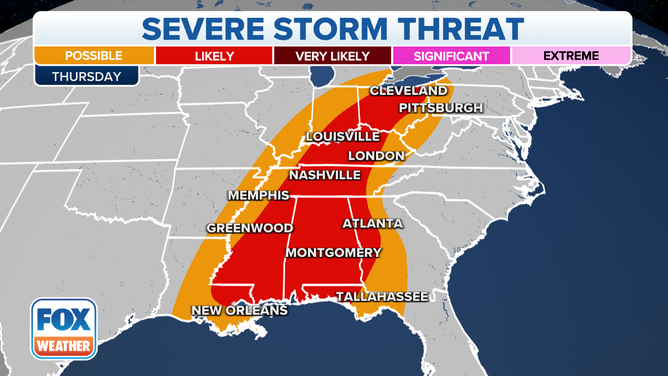
Severe weather eyes South on warm side of storm system
![The severe weather threat on Wednesday, Feb. 15, 2023.]() Image 1 of 2
Image 1 of 2The severe weather threat on Wednesday, Feb. 15, 2023. (FOX Weather)
![The severe weather threat on Thursday, Feb. 16, 2023.]() Image 2 of 2
Image 2 of 2The severe weather threat on Thursday, Feb. 16, 2023. (FOX Weather)
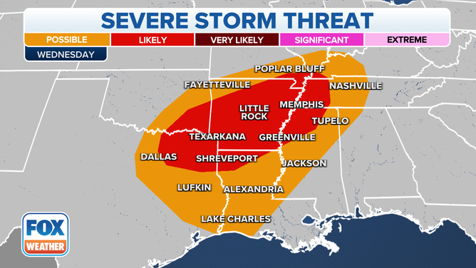
Severe thunderstorms and heavy rain, which could lead to flooding, are expected Wednesday and Thursday on the warm side of the storm system.
THE SPC 5-POINT SEVERE THUNDERSTORM RISK CATEGORY SCALE EXPLAINED
On Wednesday, the primary focus for severe weather will be found across parts of Texas, Louisiana and Arkansas.
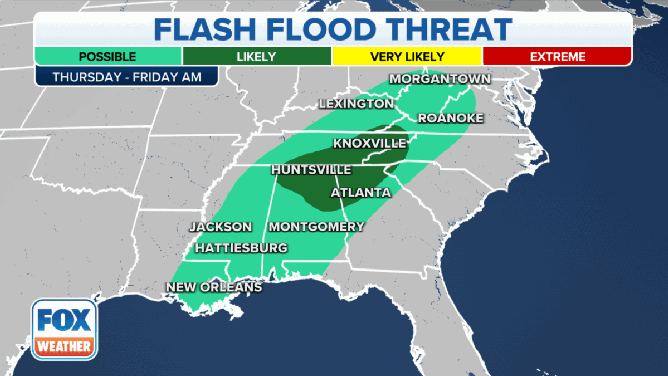
The flash flood threat on Wednesday and Thursday.
(FOX Weather)
The severe weather threat will shift to the east on Thursday, putting millions of people from Mississippi to Ohio at risk.
HERE'S WHERE TORNADOES ARE MOST LIKELY TO OCCUR IN FEBRUARY
Tornadoes, large hail and strong, damaging winds are possible with any of the severe thunderstorms that develop Wednesday and Thursday.