Powerful storm could bring severe weather, blizzard conditions to Plains starting Friday
Severe thunderstorms will rumble across the Central Plains and Midwest while another snowstorm targets the Northern Plains
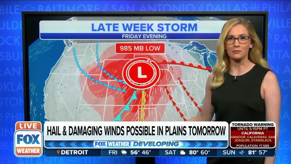
Damaging winds, hail possible in Plains Friday
Damaging winds and hail are possible for the Plains Friday. Wind gusts may go above 50 miles per hour in areas.
A powerful storm system is expected to impact the Plains on Friday and into the weekend which will bring severe weather and another snowstorm with possible blizzard conditions that could target the same areas hit hard last week by a similar storm.
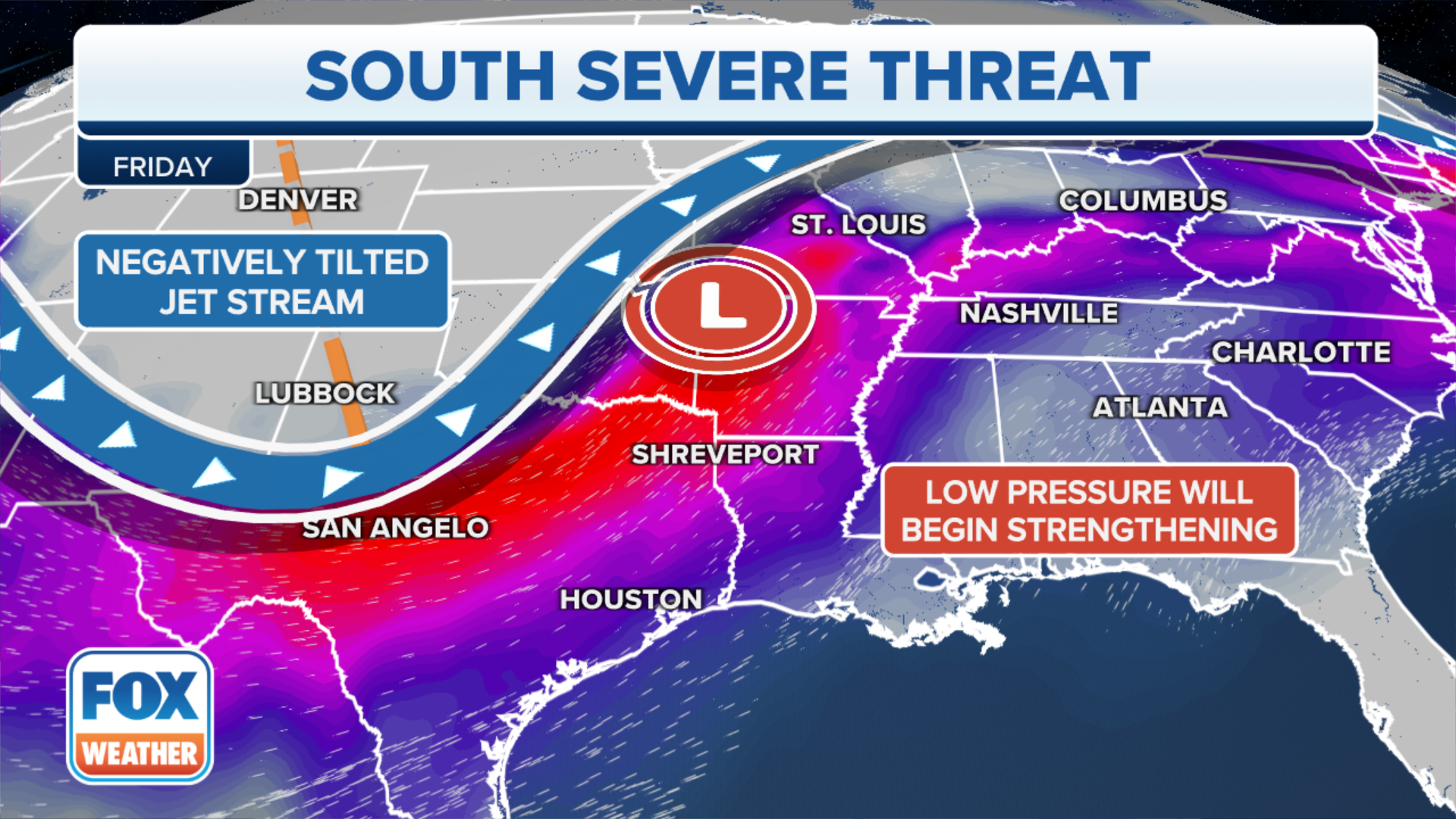
The jet stream will take a sharp, southward plunge and will charge eastward out of the western U.S. and into the Plains, where an area of low pressure will develop.
This low-pressure system will strengthen as it pulls in warm, humid air from the Gulf of Mexico on its southern side and colder air from the Canadian Prairies on its northern side.
HOW TO WATCH FOX WEATHER ON TV
When this type of weather pattern occurs in the spring, it typically results in a sprawling spring storm with both severe thunderstorms and heavy snow – just like we saw last week when more than five-dozen tornadoes hit the Plains, Midwest and South and an April blizzard buried parts of Montana and North Dakota under 3 to 4 feet of snow.
‘ALL WE CAN DO IS PRAY’: PRIZED HORSES BURIED IN SNOW DURING NORTH DAKOTA'S HISTORIC BLIZZARD
Here's what to expect from both the severe weather and snowstorm threats in the Plains.
Severe weather threat
Friday
One or two squall lines could develop across parts of the Central Plains Friday afternoon into Friday night, posing a risk for hail and damaging wind gusts.
Additional thunderstorm activity spreading north of the lower and mid-Missouri Valley into portions of the upper Midwest might pose a risk for large hail as well.
WHAT IS A SQUALL LINE AND WHY IS THIS TYPE OF SEVERE WEATHER SO DANGEROUS?

(FOX Weather)
Saturday
Severe thunderstorms are possible late Saturday afternoon into the evening from parts of central and eastern Oklahoma through eastern Kansas, northwestern Missouri, Iowa and across Minnesota.
Damaging wind gusts and hail appear to be the main threats once again, but a tornado or two cannot be ruled out.
HERE'S WHERE TORNADOES ARE MOST LIKELY TO OCCUR IN EACH MONTH

(FOX Weather)
The risk for severe weather will turn more isolated Sunday and Monday as this system slowly moves eastward. However, the threat of heavy rain will raise flooding concerns from North Texas and eastern Oklahoma to the Ozarks and mid-Mississippi Valley.
Snowstorm threat
Before arriving in the Plains, the storm system will bring beneficial rain and snow to parts of the West and Rockies through Friday.
POTENT STORM SYSTEM TO BRING MUCH-NEEDED RAIN, SNOW TO WEST
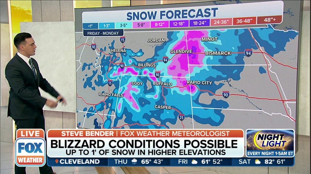
Snow will then spread across portions of Wyoming, Montana and the western Dakotas Friday night into Saturday. Farther east, rain could change to snow in central and eastern North Dakota and northern South Dakota by Saturday night or Sunday.
The National Weather Service has already issued Winter Storm Watches from southern and eastern Montana into north-central and northeastern Wyoming, western and north-central North Dakota and western South Dakota.

(FOX Weather)
The higher terrain of Wyoming, eastern Montana and western and northern North Dakota will likely pick up the most snowfall with this storm. At least 6 inches of heavy, wet snow could pile up in these areas, with the potential for a foot or more in the highest elevations.
Some areas could even see nearly two feet of fresh snow.
Powerful winter storm targeting northern Plains with blizzard conditions possible
For the second week in a row, a powerful winter storm will blast the Northern Rockies and North Dakota with heavy snow and strong winds.
High winds overlapping with the snow might also produce blowing and drifting snow and blizzard conditions resulting in low visibility and dangerous driving conditions.
WHEN CAN YOU EXPECT THE LAST SNOW OF THE SEASON?

(FOX Weather)
While this won't be as bad as last week's crippling blizzard in terms of snow totals in the Northern Plains, it will only add to the misery for those who just dug themselves out.
HERE'S WHY THAT RECORD 3 FEET OF SNOW IN NORTH DAKOTA… DOESN'T COUNT
Be sure to download the FOX Weather app for the latest forecast and weather alerts for your exact location, plus the 24/7 livestream of America's Weather Team – now featuring a new, all-star lineup with live programming weekdays from 6 a.m. to 10 p.m. Eastern time.