Long-duration Southern soaker will continue to pose flash flood threat into this weekend
Several rounds of rain will fuel the threat of flash flooding across the South through at least Saturday. Some areas could pick up 3 to 5 inches of rain.
Freezing rain could lead to some icy roads from Oklahoma to Tennessee
Freezing rain could lead to some icy roads from Oklahoma to Tennessee Thursday morning.
The long-duration rain event that began Sunday across the South will continue through at least Saturday as multiple rounds of additional rain are expected to drench the region.
Warm, moist air being pumped into the southern states by a high-pressure system over the Gulf of Mexico is clashing with cooler, drier air dropping south behind a cold front and reinforced by the jet stream in the nation's midsection. The battleground is in the form of a stationary front draped across the South.

(FOX Weather)
Areas of low pressure and pieces of storm energy will continue to ride along the front and spark round after round of rain and thunderstorms into the start of the weekend.
"Not only are the roadways pretty slippery, but drivers taking it a bit slower, and this is exactly what you should be doing as you head on into work or into school," FOX Weather meteorologist Jason Frazer said.
7 FACTS YOU SHOULD KNOW ABOUT FLASH FLOODS

(FOX Weather)
Thursday-Friday
According to the FOX Forecast Center, the next organized storm system will take shape on Thursday over the central U.S. and track eastward into this weekend.
Steadier rain will likely begin Thursday morning across Oklahoma, Missouri and Arkansas before spreading east toward Kentucky and Tennessee on Thursday afternoon, where the rain will continue at times through Friday.
"This soggy pattern is going to continue to dump several inches of rain, and because of that, we would highly recommend that you take it slow (on the roads)," Frazer said.

(FOX Weather)
Saturday
As a new upper-level disturbance swings in from the west, a final round of light rain is expected to develop Saturday from parts of Texas and Oklahoma to Kentucky and Tennessee, eventually extending south into portions of Arkansas, Louisiana, Mississippi, Alabama and Georgia.
‘IT’S A GULLY-WASHER' AND OTHER WAYS SOME PEOPLE SAY, ‘IT’S RAINING'

(FOX Weather)
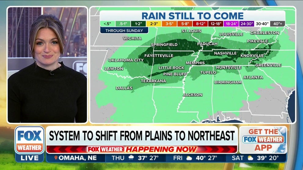
How much rain will fall?
After multiple days of rain this week, a widespread area of the South from central Oklahoma eastward to Tennessee and southern Kentucky will likely pick up 1 to 3 inches of rainfall.
As much as 3 to 5 inches of rain is possible across parts of eastern Oklahoma, Arkansas and southern Missouri.
‘GREENLAND BLOCK’ TO FUNNEL IN ARCTIC AIR, INCREASED SNOW CHANCES ACROSS EAST
While the rain will be largely beneficial for this region because of ongoing drought conditions, it could be too much of a good thing and result in flash flooding if the rain falls too quickly or repeatedly drenches the same areas.
By early next week, some cities in the South may have seen rain for a majority of the past 12 days.

(FOX Weather)