'Greenland block' to funnel in arctic air, increased snow chances across East
The long-range computer forecast models suggest that a late-week storm system will sweep across the nation leading to a pattern change in the East. This comes as a cutoff upper-level high-pressure system begins to develop over Greenland.
Pattern change could lead to snow in parts of eastern U.S. next week
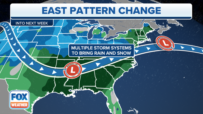
According to the FOX Forecast Center, the long-range computer forecast models suggest that a late-week storm system will sweep across the nation leading to a pattern change in the East.
A major shift in the weather pattern could bring multiple storm systems with rain and snow threats to the eastern U.S. over the next couple of weeks as many Americans wish for a white Christmas.
(FOX Weather)
According to the FOX Forecast Center, the long-range computer forecast models suggest that a late-week storm system will sweep across the nation leading to a pattern change in the East. This comes as a cutoff upper-level high-pressure system begins to develop over Greenland.
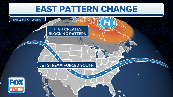
What is a ‘Greenland block’?
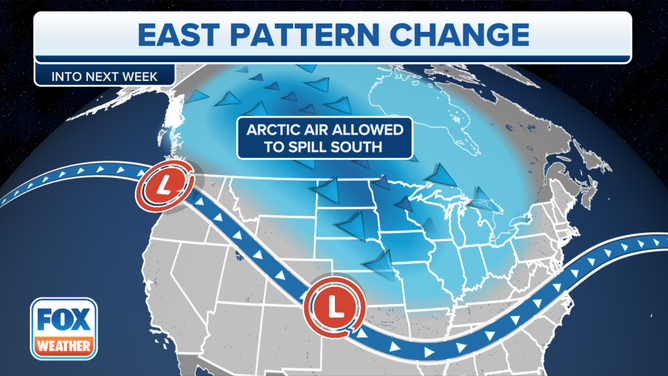
When high pressure parks itself over Greenland, the jet stream is forced to plunge southward across the eastern half of the U.S., allowing arctic air to spill south out of Canada.
In meteorology, this setup is called a "Greenland block" because the high-pressure system over the ice-covered landmass acts as a "block" for the jet stream, keeping it configured with that sharp southward dip across the Midwest and Northeast. This causes the arctic air mass to remain entrenched in those regions.
HERE’S WHEN TO EXPECT YOUR FIRST FREEZE OF THE SEASON
(FOX Weather)
"Typically, this would allow for a colder and stormy pattern for much of the northern tier of the U.S., as multiple storm systems would move through thanks to the Greenland block acting to keep the jet stream farther south," FOX Weather meteorologist Jordan Overton said.
While it is confident that an active pattern will take shape, it is still uncertain how much cold air takes hold.
"That will be key in determining if there will be increasing chances for snow across the Northeast and mid-Atlantic in the coming weeks," Overton added.
HOW COLD CAN TEMPERATURES GET DURING THE COLDEST TIME OF YEAR?
(FOX Weather)
Another reason why it could be cold and stormy
Meteorologists also examine an index called the North Atlantic Oscillation (NAO) to determine the likelihood of a cold, stormy weather pattern developing in the eastern U.S.
It's based on the difference in sea-level pressure between an area of high pressure south of the Azores in the eastern Atlantic Ocean and an area of low pressure between Iceland and southern Greenland in the northern Atlantic Ocean.
The NAO has both a positive and negative phase, where the negative phase correlates with a Greenland block – strong high pressure over Greenland creates that dip in the jet stream over the eastern half of the U.S.
DECEMBER WINTER WEATHER OUTLOOK: COLD AIR TO WIN OUT OVER NORTHERN U.S.

(FOX Weather)
According to projections from NOAA's Climate Prediction Center, the NAO is expected to be in the negative phase for at least the next couple of weeks.
This provides additional evidence supporting a significant dose of cold weather and an increased potential for snow once this blocking pattern is in place over Greenland.