Rare mid-December severe weather outlook issued for South nearly a week in advance
Tornadoes, damaging winds and large hail are all threats late Monday and into Tuesday across the southern Plains and lower Missssippi Valley. Nighttime tornadoes will be a concern, only adding to the danger of this potential severe weather outbreak.
Potential severe weather outbreak could spawn tornadoes, damaging winds in South next week
The FOX Forecast Center is monitoring an increasing potential for a tornado outbreak next Monday and Tuesday across parts of the South.
The FOX Forecast Center is already warning of a possible severe weather outbreak early next week in parts of the South, where tornadoes, damaging winds and large hail will all be possible beginning late Monday.
A large upper-level low-pressure system is forecast to bury many of the Western mountains in feet of snow this weekend, then punch eastward into the Plains on Monday where it will receive an injection of moisture streaming north from the Gulf of Mexico.
At the surface, a powerful cold front associated with that area of low pressure will be sweeping east across the southern Plains, providing the trigger for thunderstorm development as it pushes through the warm, humid air mass engulfing the region.

(FOX Weather)
NOAA's Storm Prediction Center began flagging next week's severe weather threat on Tuesday when it issued a Day 7 outlook for the following Monday highlighting portions of the southern Plains and lower Mississippi Valley for a 15% chance of severe thunderstorms within 25 miles of any point.
On Wednesday, that initial severe weather outlook became the Day 6 outlook, but yet another Day 7 outlook was issued for the following Tuesday slightly to the east of Monday's threat area, also for a 15% chance of severe thunderstorms within 25 miles of any point.
According to the FOX Forecast Center, those two severe weather outlooks issued nearly a week in advance were the only Day 7 outlooks ever issued during the month of December since recordkeeping of the SPC's extended Day 4-8 outlooks began in March 2005.
THE SPC 5-POINT SEVERE THUNDERSTORM RISK CATEGORY SCALE EXPLAINED
Severe thunderstorm timing
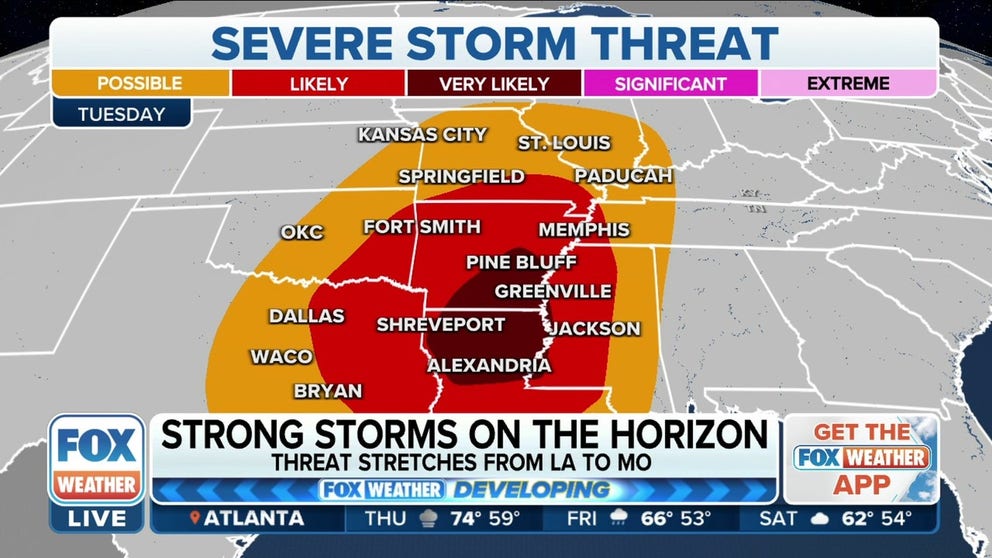
Monday-Monday night
The threat of severe weather Monday will be centered from North Texas into central and eastern Oklahoma and western Arkansas. This includes the Dallas-Fort Worth Metroplex, Norman and Tulsa in Oklahoma and Fort Smith in Arkansas.
Most of the severe thunderstorms will likely occur after dark from Monday evening through the overnight hours when tornadoes, damaging winds and large hail will all be possible.
(FOX Weather)
Nighttime tornadoes are more than twice as likely to result in deaths than those that happen during the day because many people are asleep and caught unaware when a dangerous twister might be headed in their direction.
NIGHTTIME TORNADOES FAR MORE LIKELY TO TURN DEADLY THAN DAYTIME ONES
Make sure you have multiple ways of receiving potentially life-saving weather alerts issued by the National Weather Service, including one that will wake you up during the night.
Tuesday-Tuesday night
As the cold front continues to slide east, the threat of severe storms will follow suit on Tuesday.
The highest threat of severe weather is expected to be focused from East Texas and southeastern Oklahoma into Arkansas, central and northern Louisiana, western Mississippi and far West Tennessee. That includes Little Rock in Arkansas, Shreveport in Louisiana, Jackson in Mississippi and Memphis in Tennessee.
Once again, tornadoes, damaging winds and large hail will all be possible with Tuesday's thunderstorms.
HOW YOU SHOULD PREPARE FOR A TORNADO

(FOX Weather)
The risk of severe weather on Wednesday remains uncertain as this system moves into the Southeast, but current indications suggest a much more limited potential for strong storms due to lower amounts of available Gulf moisture.
Are long-range severe weather outlooks becoming more common?
SPC forecaster Liz Leitman told FOX Weather that it's relatively uncommon to have high enough confidence to highlight a significant severe weather threat so far in advance at this time of year – it is meteorological winter, after all – but it's not completely unprecedented thanks to recent advances in weather forecasting.
She said new tools available to meteorologists can increase their confidence, allowing them to issue severe weather outlooks with more lead time than in years past. The SPC is also trying to be more aggressive with its forecasts in order to raise awareness as far in advance as possible.
SECRETS OF THE SPC: HOW DAILY CONVECTIVE OUTLOOK GRAPHICS ARE MADE
"We always got feedback that other (meteorologists) didn’t like when our (severe weather risk) areas moved around in the short term (Day 1-3), so given uncertainty in the extended (outlook), we didn’t put a lot of areas in, knowing they’d likely move around," Leitman explained. "Over the past few years, it’s been apparent that the previous feedback didn’t apply to the extended time range, so we’re changing our approach."
She went on to mention that a combination of new forecasting tools, a better understanding of the public's needs and changing the approach to the extended Day 4-8 outlooks have all contributed to increased forecaster confidence, allowing the SPC to issue more frequent long-range outlooks without the fear of people losing trust in their ability to accurately predict severe thunderstorms.