Quick-moving storm brings blast of snow to the Northeast
The storm won't bring too much as far as snow accumulations but travel both in the air and on the ground in across parts of the Northeast may be impacted through Tuesday morning.

Early week snow for Pennsylvania, New York New Jersey
A quick moving storm brings rain changing to snow from the Great Lakes to the Northeast. Most snowfall amounts will be light, but higher elevations could see up to 7 inches before the morning commute.
The quick-moving storm system that brought snow to the Midwest on Monday continues to spin off through the Northeast. The storm isn't expected to bring significant impacts, but could trigger travel delays for the Tuesday morning commute.
Initially, most of us will get a rain snow mix and eventually change over to all snow. Only the highest elevations will see more than a couple of inches. The NWS issued a Winter Storm Warning for parts of Pennsylvania that could see 3 to 5 inches of snow with up to 7 inches locally.
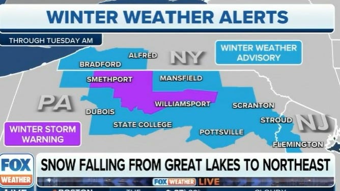
Winter weather alerts.
(FOX Weather)
DRIVING ON THE ICE AND DRIVING IN THE SNOW: WEATHER DRIVING TIPS FOR DRIVING IN INCLEMENT WEATHER
Areas in the Winter Weather Advisory across western New York, Pennsylvania and eastern New Jersey could see 2 to 4 inches of snow. Since it starts out as rain, it will be very heavy wet snow.
Most of the snow will fall before sunrise so be ready to clear off the windshields before heading to work and school. Watch out for icy patches on bridges and overpasses.
HOW COLD DOES IT HAVE TO BE TO SNOW?

(FOX Weather)
The New York Metro area and I-95 corridor through New Jersey will see some snow but it will generally be nuisance snow, under an inch. With high temperatures heading into the low 40s, any winter snow won't stick around very long.
The FOX Forecast Center keeps the Northeast fair but breezy until the next system moves in for the end of the week.