Rare June severe weather outbreak across South produces hurricane-force wind gusts, tornadoes
Possibly record-breaking size hail was reported in Mississippi, while a violent tornado was caught on video via a drone in southwestern Georgia.
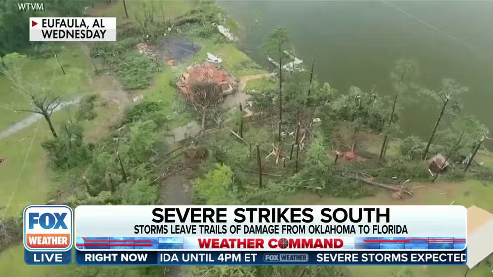
Tornado damage cleanup underway in Alabama with more severe weather forecast
FOX Weather's Nicole Valdes is in Eufaula, Alabama where the community is cleaning up after severe weather and a possible tornado. The threat of severe weather continues on Thursday.
A rare June southern severe weather outbreak impacted nearly nine states on Wednesday and produced destructive winds, damaging hail and even a few tornadoes.
During the height of the severe weather, more than 16 million residents from Texas to Florida were under either under a Tornado Watch or a Severe Thunderstorm Watch.
Possibly record-breaking size hail was reported in Mississippi, while a violent tornado was caught on video in southwestern Georgia.
Dozens of severe weather reports from 9 states
The severe weather outbreak started in East Texas and Louisiana, where a possible tornado damaged buildings and cars in Atlanta, Texas.
The area was under a Tornado Warning as the severe storm rolled through. Photos showed several vehicles that had substantial damage, with windows that were blown out.

Possible tornado damage near Atlanta, Texas. June 14, 2023.
(@_freezeplays / Twitter / FOX Weather)
Further eastward, the director of public utilities in Eutaw, Alabama, said three people were trapped, and one person was hospitalized due to a fallen tree.
The injuries were considered non-life threatening, and first responders were at the scene for several hours.
In the eastern portion of the state, supercells produced confirmed tornadoes near the Alabama-Georgia border. Chase Osborne posted a video to Facebook that shows the suspected tornado crossing U.S. 431 in Abbeville on Wednesday afternoon.
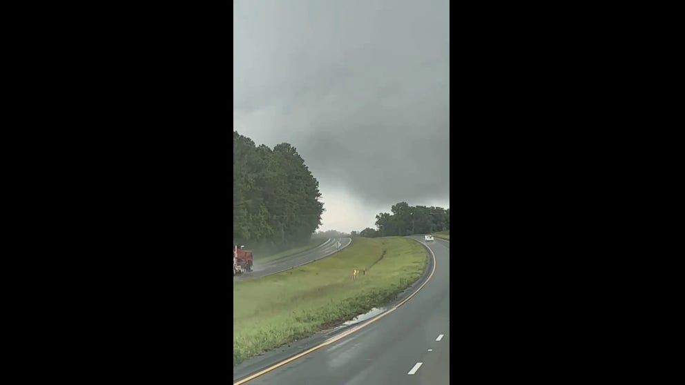
Watch: Possible tornado crosses Alabama highway
Watch as a possible tornado crosses U.S. 431 in Abbeville, Alabama, on Wednesday, June 14, 2023.
Bradley Bedwell was in Abbeville shortly after the likely tornado moved through the town, and a video he recorded shows buildings severely damaged by the storm. As the camera pans to the right, trees are seen snapped in half after the storm crosses the road.

Watch: Video shows damage caused by likely tornado in Alabama
Video recorded in Abbeville, Alabama, after a likely tornado tore through the community on Wednesday, June 14, 2023.
The police department in Eufaula, Alabama, reported that a tornado had done damage in the town, and assessments were underway.
According to PowerOutage.us, there were nearly 1,000 outages in Barbour County, in southeast Alabama, part of about 200,000 who lost power across the South during the peak of the storms.
Alabama Power reported about 17,700 customers throughout Montgomery without power on Thursday. Montgomery Mayor Steven Reed said city and utility crews were working to clear debris and restore power.
![Tornado damage in Alabama]() Image 1 of 8
Image 1 of 8Severe storm damage on 6/14/2023 in Eufaula, Alabama (Eufaula Alabama Police Department)
![Tornado damage in Alabama]() Image 2 of 8
Image 2 of 8Severe storm damage on 6/14/2023 in Eufaula, Alabama (Eufaula Alabama Police Department)
![Tornado damage in Alabama]() Image 3 of 8
Image 3 of 8Severe storm damage on 6/14/2023 in Eufaula, Alabama (Eufaula Alabama Police Department)
![Tornado damage in Alabama]() Image 4 of 8
Image 4 of 8Severe storm damage on 6/14/2023 in Eufaula, Alabama (Eufaula Alabama Police Department)
![Tornado damage]() Image 5 of 8
Image 5 of 8Tornado damage in Eufaula, Alabama (FOX 54 WXTX)
![Tornado damage]() Image 6 of 8
Image 6 of 8Tornado damage in Eufaula, Alabama (FOX 54 WXTX)
![Tornado damage]() Image 7 of 8
Image 7 of 8Tornado damage in Eufaula, Alabama (FOX 54 WXTX)
![Tornado damage]() Image 8 of 8
Image 8 of 8Tornado damage in Eufaula, Alabama (FOX 54 WXTX)


Police reported there were no injuries, but several structures in the town were damaged.
Steven Watkins, chief of the Eufaula Police Department, said the town was fortunate only to receive limited damage.
"We had several houses that have the roof damage, tree falling on them. I have two apartment complexes that lost their roofs and had trees on them and a business that lost an entire wall. But thankfully, it's only structural damage."
The apparent tornado was also captured moving through Alabama on video by Shalene Wofford.
"In Eufaula, we have actually had a tornado touch down in the city limits four out of the last five years. So, we're familiar with the spring storms. But yes, but usually, our summer storms are more wind events. So, this was highly unusual this time of year for us- mainly ours are March or April," said Watkins.
Drone video from Newton, Georgia, showed a powerful tornado moving through rural areas between Albany and Tallahassee, Florida, during the early evening.
The region was under a Tornado Watch at the time the intense thunderstorms moved through and triggered numerous Tornado Warnings.

Watch: Tornado spotted in southwestern Georgia
The tornado filmed in Newton, Georgia. June 14, 2023. (Courtesy: SevereStudios.com/Jordan Hall)
The storms also dropped massive hailstones, and if witness reports are confirmed, the ice could be near-record breaking in Mississippi.
A hailstone measured around 5" in Brooksville, Mississippi, which is the same size as the current record holder from Oxford, Mississippi, on April 10, 1962.

Massive hail fell around Brooksville, Mississippi on Wednesday afternoon.
(Dianne Pruitt / FOX Weather)
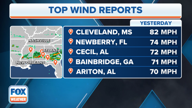
Mississippi also was home to the storm's peak-measured wind gust, reaching 82 mph in the town of Cleveland. Four other towns in the South recorded gusts over 70 mph, including Newberry, Florida, which reached a gust of 74 mph.
(FOX Weather)
Down trees knock out power to thousands in Florida's Big Bend, South Georgia
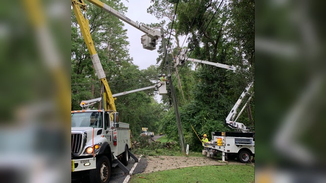
Utility workers repair powerlines in Tallahassee, FL on Thursday, June 15, 2023 after a severe storm caused widespread damage. (Image: City of Tallahassee)
(FOX Weather)
Crews in Florida's Panhandle and Big Bend areas are cleaning up debris from the severe thunderstorms which knocked out power to about 12,500 customers at one point, according to Tallahassee city officials.
Most of the damages across Florida's capital are from large trees and tree branches toppling during the storm.
TRACK THE STORMS USING THE FOX WEATHER APP'S 3D RADAR
Power and other utility crews were out Friday working to repair power lines as city crews moved massive debris piles and tree branches.
In Tallahassee, a peak wind gust was recorded at 56 mph during the storm.
Severe storm threat persists through the weekend
Both the Southeast and the Plains will face the threat of severe thunderstorms on Thursday and Thursday night, though the storms are not expected to be as intense as Wednesday.
Still, nearly 20 million people from western Oklahoma and Kansas through the South and into the Florida Panhandle are once again threatened by damaging wind gusts, hailstones larger than 2–3 inches, and tornadoes.
(FOX Weather)
Scattered severe thunderstorms are possible Friday and Friday night in a corridor stretching from the central Plains through the lower Mississippi Valley and parts of the Southeast, and additional rounds of severe weather are likely this weekend as a jet stream disturbance slides east across the Plains and mid-South.