Deadly storms sweep across Plains, Southeast Thursday with multiple tornado reports
A destructive tornado moved through Perryton, Texas, on Thursday. Dozens of structures appeared to damaged by the tornado.

Drone video shows tornado damage in Texas town
Storm chaser Brian Emfinger is one of the first on the scene after a tornado hit Perryton, Texas. He said mobile home after home was flattened and one building is on fire.
A second night of severe storms across the South and the southern Plains led to deadly tornados and destructive winds for more than a dozen states and left over 600,000 people without power.
One of the hardest hit towns was Perryton, Texas, where a tornado tore through neighborhoods, leaving at least 3 dead and dozens injured.
Damage appeared to be focused on the downtown region and in a neighborhood around an industrial site, with pieces of metal wrapped around utility poles and trees stripped of leaves.
Storm trackers said the tornado was on the ground for several minutes and also damaged a mobile home park.
First responders were spotted on scene just minutes after the tornado moved through, and drone video showed at least one fire burning uncontrollably through a mobile home.

First video of tornado damage in Perryton, TX
Storm chaser Brian Emfinger was one of the first to arrive on the scene at Perryton, Texas moments after the confirmed tornado moved through.
"There are homes that are damaged everywhere…It is so early, and access is so limited. There are a lot of people driving around," said Brian Emfinger, a storm tracker, who was close to the twister. "I don't know how many were destroyed, but I would guess at least ten. And there were other significant structures along its path all the way through town that are damaged. It's a pretty serious situation here - very sad right now."
After the storm, video showed dozens of structures damaged by the twister, and witnesses reported storm victims being pulled from the rubble and storms chasers were requesting ambulances respond to the town to help the injured. Emfinger said the smell of gas was prevalent, and people were using their hands to dig through the debris.

Texas residents emerge from Tornado shelters to assess damage
Storm chaser Brian Emfinger brings us back to Perryton, Texas now that the tornado has cleared. Slowly residents are coming out from their shelters to assess the damage and offer help to those who need it.
"It looks like a bomb had gone off," Sabrina Devers, a Perryton resident, told FOX Weather. "The residential areas, the mobile homes, are just gone. There’s severe devastation."
The National Weather Service office in Amarillo will be tasked with surveying the damage and determining a rating of the twister on the Enhanced Fujita Scale.
'It looks like a bomb had gone off': Texas resident describes violent tornado
Rescue efforts are underway in the town of Perryton, Texas, after a destructive tornado moved through on Thursday.
Northwest Ohio impact by tornadic activity
At least one tornado struck east of Toledo, Ohio on Thursday evening.
Initial storm reports indicated many trees and power lines were damaged during the storm, but there were no initial reports of injuries.

Storm sends debris flying in Toledo, Ohio
A severe storm and possible tornado swept away a roof and other debris in a Toledo, Ohio, neighborhood Thursday. (Video: Blake Loy/WEATHER TRAKER /TMX)
"The strong storm system that moved through the area has caused significant equipment damage, particularly in the Point Place section of Toledo where there are well over a dozen broken poles and downed power lines," said a spokesperson for Toledo Edison stated.
PowerOutage.us reported around 25,000 electrical outages with most centered in counties around Lake Erie.

Tornado forms outside of Toledo, Ohio
A tornado was seen forming at the Maumee Bay State Park Golf Course in Oregon, Ohio, located just northwest of Toledo.
Line of severe thunderstorms knocks out power to hundreds of thousands
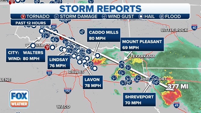
In the Plains, a line of severe thunderstorms swept across hundreds of miles from Oklahoma through Texas and Louisiana and into Mississippi Thursday night, bringing a widespread swath of damaging wind gusts.

(FOX Weather)
A wind gauge in Norman, Oklahoma recorded a gust of 84 mph while Walters, Oklahoma reached 80 mph.
Gusts in northeastern Texas raced over 75 mph, including Lavon (78 mph) and Lindsay (76 mph). A gust of 70 mph hit Shreveport, Louisiana and gusts reached 62 mph in Jackson as the storms reached into Mississippi early Friday morning.
(FOX Weather)
Over 600,000 were without power by 10 a.m. ET, according to PowerOutage.US, with 226,000 without power in Texas and over 182,000 in the dark in Louisiana. Additional power outages were possible in eastern Mississippi and into Alabama as the line continued its trek east Friday morning.
Life-threatening flash flooding in Florida
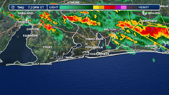
Meanwhile, the Pensacola area got a one-two punch of an apparently deadly tornado and then life-threatening flash flooding. A possible tornado struck Thursday night, downing trees and power lines, leaving one person dead when a tree crashed into their home, according to Escambia County Fire Rescue.
Then, the torrential rains began as a cluster of thunderstorms stalled over the city, dropping over a foot of rain in the area and triggering dangerous flash flooding.
(FOX Weather)
Flash Flood Emergencies covered over 100,000 people, stretching from Pensacola through Warrington and Myrtle Grove as spotter reports to the National Weather Service indicated flooded roads and homes with waters still rising in some areas.
The NWS estimates some areas have received 8-15 inches of rain over just several hours, with more rain likely to fall through the morning. A rain gauge in Gulf Breeze reported 14.08 inches in 6 hours while Pensacola airport reported 9.23 inches of rain in a 5-hour period.
"Extremely busy night for us," said Deputy Fire Chief Paul Williams with Escambia County Fire Rescue. "There's been numerous water rescues, flooding condition calls, rescuing folks from their houses or their cars when they're driving through some intersections that are submerged with water."
More severe storms likely Friday into the weekend
There is no rest of the storm fatigued as the weather pattern once again remains conducive to severe storms Friday into the weekend. The severe weather threat is not as high as it's been the past two days but still warrants plenty of attention.
Supercell thunderstorms are expected to refire across the Southeastern threat zone Friday afternoon and evening as atmospheric instability returns, but with damaging wind gusts and large hail are the primary severe weather threats. Another area of concern is back in the Plains where a Level 2 out of 5 severe weather risk is in place for eastern Colorado and western Kansas.
Additional rounds of severe weather are likely this weekend as a jet stream disturbance slides east across the Plains and mid-South.