Severe thunderstorms target Southeast bringing threat of tornadoes, damaging winds
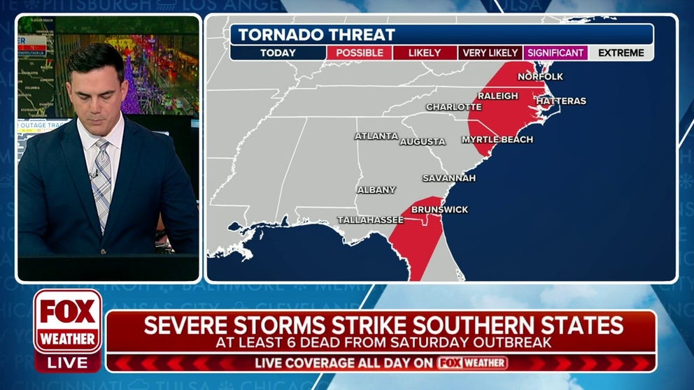
Severe thunderstorms continue on Sunday from parts of Florida to the eastern Carolinas and Virginia, with the potential for a few tornadoes. This storm system already produced a deadly tornado outbreak in the South on Saturday.
Severe storms with tornado threat targets north Florida, Carolinas, Virginia
A line of severe thunderstorms continues to trek east, bringing damaging winds and reports of tornadoes across the southern states. Tornado Watches for parts of Florida, North Carolina and Virginia continue into Sunday night.
TALLAHASSEE, Fla. – A potent storm sweeping across the eastern U.S., producing a deadly tornado outbreak in parts of the South on Saturday, continues to pack a dangerous threat of damaging winds and possible tornadoes on Sunday for the Southeast and mid-Atlantic states.
NOAA's Storm Prediction Center (SPC) issued a Level 2 out of 5 risk for severe thunderstorms over parts of the eastern Carolinas, southeastern Virginia, north Florida and far southern Georgia. Severe weather is also possible outside these areas, as a Level 1 out of 5 risk was issued from Florida to Delaware and Maryland.
VIDEOS SHOW TORNADO THAT BARRELED THROUGH CLARKSVILLE, TENNESSEE
Sunday severe weather outlook.
(FOX Weather)
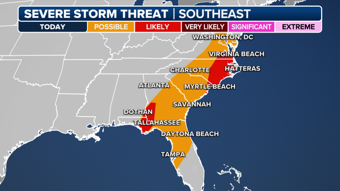
The severe weather threat on Sunday morning was mainly over the Gulf Coast states before shifting toward the Southeast and mid-Atlantic in the afternoon.
Multiple Tornado Warnings were issued throughout the day on Sunday in Florida, Alabama, Georgia, North Carolina and Virginia.
A tornado was spotted near Raleigh, North Carolina, just before 1 p.m. Spotters say they observed it moving southeast of the major city.
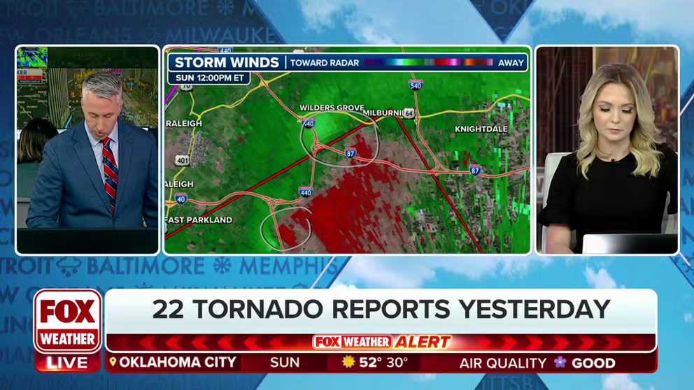
Tornado observed near Raleigh, North Carolina
A Tornado Warning was issued Sunday afternoon that included portions of Raleigh, North Carolina. Spotters say they observed a tornado with this cell just before 1 p.m.
Tornado Watches were issued through parts of the mid-Atlantic and Southeast on Sunday, with parts of coastal Virginia and North Carolina under alert through the late evening hours.

(FOX Weather)
Damage was reported near the Florida-Georgia line in Thomasville after the tornado-warned storm moved into southern Georgia late Sunday morning.
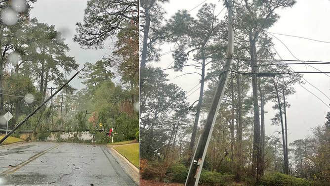
Trees and powerlines down in south Georgia after a severe thunderstorm moved through the area on Sunday, Dec. 10, 2023. (Image: @taylorm37245022/X)
(FOX Weather)
Gusting winds up to 55 were recorded on Jekyll Island, Georgia on Sunday, according to the National Weather Service in Jacksonville.
By Sunday afternoon, the severe weather threat shifted into the Southeast and mid-Atlantic states, bringing risks of heavy rain, damaging wind gusts and a few tornadoes.

(FOX Weather)
The greatest threat for severe weather is the eastern Carolinas and southeastern Virginia, including Norfolk and Virginia Beach in Virginia and Hatteras, Wilmington and Durham in North Carolina.
HERE'S WHERE TORNADOES ARE MOST LIKELY TO OCCUR IN EACH MONTH

(FOX Weather)
Ahead of a cold front moving in, frequent wind gusts between 35 and 45 mph are possible through Sunday night into Monday morning.
More than 3 inches of rain is forecast through Monday, bringing the threat of localized flash flooding and standing water on roads.
Powerful storm produces deadly tornado outbreak in Tennessee, Kentucky
![Extensive damage is seen in the Nashville area after a deadly tornado outbreak on Saturday, Dec. 9, 2023.]() Image 1 of 7
Image 1 of 7Extensive damage is seen in the Nashville area after a deadly tornado outbreak on Saturday, Dec. 9, 2023. (@NashvilleEOC/X)
![Extensive damage is seen in the Nashville area after a deadly tornado outbreak on Saturday, Dec. 9, 2023.]() Image 2 of 7
Image 2 of 7Extensive damage is seen in the Nashville area after a deadly tornado outbreak on Saturday, Dec. 9, 2023. (@NashvilleEOC/X)
![Tornado damage is seen in Clarksville, Tennessee, on Dec. 9, 2023.]() Image 3 of 7
Image 3 of 7(Clarksville Fire Rescue)
![Tornado damage is seen in Clarksville, Tennessee, on Dec. 9, 2023.]() Image 4 of 7
Image 4 of 7Tornado damage is seen in Clarksville, Tennessee, on Dec. 9, 2023. (Clarksville Fire Rescue)
![Tornado damage in Clarksville]() Image 5 of 7
Image 5 of 7Tornado damage in Clarksville, TN (Clarksville Fire Rescue)
![]() Image 6 of 7
Image 6 of 7Tornado damage in Clarksville, TN (Clarksville Fire Rescue)
![Clarksville Fire Rescue]() Image 7 of 7
Image 7 of 7Clarksville, Tennessee tornado damage (Clarksville Fire Rescue)


The threat of tornadoes with this storm system is real and has already brought deadly consequences. On Saturday, six people were killed during a tornado outbreak in parts of Tennessee and Kentucky.
Extensive damage and injuries were reported across northwestern parts of Tennessee after a Tornado Warning on Saturday was later declared a "Particularly Dangerous Situation."
The same supercell produced a tornado that tracked into Kentucky, destroying several homes and injuring dozens of people.
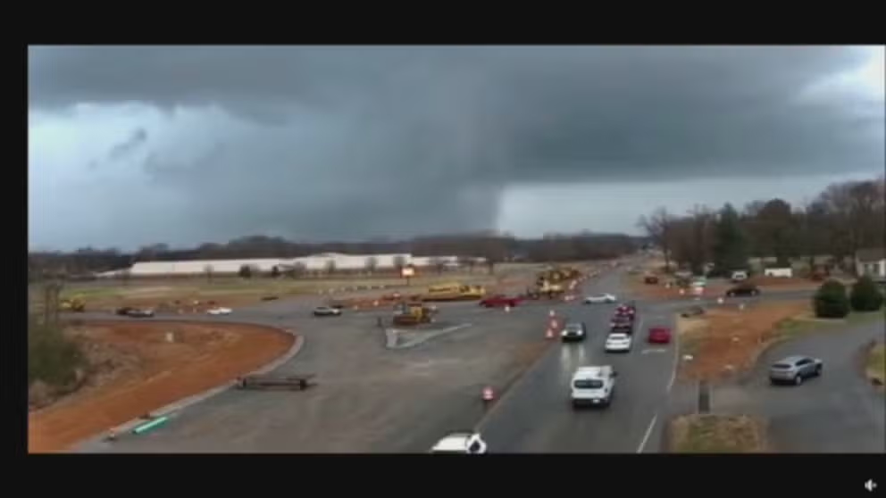
Traffic camera captures supercell moving through north Tennessee
A traffic camera in Clarkesville, Tennessee, captured a severe thunderstorm with a likely embedded tornado moving through the northern part of the state on Saturday.