Severe thunderstorm threat moves into Northeast, mid-Atlantic on Tuesday
The greatest risk for isolated severe storms stretches from northwestern Maine though Upstate New York and into the mid-Atlantic States, including the cities of Philadelphia, Baltimore, Washington, Richmond and Rochester, New York.
Severe storm threat could bring heavy rain, gusty winds from VA to Maine
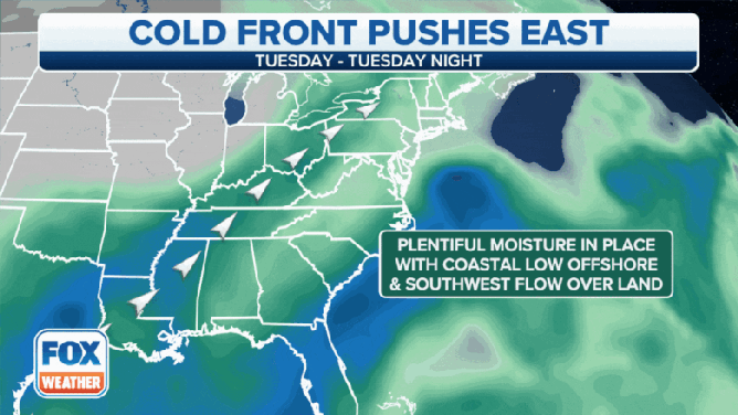
A cold front charging east will be the focal point for showers and thunderstorms along the east coast on Tuesday.
ROCHESTER, N.Y. -- A cold front that brought damaging winds to the Great Lakes area, leaving over 600,000 without power in Michigan, will sweep into the Northeast and Mid-Atlantic states Tuesday, though it's not expected to have quite as much of a punch.
Still, scattered showers and thunderstorms will develop near the frontal boundary, and the atmosphere is still warm and muggy enough that some of those storms could be severe.
HOW TO WATCH FOX WEATHER ON TV
"We have a ton of tropical moisture moving in from the Gulf of Mexico," says FOX Weather Meteorologist Britta Merwin. "All that moisture is being lifted into the Northeast -- that's why it feels a little sticky outside; you're feeling the humidity."
(FOX Weather)
But the cold front is going to run into the warm and humid air Tuesday, "sending air surging up into the atmosphere and supporting these strong thunderstorms," Merwin said. "And as that cold front really interacts with daytime heating and all that moisture, it's only going to add up to more problems."
The greatest risk for isolated severe storms stretches from northwestern Maine through Upstate New York and into the mid-Atlantic States, including the cities of Philadelphia, Baltimore, Washington, Richmond and Rochester, New York.

(FOX Weather)
Storms will sweep through these areas midday Tuesday into Tuesday afternoon.
"Daytime heat is a big player here," Merwin said. "We need all that heat to really support those stronger storms. So I wouldn't anticipate many warnings until we get after lunchtime."
But when they arrive, some could bring impactful weather.
"You have that potential for not only seeing some rain but also damaging winds gusting up to right around 50 mph," added FOX Weather Meteorologist Jason Frazer. "I would not be surprised to see some downed trees and downed power lines as well."

(FOX Weather)
The front will eventually reach the I-95 corridor by around the Tuesday evening commute, though the storms are expected to lose some potency as they reach the Atlantic coastline.
"A lot of those thunderstorms are going to arrive in the I-95 corridor around 7 p.m., so if you're an early commuter, it's going to be easier for the I-95 corridor," Merwin said. "But if you're somebody who leaves the office in (Washington) D.C, New York or Philadelphia later in the evening around 8 o'clock, you could have a tricky time."
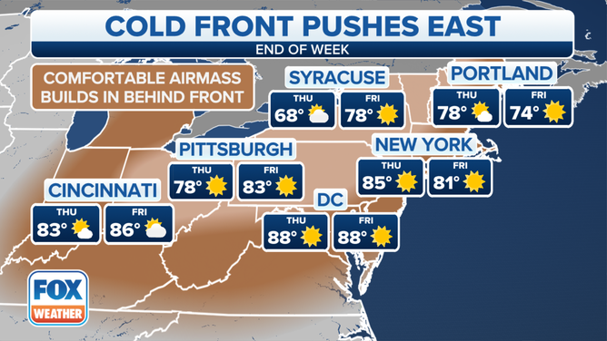
The price for Tuesday's rain will be much more comfortable temperatures and humidity levels in the wake of the front for the end of the week.
(FOX Weather)