Severe weather, flash flooding possible from Great Lakes to South
The severe weather threat will shift to the East Coast by Friday
Severe storms and flash flood threat from Gulf Coast to Great Lakes
Severe storms and flash flood threat from the Gulf Coast to the Great Lakes through Thursday. Some areas of Florida have seen significant rain.
A storm system that brought severe weather and flash flooding to parts of the Southern Plains and South this week will continue to shift off to the north and east on Thursday, impacting parts of the Gulf Coast, the Tennessee and Ohio Valleys and the Great Lakes.
HOW TO WATCH FOX WEATHER ON TV

(FOX Weather)
7 FACTS YOU SHOULD KNOW ABOUT FLASH FLOODS
Flash flooding is also a possibility on Thursday, with the highest threat focused along the Gulf Coast from southeastern Louisiana to the Florida Panhandle. The flooding risk also stretches across areas of the Southeast, the Tennessee and Ohio Valleys and locations near the Great Lakes.

(FOX Weather)
Cities with the highest risk of flooding include Mobile, Alabama and Tallahassee, Florida.
Flash flooding is also likely in Montgomery, Alabama, Atlanta and Greenville, South Carolina.
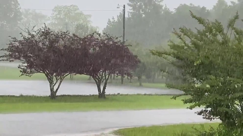
Heavy rain across North Alabama
Heavy rain is seen falling in Moulton, Alabama on Thursday. (Video: @dopplerneal/Twitter)
And while cities from Nashville to Indianapolis, Cleveland and Chicago will also be at risk of flooding on Thursday, the threat is much lower than that in the South.
MEMORIAL DAY TRAVEL FORECAST: WHERE RAIN COULD DAMPEN YOUR SUMMER KICKOFF

(FOX Weather)
Several inches of rain are expected to fall across the eastern half of the United States through at least Saturday.
However, areas that will likely see the highest totals will be found in the Southeast. Some areas of northeastern Georgia and western parts of the Carolinas could see upward of 5 inches of rain.
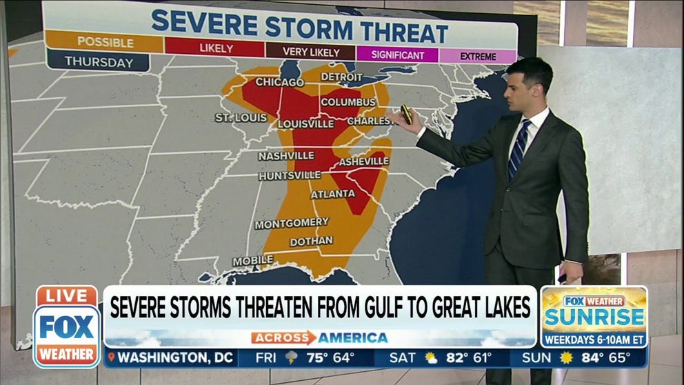
Severe storm threat

(FOX Weather)
Millions of Americans are at risk of seeing severe weather on Thursday.
However, areas where severe thunderstorms are likely include eastern Alabama, the Florida Panhandle and northwestern Georgia, as well as points to the north into the Tennessee and Ohio Valleys and along the Great Lakes.
Several major cities are under the threat, including Chicago and Columbus, Louisville, Kentucky and Nashville.
Huntsville and Montgomery, Alabama are also included in that threat, as well as Atlanta.
HERE'S WHERE TORNADOES ARE MOST LIKELY TO OCCUR IN EACH MONTH
![]() Image 1 of 3
Image 1 of 3The tornado threat on Thursday, May 26. ( )
![]() Image 2 of 3
Image 2 of 3The damaging wind threat on Thursday, May 26. ( )
![]() Image 3 of 3
Image 3 of 3The large hail threat on Thursday, May 26. ( )
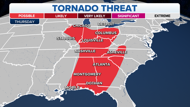
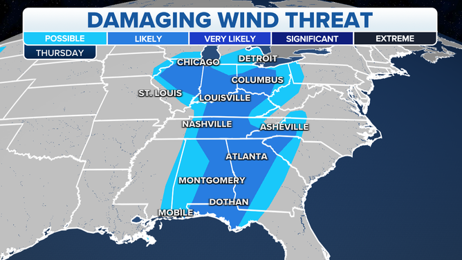
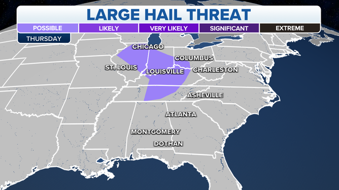
Tornados, large hail and wind are the threats accompanying any severe thunderstorms that develop on Thursday.
Tornadoes are possible from Mobile, Alabama and into the Southeast, including the Atlanta area and parts of the Tennessee and Ohio Valleys.
Large hail could also be an issue in parts of the Great Lakes and Ohio Valley, including the cities of Chicago, Louisville, Kentucky.
The threat of damaging winds extends from Chicago and the Great Lakes region, as well as to the south into the Ohio and Tennessee Valleys and the Southeast and Gulf Coast.

(FOX Weather)
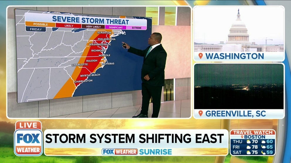
The threat of severe weather will move to the East Coast on Friday, with millions of people at risk of damaging winds, large hail and a possible tornado.
East Coast under threat of severe weather for Friday
A more widespread severe weather episode could evolve over the East Coast Friday as a line of storms pushes through along the front.
While severe weather is possible from Georgia to northern New England, the highest risk will be centered from South Carolina, including Charleston and Myrtle Beach, through the mid-Atlantic and parts of the Northeast.
This means people in Washington, D.C., Philadelphia, and the New York City metro should keep an eye on the sky.
Significant severe weather, including tornadoes, possible in Upper Midwest this weekend
Models are beginning to converge towards a scenario in which significant severe weather could be possible this weekend.
There's also a threat of severe this weekend across the Plains and parts of the Midwest.
The severe thunderstorm threat on Saturday, May 28.
(FOX Weather)
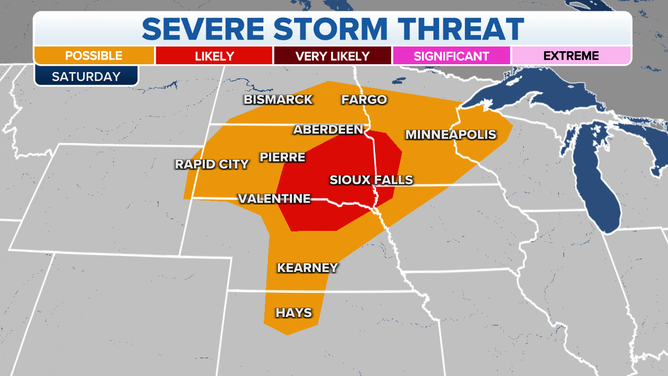
The threat will primarily be focused in the Central and Northern Plains, as well as parts of the upper Midwest.
Severe storms on Saturday are likely in northern Nebraska, southeastern South Dakota and southwestern Minnesota.
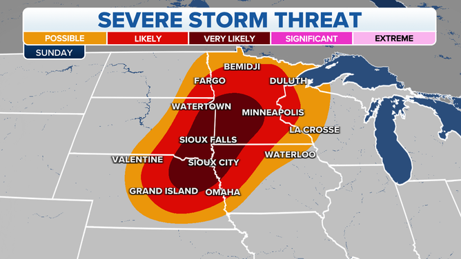
The severe thunderstorm threat on Sunday, May 29.
(FOX Weather)
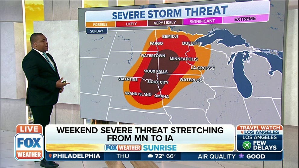
There's a higher risk of severe weather on Sunday across the same region.
Severe weather is possible from east-central Nebraska into eastern South Dakota, southeastern North Dakota, and all of Minnesota as well as parts of northwestern Iowa and northwestern Wisconsin.
CLICK HERE TO GET THE FOX WEATHER UPDATE PODCAST
Storms are very likely from areas near Sioux City, Iowa, Sioux Falls, South Dakota and creeping close to the Minneapolis-St. Paul area.
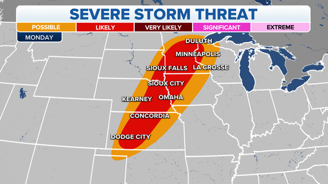
The severe thunderstorm threat on Monday, May 30.
(FOX Weather)
That region could see a third day of severe weather on Memorial Day, with that threat stretching from Dodge City, Kansas into Omaha, Nebraska, Minneapolis and Duluth, Minnesota.
Be sure to download the FOX Weather app for the latest forecast and weather alerts for your exact location, plus the 24/7 livestream of America's Weather Team.