Severe storms, flash flooding snarl travel along I-95 corridor from Washington to Philadelphia
NOAA's Storm Prediction Center issued a Severe Thunderstorm Watch for Tuesday afternoon and evening, covering much of the heavily populated Interstate 95 corridor from New Jersey through Virginia.

Strong storms targeting I-95 corridor in Northeast
Flash flooding is possible as severe storms take aim at the northeast. Damaging winds are also expected from this round of storms.
A sweeping cold front made for an active Tuesday along the Northeast's Interstate 95 corridor, spawning numerous showers and thunderstorms, and disrupting travel for millions.
The front will eventually stall along the Southeast coast, where it becomes more of a tropical threat down the line, the FOX Forecast Center said.
The line of storms up and down the East Coast dampened travel as many are flying out or hitting the road for the holiday weekend. Tuesday's storms caused delays and headaches at most major airport hubs.
Ground stops were in place for hours for airports in Philadelphia, Washington D.C. and New York City, according to FlightAware. Several flights were reported as delayed or canceled at New York's LaGuardia Airport.
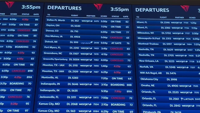
Flight board showing several delays and cancellations at New York's LaGuardia Airport on July 1, 2025.
Heavy rains also triggered flash flooding around Philadelphia, Reading, Baltimore and Washington, D.C., snarling rush hour traffic. Highway lanes were blocked by standing water along Philadelphia's Schuykill Parkway and along Interstate 270 north of Washington.
Baltimore's emergency manager told the National Weather Service there were numerous flooded cars in Fells Point and multiple roads were blocked.
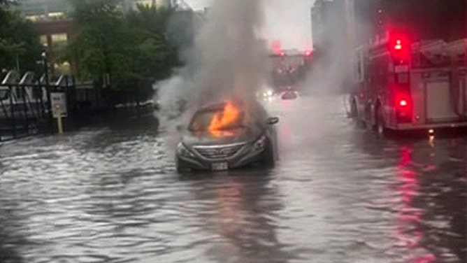
Car catches fire after getting stuck on flooded street in Baltimore on July 1, 2025.
(WBFF-TV / FOX Weather)
Near Reading, storm spotters reported multiple instances of cars trapped in feet of floodwaters. In addition, thunderstorms brought damaging wind gusts near 60 mph that toppled trees onto homes and cars. One tree fell into a home in Oley Furnace, Pennsylvania, trapping some inside the home, the NWS said.
Video from Tuesday afternoon showed cars driving through several inches of floodwater in the streets of northeastern Philadelphia.
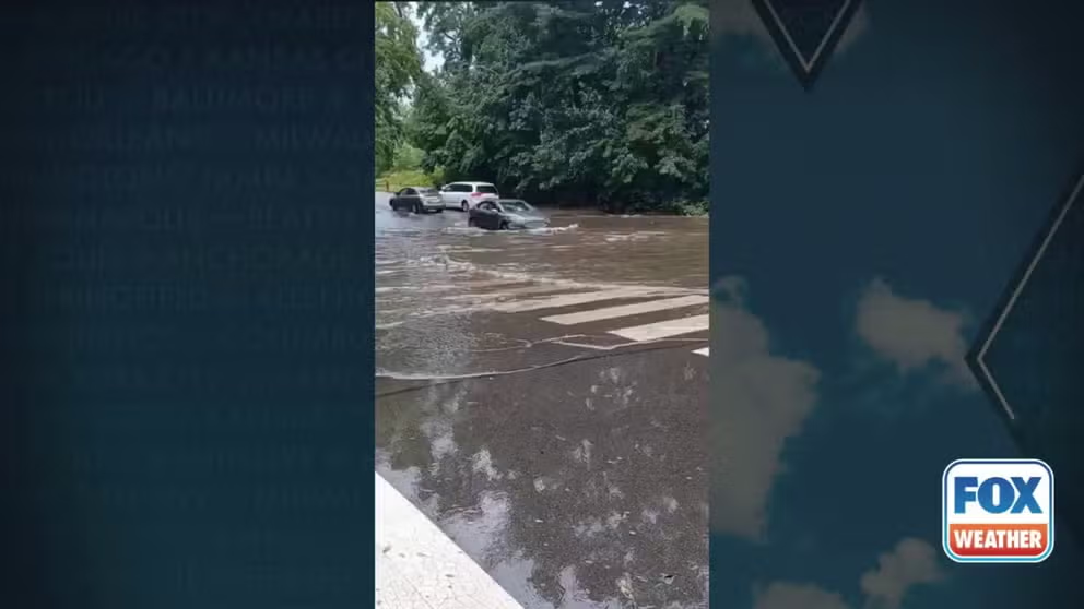
Watch: Cars drive through flooded streets in Philadelphia
Video from Tuesday afternoon showed cars driving through floodwaters in Northeast Philadelphia, Pennsylvania.
In the MLB, both the Philadelphia Phillies and the New York Mets postponed their games on Tuesday evening, citing weather concerns. Both will play double headers on Wednesday to make up the game.

Severe storms lead to major travel delays along I-95 corridor
Major airports in the Northeast are experiencing significant delays due to weather. FOX Weather's Katie Byrne is live in King of Prussia, Pennsylvania, on the latest conditions.
Flash Flood Emergency wreaks havoc in Pennsylvania Monday
On Monday, flash flooding was a huge problem in areas across the Northeast. In Lancaster and Lebanon counties in Pennsylvania, a Flash Flood Emergency was issued about 10:45 p.m. Monday. Local law enforcement reported several water rescues as 4-5 inches of rain was reported.

Roads covered in water near Mountville, Pennsylvania during flash flood emergency
Roads were covered in water near Mountville, Pennsylvania during flash flood emergency late Monday evening.
Lancaster recorded 3.62 inches of rain on Monday, making it the city's 10th-wettest day on record and its eighth-wettest June day.
In addition to the flash flooding, severe storms moved through parts of the Northeast, bringing damaging wind gusts, small hail, lightning strikes to buildings and even a brief tornado. In Sussex County, Delaware, the National Weather Service in Mount Holly, New Jersey, confirmed that a brief, weak tornado swept through, causing some minor tree damage.
DOWNLOAD THE FREE FOX WEATHER APP

Watch: Extremely rare June tornado forms in Delaware
Video from Dagsboro on Monday shows a tornado forming behind a tree link during thunderstorms. The last time a tornado happened in Delaware in June was 2017.
This marks the first tornado reported in Delaware during June since 2017. The First State averages zero tornadoes in the month of June.

Thunderstorms cause flash flooding in Carlisle, Pennsylvania
Thunderstorms caused flash flooding in Carlisle, Pennsylvania on Monday. Cumberland County officials asked drivers to stay off flooded roads.
By Wednesday, the cold front will be moving out, and all storm activity will be over for the bulk of the East Coast. The rest of the week looks to have little to no problems.