Thousands still without power in Northeast as river flooding tops Superstorm Sandy in Philadelphia
The Delaware River in Philadelphia broke an all-time record crest, previously set during Superstorm Sandy, as it rose to 10.66 feet above the low-tide level during high tide at 12:30 a.m. EST Wednesday, according to the National Weather Service.
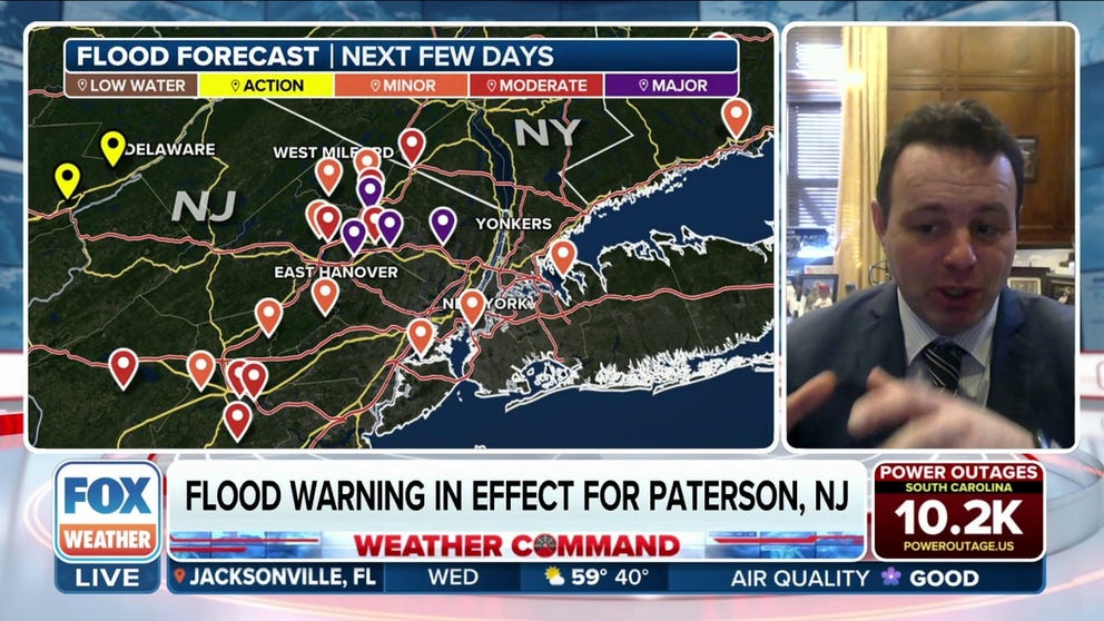
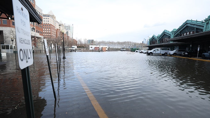
Flood Warning in effect for Paterson, NJ as Passaic River rises
In Paterson, New Jersey, the Passaic River gauge is forecast to reach major flood stage, and a Flood Warning is in effect for the area until Thursday. In December, the river crested at 22 feet, which makes the area particularly vulnerable to the rain this time around. Paterson Mayor Andre Sayegh joins FOX Weather with the latest as a state of emergency is in effect for New Jersey.
POMPTON PLAINS, N.J. – Although the powerful winter storm packing destructive winds and flooding rain in the eastern third of the country is moving into Canada, widespread power outages and significant river flooding are lingering across the Northeast on Wednesday.
Flooding at Hampton Beach, New Hampshire. Jan. 10, 2024.
(henrysweatherchannel)
On Wednesday morning, emergency management in New London County, Connecticut, reported the potential failure of the Fitchville Pond Dam along the Yantic River. Authorities have warned of life-threatening flash flooding in areas downstream from the dam, including the town of Fitchville. The National Weather Service issued a Flash Flood Warning until 6:45 p.m. EST for this area.
Connecticut emergency managers issued a mandatory evacuation of a portion of the nearby town of Bozrah and opened a middle school for shelter.
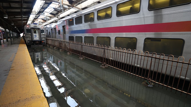
Numerous smaller rivers remain in flood stage, while water levels continue to rise on major area rivers, which will crest in the next 48 hours, the FOX Forecast Center said.
NEW JERSEY RIVERS REACH MAJOR FLOOD STAGE SENDING WATER RUSHING INTO NEARBY COMMUNITIES
More New Jersey rivers expected to reach major flood stage
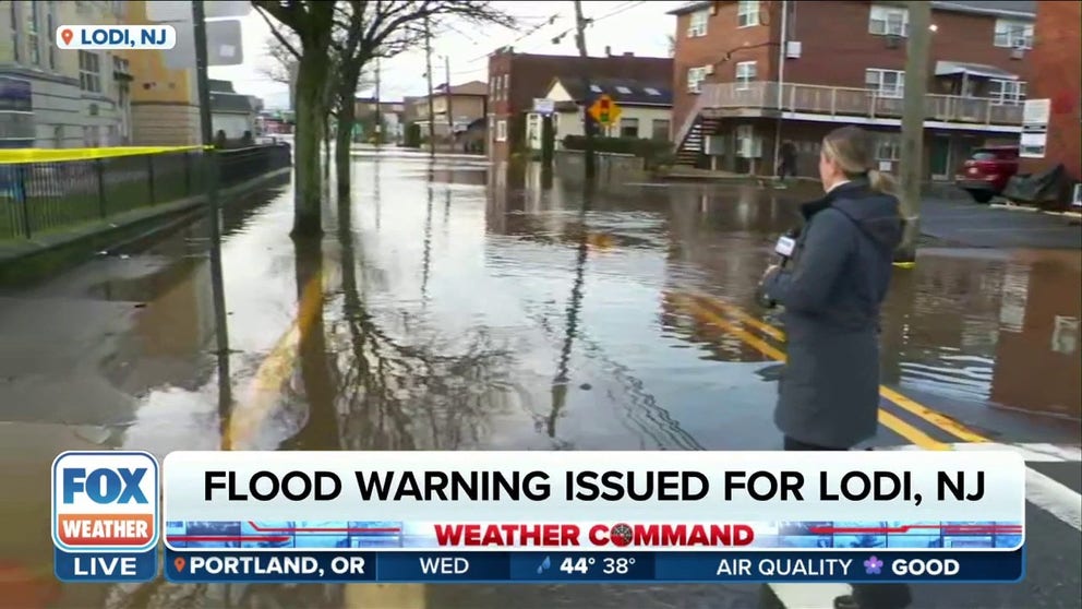
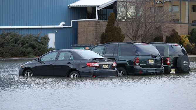
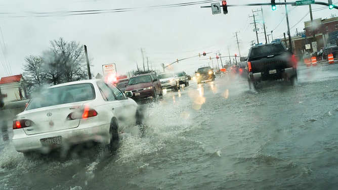
Residents near the Saddle River in Lodi, New Jersey were evacuated on Tuesday after a monster storm caused the river to crest 4 feet above flood level. FOX Weather Correspondent Katie Byrne is on Main Street where the flooding has closed the road.
In Lodi, New Jersey, the Saddle River crested around 9 a.m. Wednesday, more than 2 feet above major flood stage. The river level peaked at 10.27 feet, according to the NWS. The Saddle River enters minor flood stage at 5.5 feet and major flood stage at 8 feet.
Basement and lower-level apartment homes in Lodi were flooded when the river crested, sending water into the streets near the river, including Main Street. Water continued to lap at buildings, and the river raged nearby into Wednesday afternoon.
7 FACTS YOU SHOULD KNOW ABOUT FLOODS
![A view of flooded area after winter storm in New Jersey on January 10, 2024.]() Image 1 of 12
Image 1 of 12A view of flooded area after winter storm in New Jersey on January 10, 2024. (Lokman Vural Elibol/Anadolu)
![A view of flooded area after winter storm in New Jersey on January 10, 2024.]() Image 2 of 12
Image 2 of 12A view of flooded area after winter storm in New Jersey on January 10, 2024. (Lokman Vural Elibol/Anadolu)
![A view of flooded area after winter storm in New Jersey on January 10, 2024.]() Image 3 of 12
Image 3 of 12A view of flooded area after winter storm in New Jersey on January 10, 2024. (Lokman Vural Elibol/Anadolu)
![A view of flooded area after winter storm in New Jersey on January 10, 2024.]() Image 4 of 12
Image 4 of 12A view of flooded area after winter storm in New Jersey on January 10, 2024. (Lokman Vural Elibol/Anadolu)
![A view of flooded area after winter storm in New Jersey on January 10, 2024.]() Image 5 of 12
Image 5 of 12A view of flooded area after winter storm in New Jersey on January 10, 2024. (Lokman Vural Elibol/Anadolu)
![Cars make their way through flooding at the intersection of University Blvd. and New Hampshire Ave. in Langley Park, MD.]() Image 6 of 12
Image 6 of 12Cars make their way through flooding at the intersection of University Blvd. and New Hampshire Ave. in Langley Park, MD. (Sarah L. Voisin/The Washington Post)
![A pedestrian leaps over a puddle at the intersection of Piney Branch Rd. And Flower Ave. in Takoma Park, MD.]() Image 7 of 12
Image 7 of 12A pedestrian leaps over a puddle at the intersection of Piney Branch Rd. And Flower Ave. in Takoma Park, MD. (Sarah L. Voisin/The Washington Post)
![]() Image 8 of 12
Image 8 of 12Strong winds knocked trees down in Alexandria, Virginia. (Alenxandria Police)
![]() Image 9 of 12
Image 9 of 12A 50 mph wind gust blew over an empty tractor trailer on I-90 near Dunkirk, New York Tuesday morning. (New York State Thruway Authority)
![]() Image 10 of 12
Image 10 of 12Downed trees in Washington, D.C. (DC Fire and EMS)
![]() Image 11 of 12
Image 11 of 12Residents use sandbags to protect against flooding in Old Town Alexandria, Virgina. (@gwenfox5dc)
![]() Image 12 of 12
Image 12 of 12Gwen Tobert of FOX 5 DC reporting from flooded Old Town Alexandria, Virginia. (@gwenfox5dc)
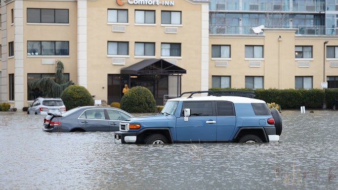


Pompton Plains, New Jersey, has picked up 3-5 inches of rain over the past 24 hours. The Pompton River, which runs through the city, hit major flood stage at 19 feet and is forecast to peak at 20.6 feet by late Wednesday.
"Last night, I was actually outside my house digging trenches to get water away from my foundation," said FOX Weather Meteorologist Britta Merwin as she reported from the flooded Pompton River - an area that experienced moderate to major flooding three weeks ago. "This is something that not only hits close to home, but it's something that a lot of residents are having to deal with across New Jersey and also moving up into Connecticut and upstate New York."
Northeast rain winding down, floodwaters remain
Heavy rain caused flooding in parts of the Northeast Tuesday night into Wednesday morning. The wet weather is expected to continue for a few more hours before it starts to wind down. FOX Weather's Britta Merwin is reporting live from Pompton Plains, New Jersey, with more information on the flooding.
Although the Pompton River reached major flood stage, it won't be a historic event. The highest recorded crest on the Pompton River was during Hurricane Irene in 2011, which reached 25 feet.
"It's not the worst of the worst, but major flooding is major flooding," Merwin said. "Unfortunately, with the river level that we're expecting for crest (Thursday), that means Route 23, which is literally just a stone's throw that way, is going to be impassable for parts."
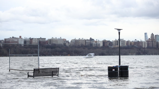
Coastal Flood Warnings and Advisories have been issued by the National Weather Service, with the worst of the coastal flooding forecast to occur in and around the Chesapeake and Delaware bays. At the coast, another dangerous high-tide cycle was expected to send Atlantic waters onto the land during the Wednesday morning high tide.
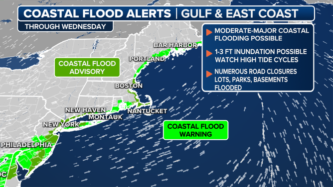
Here's a look at the coastal flood alerts in the Northeast.
(FOX Weather)
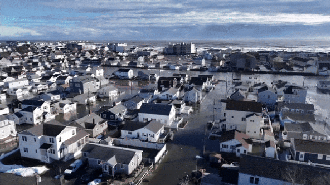
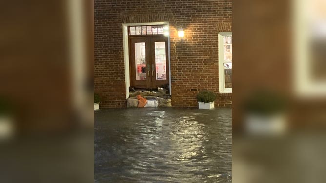
Severe coastal flooding occurred in the Hampton Beach area of New Hampshire. The flooding was caused by heavy rain that poured overnight, accompanied by strong onshore winds that exacerbated the situation.
Hampton police declared an emergency due to extremely high seas and flooding and closed a waterfront boulevard. The town opened an emergency center, and firefighters responded to multiple calls, but no injuries were reported.
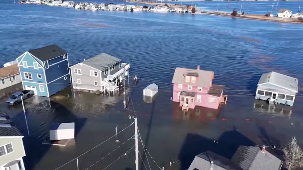
Watch: Major flooding seen over Hampton Beach, NH
An emergency was declared Wednesday morning as a result of extremely high seas and flooding in Hampton, New Hampshire. Drone footage over Hampton Beach shows water creeping up to doorsteps as cars float in driveways.
The Delaware River in Philadelphia broke an all-time record crest, previously set during Superstorm Sandy, as it rose to 10.66 feet above the low-tide level during high tide at 12:30 a.m. EST Wednesday, according to the NWS.
Ahead of the storm, New Jersey Governor Phil Murphy declared a state of emergency for all 21 counties in the state. In Maryland, Governor Wes Moore declared a state of preparedness due to the severe weather conditions. Some school districts decided to dismiss early on Tuesday because of the storm.
Merwin said that the risk of flash flooding has passed as the torrential rain has moved away. However, the wind gusts are still strong, and that's something else residents must be cautious about.
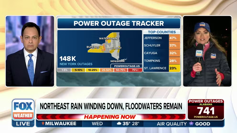
Power slowly being restored
As of last check Wednesday afternoon, more than 300,000 customers were without power from North Carolina through Maine.
DON'T WAIT: NOW IS THE TIME TO PREPARE FOR A POWER OUTAGE
(FOX Weather)
Despite the system exiting into the Atlantic Ocean, strong wind gusts will persist into Wednesday evening in the Northeast, which could trigger additional power outages as crews work tirelessly to restore power to the hundreds of thousands who remain without electricity.
BATTEN DOWN THE HATCHES: WHAT YOU SHOULD KNOW ABOUT HIGH WIND WARNINGS
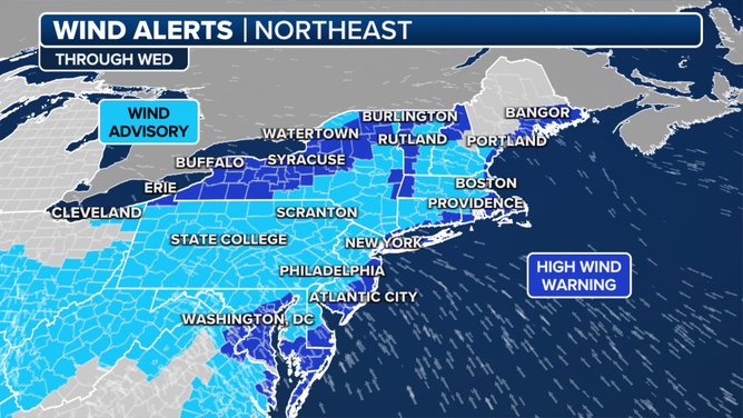
Here's a look at the current wind alerts for the Northeast.
(FOX Weather)
Wind Advisories and High Wind Warnings have been issued for the second straight day across much of the region as winds are forecast to gust between 45 and 60 mph.