Nearly 1 million power outages cripple East Coast as winter storm lashes Northeast
Power outages caused by the high winds are expected to be widespread from coastal New England through portions of the mid-Atlantic, including the I-95 corridor. This includes the Philadelphia, New York City and Boston metro areas.
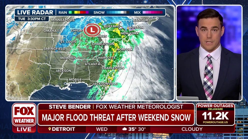
Flooding and 60 mph wind gusts making their way into the I-95 Corridor
FOX Weather is tracking a powerful winter storm that already paralyzed the Plains with a blizzard and spawned deadly tornadoes in the South. Now the storm is soaking the Mid-Atlantic and Northeast. 40-60 mph wind gusts are creating an airport nightmare and knocking out power.
PHILADELPHIA – Another powerful storm system lashed the Northeast, with coastal flooding and damaging winds that produced nearly a million power outages New England through the mid-Atlantic states.
The storm also snarled travel in the central U.S. after blizzard conditions blasted the Plains and produced damaging thunderstorms and tornadoes that ravaged the Southeast. Now, it brings soaking rain and high winds to much of the Northeast, along with accumulating snow over interior portions of the region before an eventual changeover to rain and melting all that snow.
![]() Image 1 of 5
Image 1 of 5Strong winds knocked trees down in Alexandria, Virginia. (Alenxandria Police)
![]() Image 2 of 5
Image 2 of 5A 50 mph wind gust blew over an empty tractor trailer on I-90 near Dunkirk, New York Tuesday morning. (New York State Thruway Authority)
![]() Image 3 of 5
Image 3 of 5Downed trees in Washington, D.C. (DC Fire and EMS)
![]() Image 4 of 5
Image 4 of 5Residents use sandbags to protect against flooding in Old Town Alexandria, Virgina. (@gwenfox5dc)
![]() Image 5 of 5
Image 5 of 5Gwen Tobert of FOX 5 DC reporting from flooded Old Town Alexandria, Virginia. (@gwenfox5dc)


Damaging winds could knock out power for millions in eastern US
(FOX Weather)
"I'm very concerned about this," Niziol said. "This combination of very strong winds and a plume of very heavy moisture coming up along the Eastern Seaboard is going to spell real issues for power outages."
New Hampshire Governor Chris Sununu announced that Granite State power companies brought in extra resources in advance of the storm.
High Wind Warnings and Wind Advisories were issued into Wednesday for nearly the entire region.
Areas along the coast experienced winds around hurricane force (74 mph or higher). Hurricane-Force Wind Warnings are even posted offshore of Downeast Maine, where gusts over the ocean could reach 80 mph.

Listen: Winds roar through Wall Street in New York City
Just in time for the commute home, the wind roared through Wall Street in New York City.
BATTEN DOWN THE HATCHES: WHAT YOU SHOULD KNOW ABOUT HIGH WIND WARNINGS
"Wednesday morning, in particular, along the coastal regions of the mid-Atlantic right up through Downeast Maine, we could see wind gusts in excess of 60 mph," Niziol said. "So I'm very concerned about this timeframe here and potential big impacts from widespread power outages in that Tuesday-to-Wednesday timeframe."
DON'T WAIT: NOW IS THE TIME TO PREPARE FOR A POWER OUTAGE

(FOX Weather)
Dangerous flooding threat for Northeast, including Washington, Philadelphia and suburbs of New York City
Rain will continue overspreading the mid-Atlantic and Northeast through Wednesday morning and quickly become heavy at times, prompting NOAA's Weather Prediction Center to issue a Level 3 out of 4 risk for flooding in parts of the region (shaded in yellow on the map below).

(FOX Weather)
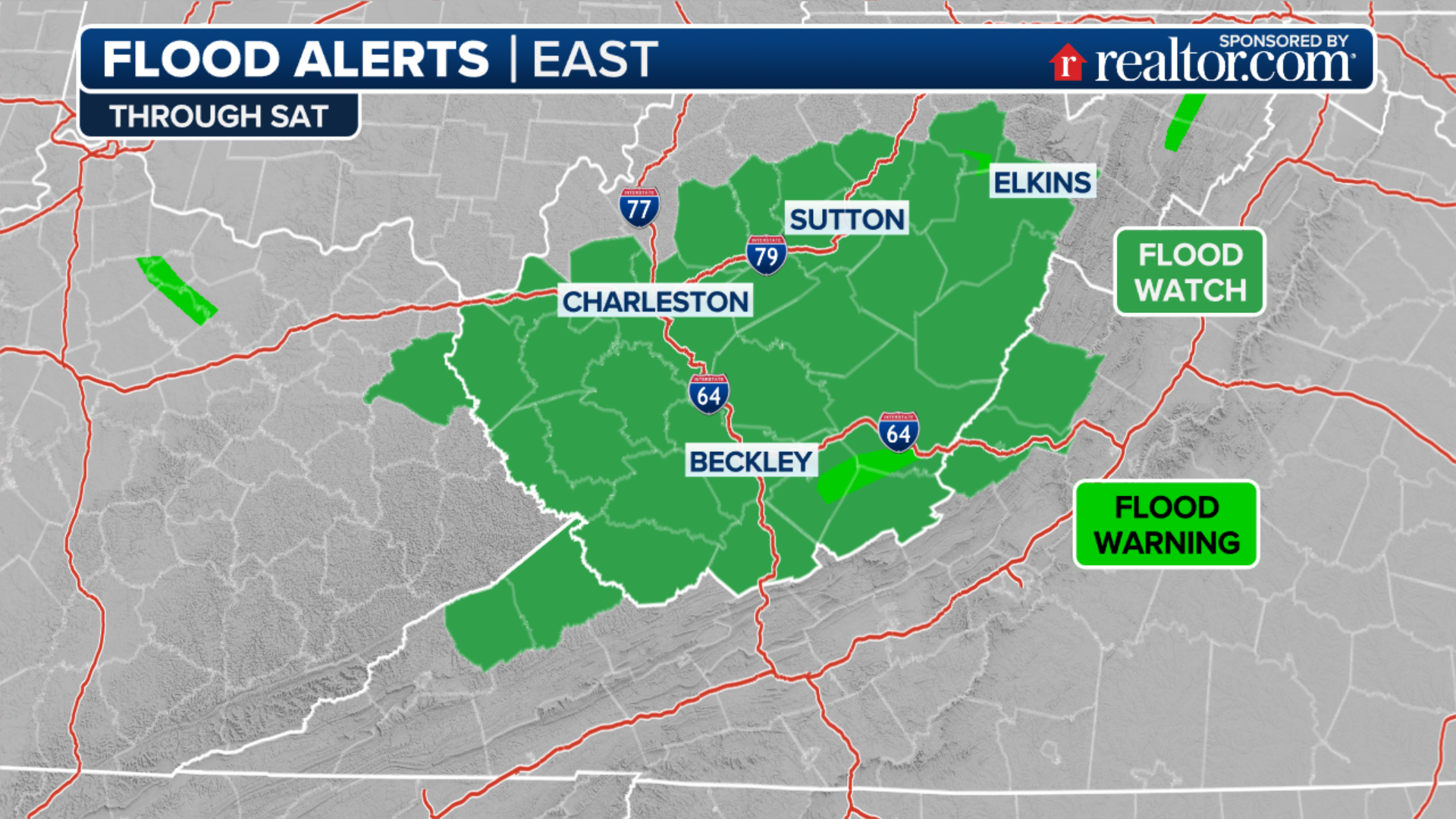
The Level 3 risk stretches from parts of Virginia and Maryland through eastern Pennsylvania, central and northern New Jersey, the lower and mid-Hudson Valley of New York, Connecticut, Rhode Island, and southern Massachusetts. This risk covers more than 32 million people and includes Washington, Baltimore, Philadelphia and the northern and western suburbs of New York City.
The National Weather Service has issued Flood Watches for a large portion of the Northeast because of the threat of heavy rain leading to flash flooding. These Flood Watches stretch from southern Maine through Georgia.
7 FACTS YOU SHOULD KNOW ABOUT FLOODS
(FOX Weather)
How much rain is expected?
Moisture rushing in from the Atlantic Ocean will fuel the heavy rain threat in the mid-Atlantic and Northeast on Tuesday and Tuesday night. In most areas, the heaviest rain will fall overnight Tuesday into early Wednesday morning before tapering to showers from west to east on Wednesday.
Widespread rainfall totals between 1 and 3 inches are expected across the region before the rain pushes off the East Coast. This includes Washington, Baltimore, Philadelphia, New York City and Boston.
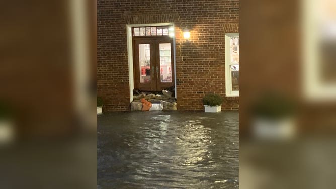
Residents use sandbags to protect against flooding in Old Town Alexandria, Virgina.
(@gwenfox5dc / FOX 5 DC)
Locally higher amounts, upwards of 3-5 inches, are possible in parts of northern New Jersey, the lower Hudson Valley of New York and southern New England.
By early evening, Doppler radar estimated that areas around Rehoboth, Virginia, already got 3-4 inches of rain with another inch possibly to come.
New Jersey Governor Phil Murphy declared a state of emergency through Wednesday.
"We are expecting one to four inches of heavy rain, strong winds, and potential inland and coastal flooding," Murphy said in a statement. "This storm will exacerbate the effects of the inclement conditions we experienced in December and this past weekend and may precede another storm Friday night."
This heavy rain will fall on top of a fresh snowpack in parts of the interior Northeast and New England after a nor'easter dumped several inches of snow across the region over the weekend. The melting snow will only add to the flooding concerns this week.

(FOX Weather)
Once the rain ends on Wednesday, the flood threat will not. Instead, it will shift from a flash flood to a river flood threat.
Dozens of rivers, creeks and streams are expected to rise into flood stage, and multiple may reach moderate to perhaps major flooding. While every storm is different, the setup for this river flood threat is similar to the one that led to destructive river flooding across the Northeast following the deadly Dec. 18-19 East Coast storm.
Coastal flooding also a concern for the Northeast, mid-Atlantic
Along the Atlantic coastline, powerful onshore winds will lead to widespread coastal flooding from North Carolina to Maine during times of high tide.

(FOX Weather)
Coastal Flood Warnings have been issued by the National Weather Service, with the worst of the coastal flooding forecast to occur in and around the Chesapeake and Delaware bays.