Powerful winter storm packs heavy snow, flooding, severe storm threats as it pummels East Coast
A powerful storm is bringing snow, flooding and severe weather to the U.S. this week. Heavy snow conditions are likely in the Great Lakes, with severe storms and power outages expected in the South and East.
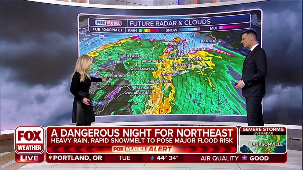
Northeast bracing for flooding and mass power outages
FOX Weather is tracking a powerful storm as it lifts out of the South and triggers wind gusts to 50-plus mph knocking trees into power lines. Forecast heavy rains prompted areas of New Jersey, anticipating flooding, to open shelters. FOX Weather's Katie Byrrne takes us to the Garden State.
After an active weekend in the Northeast, another major winter weather system is moving across the central and eastern U.S., bringing blizzard conditions, severe weather, flooding and widespread power outages.
And the East Coast isn't the only one seeing active weather this week; 49 of the 50 states were under some type of weather alert on Tuesday. North Dakota was the only state not included in any watches, warnings or advisories issued by the National Weather Service.
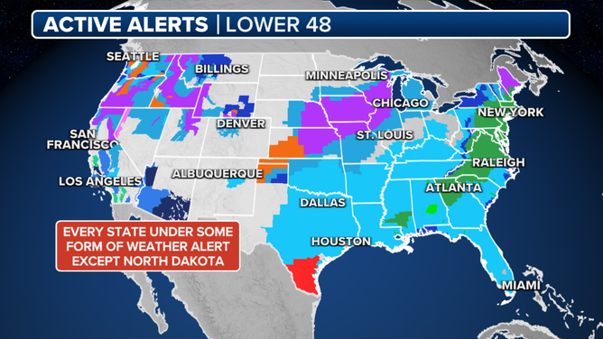
North Dakota was the only U.S. state not under some type of weather alert on Monday, Jan. 8, 2024.
(FOX Weather)
Here are the latest impacts and timing for the winter weather system slamming the eastern U.S.
Blizzard pummels the central Plains; heavy snow eyes Great Lakes
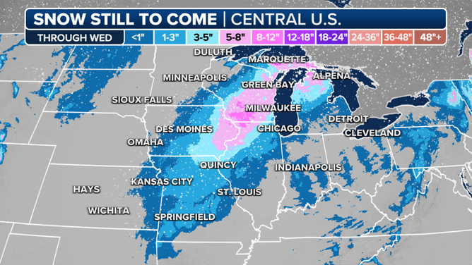
Snow forecast through Wednesday, Jan. 10, 2024
(FOX Weather)
Winter is awakening. A day after Blizzard Warnings covered parts of the Plains, Winter Storm Warnings now cover parts of eight states in the Upper Midwest and into the Great Lakes from Kansas through Illinois, Wisconsin and Michigan.
Strong winds will also accompany the snow, limiting visibility with blowing snow.
As cold air wraps around this low-pressure system, snow forecast totals reach 5-8 inches in northern Illinois and southeastern Wisconsin and up to a foot in a few isolated areas where snow bands set up.
Click here for the latest on the snow threat.
Tornadoes cause damage in the Southeast
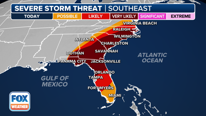
Severe weather outlook for Tuesday, Jan. 9, 2024
(FOX Weather)
Severe weather slammed the Southeast from Monday night into Tuesday morning with multiple apparent tornadoes in the Florida Panhandle.
Dozens of Tornado Warnings, including many with Doppler radar-confirmed tornadoes, have been reported across the region since late Monday, and that number will likely increase throughout the day as thunderstorms race eastward at speeds of up to 70 mph.
Florida's Bay County and Walton County appear to have been especially hard hit by storms.

Major damage is seen at what appears to be an apartment building in Bay County, Florida, on Tuesday, Jan. 9, 2024.
(Bay County Sheriff’s Office/Facebook)
The severe thunderstorm threat is spreading north and east into Tuesday afternoon and evening, with Tornado Watches stretching from Florida to North Carolina. With strong wind shear and abundant moisture available, conditions remain favorable for damaging winds, hail and tornadoes – some perhaps stronger than EF-2.
In addition to the threat of severe weather, heavy rain will lead to an increased risk of flash flooding across the entire Southeast.
Click here for a more detailed forecast for this week’s severe weather and flooding threats.
Widespread power outages, flooding possible in Northeast
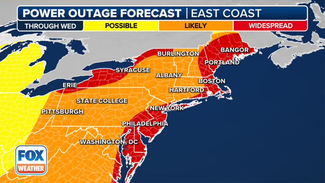
The power outage forecast for the Northeast.
As the system continues to track eastward through the U.S., the storm will bring heavy rain and strong winds to the Northeast on Tuesday and Wednesday.
With an already-saturated ground and several inches of snowpack across the interior after a weekend nor'easter, the heavy rain combined with strong winds could lead to downed trees and power lines, resulting in widespread power outages.
Strong winds will last through Wednesday as the system exits the region.
Click here for the latest threat of flooding and power outages in the Northeast.