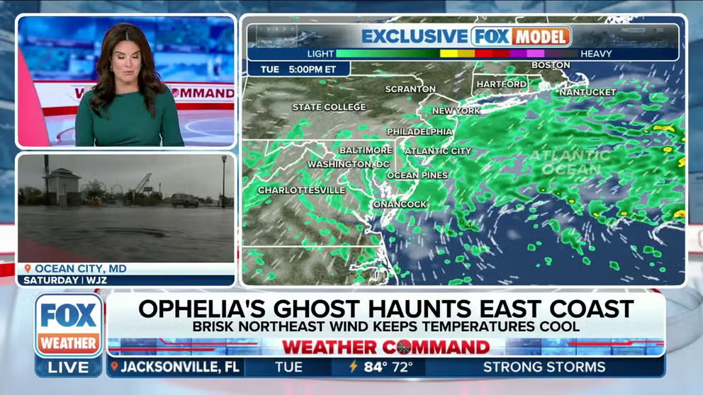
Ophelia's remnants continue bringing leftover rain, wind to millions in the Northeast but relief is coming
Ophelia made landfall in North Carolina early Saturday morning as a strong tropical storm and caused widespread flooding and power outages from the mid-Atlantic to the Northeast. The storm's remnants continue to bring gusty winds and rain showers to the Northeast and New England on Tuesday.
Coastal flooding still a concern in the Northeast, mid-Atlantic as Ophelia's remnants continue to spin offshore
The remnants of Ophelia are continuing to cause issues, and as the system spins offshore there are more concerns of coastal flooding from the mid-Atlantic to the Northeast.
BOSTON – The Northeast will need to endure one more day of wet, gloomy weather before conditions begin to improve thanks in part to the remnants of what was once Tropical Storm Ophelia that continue to spin across the region.

Watch: Time-lapse video shows storm surge flooding New Bern, North Carolina
Time-lapse video recorded in New Bern, North Carolina, shows how high the storm surge got when then Tropical Storm Ophelia approached the region. Flooding was reported up and down the mid-Atlantic coast as the storm made landfall on Saturday, September 24, 2023.
Central Park, the National Weather Service's official recording site for New York City, has reported three consecutive days of rain while the Northeast, in general, is now on day five of less-than-ideal weather conditions.
It’s been cloudy. It’s been wet. It’s been dreary. Millions of people across the region are ready for a change but will have to wait just a little longer.
Improvements coming in the Northeast, New England
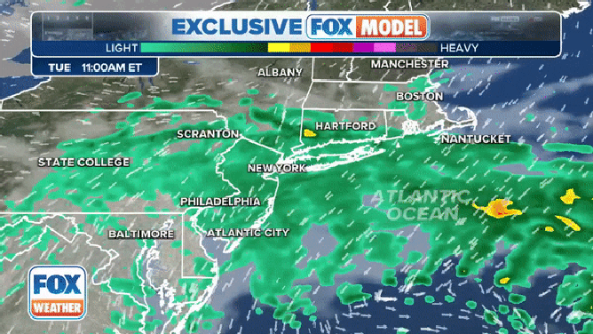
The exclusive FOX Model showing weather conditions through Wednesday, September 27, 2023.
(FOX Weather)
Widespread rain continues for hundreds of miles across the Northeast, but most of it is just misty rain that’s more of an annoyance rather than something that will cause major problems on the roads or in rivers and streams.
However, there has been some steadier rain in western and central Pennsylvania, which made for a slower morning commute in those areas.

(FOX Weather)
The FOX Forecast Center isn't expecting much in terms of rainfall totals through Wednesday afternoon and evening. Most areas that do see additional rain will pick up less than a half-inch.
But there's another component that could continue to cause problems in the region: wind.
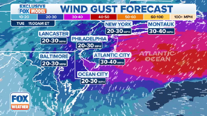
A look at the forecast wind gusts through Wednesday, September 27, 2023.
(FOX Weather)
Winds have been gusting to between 20 and 30 mph in places like Montauk, New York, and Nantucket, Massachusetts.
"The big concern with some of these winds is going to be the fact that we have saturation of the ground," FOX Weather meteorologist Jason Frazer said. "And once you get some of the stronger wind gusts, we can end up seeing some trees being knocked down today."
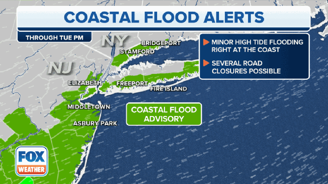
Coastal flood alerts in effect in the Northeast and New England through Tuesday, September 26, 2023.
(FOX Weather)
Coastal flooding is also a concern across the Northeast and for portions of New England.
"This is an onshore wind, which means coastal flooding," FOX Weather meteorologist Britta Merwin said. "New Jersey, Delaware. This is a shoreline that doesn’t take onshore winds very well."
Conditions are likely to start to improve by Wednesday, when sunshine will begin to return to areas of the Northeast and New England that have seen days of dreary weather conditions.
Flooding leads to water rescues in mid-Atlantic
![CRISFIELD, MD - SEPTEMBER 24: A vehicle moves through a flooded intersection following heavy rains from Tropical Storm Ophelia on September 24, 2023 in Crisfield, Maryland. Ophelia made landfall early Saturday in North Carolina, producing high winds and heavy rain across the Carolinas, Virginia, Maryland, Delaware, and New Jersey. The city of Crisfield will apply for Federal Emergency Management Agency and Maryland Department of Emergency Management grants to help pay for a $63 million flood control program to mitigate flooding by raising roads, and building new tide gates, berms, and other projects.]() Image 1 of 22
Image 1 of 22CRISFIELD, MD - SEPTEMBER 24: A vehicle moves through a flooded intersection following heavy rains from Tropical Storm Ophelia on September 24, 2023 in Crisfield, Maryland. Ophelia made landfall early Saturday in North Carolina, producing high winds and heavy rain across the Carolinas, Virginia, Maryland, Delaware, and New Jersey. The city of Crisfield will apply for Federal Emergency Management Agency and Maryland Department of Emergency Management grants to help pay for a $63 million flood control program to mitigate flooding by raising roads, and building new tide gates, berms, and other projects. (Chip Somodevilla)
![CRISFIELD, MD - SEPTEMBER 24: In this aerial view, the Chesapeake Bay stretches out past the downtown area following two days of heavy rain from Tropical Storm Ophelia on September 24, 2023 in Crisfield, Maryland. Ophelia made landfall early Saturday in North Carolina, producing high winds and heavy rain across the Carolinas, Virginia, Maryland, Delaware, and New Jersey. The city of Crisfield will apply for Federal Emergency Management Agency and Maryland Department of Emergency Management grants to help pay for a $63 million flood control program to mitigate flooding by raising roads, building new tide gates, berms, and other projects.]() Image 2 of 22
Image 2 of 22CRISFIELD, MD - SEPTEMBER 24: In this aerial view, the Chesapeake Bay stretches out past the downtown area following two days of heavy rain from Tropical Storm Ophelia on September 24, 2023 in Crisfield, Maryland. Ophelia made landfall early Saturday in North Carolina, producing high winds and heavy rain across the Carolinas, Virginia, Maryland, Delaware, and New Jersey. The city of Crisfield will apply for Federal Emergency Management Agency and Maryland Department of Emergency Management grants to help pay for a $63 million flood control program to mitigate flooding by raising roads, building new tide gates, berms, and other projects. (Chip Somodevilla)
![ANNAPOLIS, MD - SEPTEMBER 23: Lisa Banting of Annapolis braves the elements to get a snapshot of the waves at Sandy Point Beach as Tropical Storm Ophelia moves northward through the Mid-Atlantic this weekend dropping heavy rain and high winds on September 23, 2023.]() Image 3 of 22
Image 3 of 22ANNAPOLIS, MD - SEPTEMBER 23: Lisa Banting of Annapolis braves the elements to get a snapshot of the waves at Sandy Point Beach as Tropical Storm Ophelia moves northward through the Mid-Atlantic this weekend dropping heavy rain and high winds on September 23, 2023. (Jonathan Newton/The Washington Post)
![A home health aide walks to her client's home along the flooded Cove Street following two days of heavy rain from Tropical Storm Ophelia on September 24, 2023 in Crisfield, Maryland.]() Image 4 of 22
Image 4 of 22A home health aide walks to her client's home along the flooded Cove Street following two days of heavy rain from Tropical Storm Ophelia on September 24, 2023 in Crisfield, Maryland. (Chip Somodevilla)
![A Stone Harbor, New Jersey, resident needed some assistance from police and fire/rescue after a street was flooded during Tropical Storm Ophelia.]() Image 5 of 22
Image 5 of 22A Stone Harbor, New Jersey, resident needed some assistance from police and fire/rescue after a street was flooded during Tropical Storm Ophelia. (@Zeke_O / X)
![]() Image 6 of 22
Image 6 of 22Washington, NC after Ophelia. (Weather Chasing via Storyful)
![]() Image 7 of 22
Image 7 of 22Washington, NC after Ophelia. (Weather Chasing via Storyful)
![]() Image 8 of 22
Image 8 of 22Washington, NC after Ophelia. (Weather Chasing via Storyful)
![]() Image 9 of 22
Image 9 of 22Washington, NC after Ophelia. (Weather Chasing via Storyful)
![]() Image 10 of 22
Image 10 of 22Washington, NC after Ophelia. (Weather Chasing via Storyful)
![]() Image 11 of 22
Image 11 of 22Washington, NC after Ophelia. (Weather Chasing via Storyful)
![Flooding in Delaware]() Image 12 of 22
Image 12 of 22Flooding in Dewey Beach, Delaware (DEDOT)
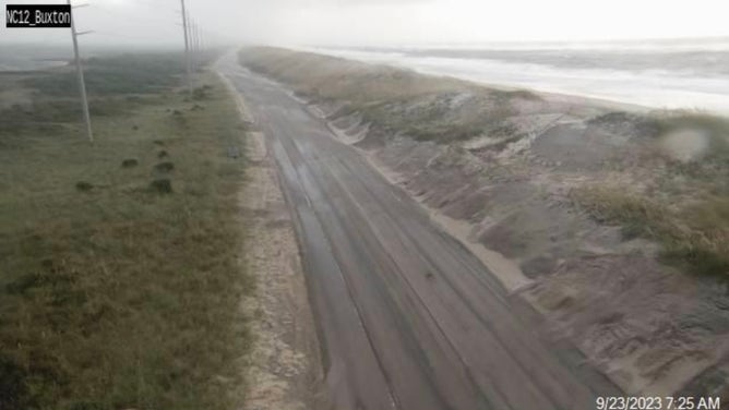
![North Carolina SR 12 on Saturday, Sept. 23, 2023.]() Image 13 of 22
Image 13 of 22North Carolina SR 12 on Saturday, Sept. 23, 2023. (NCDOT NC 12)
![Large tree falls in Deal, New Jersey during Tropical Storm Ophelia]() Image 14 of 22
Image 14 of 22Large tree falls in Deal, New Jersey during Tropical Storm Ophelia. (@MDCArtSpace)
![Large tree falls in Deal, New Jersey during Tropical Storm Ophelia]() Image 15 of 22
Image 15 of 22Large tree falls in Deal, New Jersey during Tropical Storm Ophelia. (@MDCArtSpace)
![Brandy Campbell at Cape Hatters on Saturday morning.]() Image 16 of 22
Image 16 of 22Brandy Campbell at Cape Hatters on Saturday morning. (Brandy Campbell)
![Tropical Storm Ophelia impacts]() Image 17 of 22
Image 17 of 22Tropical Storm Ophelia impacts St. Marys County, Maryland. (St. Marys County Sheriff's Office)
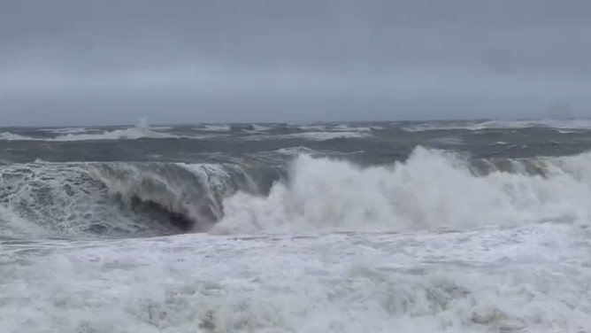
![Surfers ride the waves as the ocean is whipped up by Tropical Storm Ophelia at Wrightsville Beach on September 23, 2023 in Wilmington, North Carolina.]() Image 18 of 22
Image 18 of 22Surfers ride the waves as the ocean is whipped up by Tropical Storm Ophelia at Wrightsville Beach on September 23, 2023 in Wilmington, North Carolina. (Eros Hoagland)
![Storm surge flooding could be seen in Washington, North Carolina, on Saturday. Tropical Storm Ophelia is lashing the mid-Atlantic with gusty winds and dangerous storm surge as it charges up the East Coast.]() Image 19 of 22
Image 19 of 22Storm surge flooding could be seen in Washington, North Carolina, on Saturday. Tropical Storm Ophelia is lashing the mid-Atlantic with gusty winds and dangerous storm surge as it charges up the East Coast. (Mark Sudduth)
![An angry ocean is seen on the Delaware coast on Saturday morning following Tropical Storm Ophelias landfall in Emerald Isle, North Carolina.]() Image 20 of 22
Image 20 of 22An angry ocean is seen on the Delaware coast on Saturday morning following Tropical Storm Ophelias landfall in Emerald Isle, North Carolina. ( )
![Coastal flooding seen on North Pennsylvania Avenue in Bethany Beach, Delaware, on Saturday.]() Image 21 of 22
Image 21 of 22Coastal flooding seen on North Pennsylvania Avenue in Bethany Beach, Delaware, on Saturday. (@KnaptonOliver via X)
![A pine tree fell in the Greenbrier neighborhood in New Bern, North Carolina, on Saturday.]() Image 22 of 22
Image 22 of 22A pine tree fell in the Greenbrier neighborhood in New Bern, North Carolina, on Saturday. (Mark Sudduth)


Ophelia made landfall near Emerald Isle, North Carolina, early Saturday morning as a strong tropical storm and caused widespread flooding and power outages from the mid-Atlantic to the Northeast. The storm then pushed farther inland later Saturday and into Sunday.
Coastal communities were flooded as Ophelia spun across the region, with the U.S. Coast Guard announcing it rescued five people on Friday from an anchored catamaran in Cape Lookout, North Carolina.
The Coast Guard said the group, which included three children, were on the moored vessel when the conditions on the water became dangerous.
Seas were reported to be about 6 to 8 feet, and winds were blowing just below tropical storm force when the rescue occurred.
COAST GUARD RESCUES 5 BOATERS FROM OUTER BANKS DURING OPHELIA
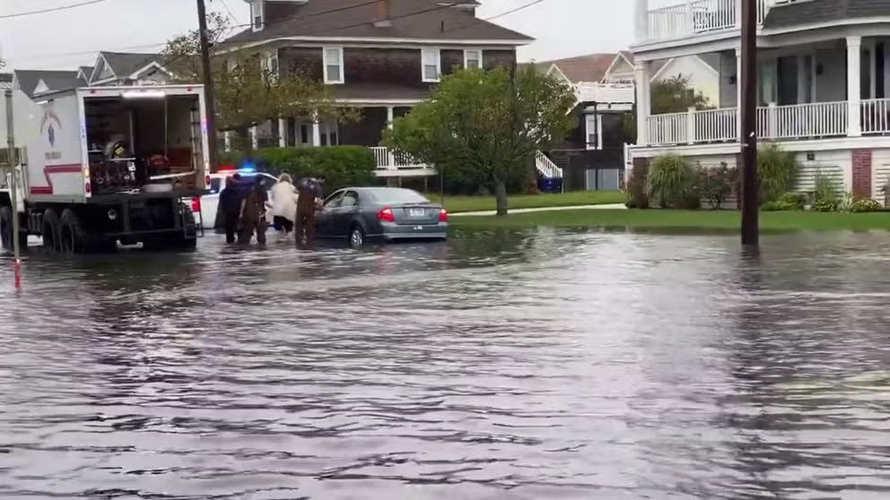
New Jersey street flooding from Ophelia
The combination of rainfall and high tides caused street flooding in Stone Harbor, New Jersey.
Despite pleas from first responders to stay home during the storm, some drivers who decided to venture out needed help after getting vehicles stuck in floodwaters.
At least one driver in Stone Harbor, New Jersey, needed help after getting stuck, and video from the area showed the roadway covered with water and high-water vehicles assisting during the rescue.
The fierce winds also caused more than 70,000 power outages during the height of the storm in the mid-Atlantic. Crews have been out in full force working to restore power, and data from PowerOutage.us shows most people have been brought back online.
Floodwaters being pumped into the ocean near Ophelia's landfall location
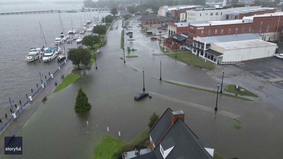
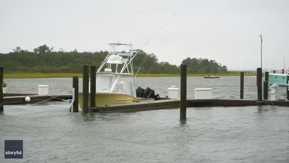
Aerial video show powerful storm surge from Ophelia in North Carolina
Drone video recorded in Washington, North Carolina shows the city's boardwalk and marina covered in flood waters on Saturday hours after Tropical Storm Ophelia made landfall. (Video: Weather Chasing via Storyful)
Ophelia made landfall near Emerald Isle around 6:15 a.m. Saturday with maximum sustained winds of about 70 mph – just shy of reaching hurricane strength.
North Carolina's Department of Environmental Quality issued an alert on Sunday warning swimmers and surfers to stay out of the water in Emerald Isle because floodwaters from the storm are being pumped into the ocean surf in the region.
Officials said the decision to pump floodwaters into the ocean was made to minimize flood damage and to ensure roads are accessible for emergency vehicles.
Ophelia's storm surge causes flooding in coastal North Carolina
Strong winds and storm surge were impacting Atlantic Beach in North Carolina on Saturday morning, September 23, after Tropical Storm Ophelia made landfall about 10 miles west, near Emerald Isle, at around 6:15 am.
"These waters can contain pollutants such as waste from wildlife and pets, oil and gasoline from parking lots and waste from septic systems or sewers," officials warned in a news release.
Officials said signs will be placed at discharge sites along the ocean beach to warn the public about possible health risks.
Those notices do not imply that disease-causing organisms are present in the water but identify an increased chance that contamination and adverse health effects could occur.
Signs will be removed from the area 24 hours after pumping stops, officials said.