Heavy rain, gusty winds put millions on alert across Northeast
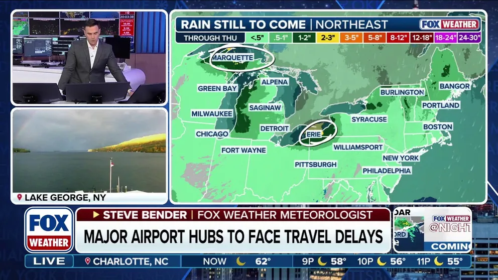
The heaviest rain was expected to fall between Sunday night and Monday morning, with widespread rainfall totals of 1-2 inches likely across interior portions of the Northeast and northern New England. Those areas are currently experiencing extreme drought conditions.
Stormy week shaping up in the east
FOX Weather Meteorologist Steve Bender breaks down the latest updates for this week in the east, as residents can expect a stormy week ahead.
NEW YORK – A powerful cold front sweeping across the Northeast has been bringing some heavy rain and gusty winds to the region, and the FOX Forecast Center says that’s the start of an active weather pattern shaping up for millions from the Great Lakes to New England.
This latest round of wet weather comes on the heels of a dayslong nor’easter that slammed communities along the East Coast last week.

(FOX Weather)
The FOX Forecast Center said that as this first system progresses eastward, its trailing cold front has been bringing the messy weather to millions along the Interstate 95 corridor as of Monday morning.
There was even a low-end tornado threat in cities like Philadelphia and New York City overnight and into early Monday. Luckily, there haven’t been any reports of twisters in the Northeast.
Forecasters say that while the main area of low pressure lifts off into Canada, another area of low pressure is expected to develop closer to the Northeast coast, which could enhance some rain totals and lead to flash flooding and coastal flooding.
DOWNLOAD THE FREE FOX WEATHER APP

(FOX Weather)
The heaviest rain was expected to fall between Sunday night and Monday morning, with widespread rainfall totals of 1-2 inches likely across interior portions of the Northeast and northern New England. Those areas are currently experiencing extreme drought conditions.
The FOX Forecast Center said localized rainfall totals of 2 to even 3 or more inches are also possible, and NOAA’s Weather Prediction Center placed parts of Vermont, New Hampshire and Maine in a Level 1 out of 4 threat of flash flooding on Monday.
Behind this storm system, another one looks to move out of the Great Lakes and into portions of the Northeast by Tuesday as the more active weather pattern begins.
The Great Lakes and Northeast will be locked in a dreary, wet pattern through at least the first half of the week, with the FOX Forecast Center predicting lake-effect showers and maybe even some snow could fall near the Upper Peninsula of Michigan from Wednesday into Thursday.