Storms barrel across Great Lakes with another fast-moving system expected to sweep across the region this week
A majority of the Lower 48 is experiencing above-average temperatures this week, so as the storm moves from the Great Lakes and into the Northeast, most of the cold air is centered across Canada and bringing mostly cool rain to millions in the U.S.

Clipper systems to bring wet, windy weather from Great Lakes to Northeast
A series of potent but fast-moving clipper systems is bring west and stormy weather to the Great Lakes on Monday before it pushes into the Northeast on Monday night and Tuesday. Then another storm sweeps in from Canada and moves across the same regions starting on Tuesday and lasting through Thursday.
Quick-hitting storms will continue to barrel across the Great Lakes and Northeast this week, bringing threats of snow, ice and cold rain to the regions.
The first round of thunderstorms packed heavy rain and hail as it traveled across the Great Lakes on Monday morning.
The storms swept across Michigan at about 50 mph and even sparked some severe thunderstorm warnings over the past several hours.
A majority of the Lower 48 is experiencing above-average temperatures this week, so as the storm moves from the Great Lakes and into the Northeast, most of the cold air is centered across Canada and bringing mostly cool rain to millions in the U.S.

(FOX Weather)
Generally, about 1-2 inches of rain can be expected from these clipper systems.
"But in this weather pattern, with a more of a west-to-east zonal flow, you get multiple disturbances like this," FOX Weather Meteorologist Ian Oliver said.

(FOX Weather)
That means another storm system will be moving into the Northern Tier and Upper Midwest during the day on Tuesday.
"This one has a touch more cold air to work with, that’s why you notice as we move into the middle part of the week, you do see a little bit of mixed precipitation and even some snow showers mixing in across the same areas," Oliver continued.
CHANCES TO SPOT NORTHERN LIGHTS INCREASING FOR NORTHERN US THIS WEEK
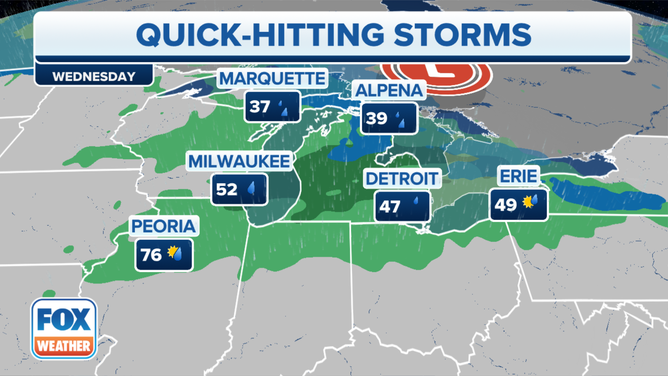
The weather forecast on Wednesday, November 8, 2023.
(FOX Weather)
Impacts to the Northeast
As we get into the middle of the workweek and Thursday, the storm system will race across the Great Lakes and into the Northeast and New England.
"Most of (the precipitation) is just a cool rain," Oliver said. "But as we get into northern parts of New England, we are expecting some snow in the northern parts of the Adirondacks, the Green Mountains and the White Mountains."
A ROYAL ‘BROLLY’: QUEEN'S LOVE OF UMBRELLAS SHELTERED HER HUMBLE STYLE
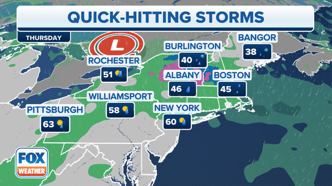
The weather forecast on Thursday, November 9, 2023.
(FOX Weather)
There’s also the potential for a glaze of ice that won’t have much of an impact but will slow down those traveling on the region’s roads and highways.
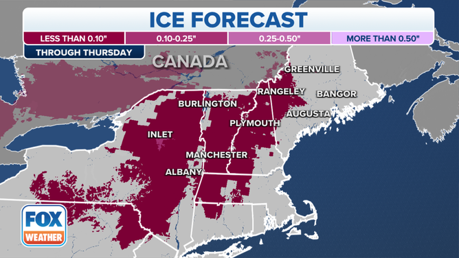
The ice forecast through Thursday, November 9, 2023.
(FOX Weather)
"Less than a tenth of an inch is possible," Oliver said. "But you do notice up in the Hudson Valley and eventually into the Green Mountain State, the White Mountains, and into Maine, we’ll have to watch for that. Particularly later Wednesday and into Thursday for some travel impacts across northern parts of the region."