Flood threat wanes in Helene-ravaged western North Carolina; tornado causes damage in South Carolina
In South Carolina, the National Weather Service office in Columbia said parts of the state were rocked by a high-end EF-1 tornado early Monday morning. According to information provided by the NWS, the tornado touched down in the Aiken County community of Langley just before 3:30 a.m. ET.

Flooding impacts some Helene-ravaged communities in wester North Carolina
Torrential rain flooded parts of Helene-ravaged western North Carolina on Monday, but the impact wasn’t anywhere near what was experienced during the deadly disaster. FOX Weather Correspondent Robert Ray was in Asheville with the latest on Tuesday, May 13.
ASHEVILLE, N.C. – The flood threat across portions of Helene-ravaged western North Carolina is starting to wane on Tuesday morning after the region was put on alert due to torrential rain and severe weather that also produced a tornado in South Carolina.
The FOX Forecast Center said the threats came from the same system that brought flooding rain and severe weather, including reports of tornadoes and waterspouts, to cities along the Gulf Coast over the weekend.
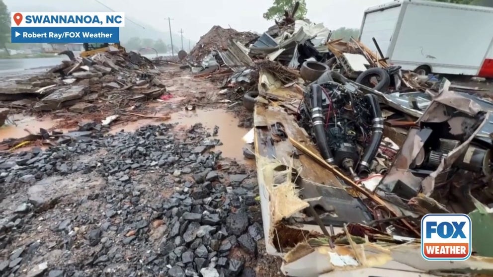
Heavy rain falls on Helene debris in Western North Carolina
Video from FOX Weather Correspondent Robert Ray shows heavy rain falling on flooding debris from Hurricane Helene in Swannanoa, North Carolina, more than 8 months after the historic flooding event.
The FOX Forecast Center said that after lingering over the Southeast over the weekend, a stubborn area of low pressure finally started lifting into the Tennessee Valley, bringing more rounds of widespread rain and thunderstorms in the Southeast and southern mid-Atlantic, especially within the warm, moisture-rich air mass surging ahead of a cold front.
This setup helped to focus moisture along two key areas – one along the Southeast coast, and another across the upslope terrain of the southern Appalachians.

Watch: Potent storm slams Carolinas with heavy rain, thunderstorms
This video shows heavy rain falling in North Carolina and South Carolina as a powerful storm system moved through the area in recent days.
Duke Energy officials closely monitored the situation before the storm's arrival, and teams were busy monitoring and moving water in the 11 lakes of the Catawba River.
Because rain amounts can be unpredictable, officials said it was difficult to estimate the peak lake levels until after the event had passed.
So the company said it was being proactive and opened gates at some of its spillways. People in low-lying areas were urged to prepare and take precautions due to the changing weather conditions and flood threat.
DOWNLOAD THE FREE FOX WEATHER APP

This image shows damage left behind after severe weather in Aiken County, South Carolina, on Monday, May 12, 2025.
(Aiken County South Carolina Emergency Management)
In South Carolina, the National Weather Service office in Columbia said parts of the state were rocked by a high-end EF-1 tornado early Monday morning.
According to information provided by the NWS, the tornado touched down in the Aiken County community of Langley just before 3:30 a.m. ET.
TORNADOES HIT LARGE CITIES: THIS IS WHY

This image shows damage left behind after severe weather in Aiken County, South Carolina, on Monday, May 12, 2025.
(Aiken County South Carolina Emergency Management)
The tornado was estimated to be about 250 yards wide and had winds of about 105 mph. The tornado was on the ground for just under 1.5 miles.
The NWS said the tornado began near Pinecrest Drive, snapping tree branches and uprooting trees in Langley Cemetery.
![This image shows damage left behind after severe weather in Aiken County, South Carolina, on Monday, May 12, 2025.]() Image 1 of 6
Image 1 of 6This image shows damage left behind after severe weather in Aiken County, South Carolina, on Monday, May 12, 2025. (Aiken County South Carolina Emergency Management)
![This image shows damage left behind after severe weather in Aiken County, South Carolina, on Monday, May 12, 2025.]() Image 2 of 6
Image 2 of 6This image shows damage left behind after severe weather in Aiken County, South Carolina, on Monday, May 12, 2025. (Aiken County South Carolina Emergency Management)
![This image shows damage left behind after severe weather in Aiken County, South Carolina, on Monday, May 12, 2025.]() Image 3 of 6
Image 3 of 6This image shows damage left behind after severe weather in Aiken County, South Carolina, on Monday, May 12, 2025. (Aiken County South Carolina Emergency Management)
![This image shows damage left behind after severe weather in Aiken County, South Carolina, on Monday, May 12, 2025.]() Image 4 of 6
Image 4 of 6This image shows damage left behind after severe weather in Aiken County, South Carolina, on Monday, May 12, 2025. (Aiken County South Carolina Emergency Management)
![This image shows damage left behind after severe weather in Aiken County, South Carolina, on Monday, May 12, 2025.]() Image 5 of 6
Image 5 of 6This image shows damage left behind after severe weather in Aiken County, South Carolina, on Monday, May 12, 2025. (Aiken County South Carolina Emergency Management)
![This image shows damage left behind after severe weather in Aiken County, South Carolina, on Monday, May 12, 2025.]() Image 6 of 6
Image 6 of 6This image shows damage left behind after severe weather in Aiken County, South Carolina, on Monday, May 12, 2025. (Aiken County South Carolina Emergency Management)


As it moved to the northwest, the tornado damaged multiple homes' roofs. Substantial tree, siding and shingle damage was also reported.
The fire department and nearby structures were also damaged, including a garage door failure and destroyed outbuildings, and metal roofing was ripped off and thrown several hundred yards.