Charleston crushes 126-year-old rainfall record as Southeast, mid-Atlantic blasted by flooding rain
NOAA's Weather Prediction Center is concerned about additional flooding and has placed millions of people in the Southeast and mid-Atlantic in a Level 2 out of 4 flood threat on Sunday and Monday.

Parts of the south have undergone rounds of wet weather, which have resulted in new daily rainfall records in areas such as Charleston, South Carolina
Sunday brought a level two flood threat for parts of the Southeastern U.S.
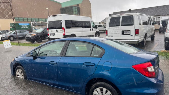
CHARLESTON, S.C. – Roads in Charleston, South Carolina, were impassable due to flooding on Sunday after torrential rain drenched cities across the Southeast and mid-Atlantic as deep tropical moisture flows in from the Gulf.
After steady rain and storms on Saturday, more potentially record-breaking precipitation is expected Sunday and Monday.

Rain soaking Panama City Beach, Florida
It's been a wet morning in Panama City. FOX Weather's Brandy Campbell captured video of residents running through the rain and triathletes bicycling through the downpours.
According to the National Weather Service, Charleston International Airport in South Carolina has received 1.99 inches of rain since midnight. This breaks the rainfall record for May 11 of 1.93 inches, set in 1952.
In addition, downtown Charleston has received 2.06 inches of rain since midnight. That crushes the previous record rainfall for May 11 of 1.57 inches, set 126 years ago in 1899.
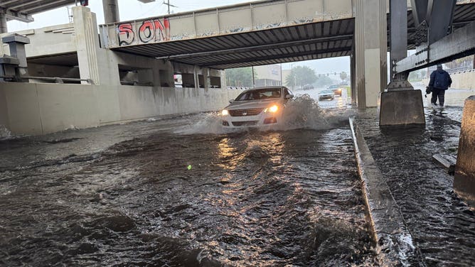
![New Orleans Flooding]() Image 1 of 4
Image 1 of 4Flooding in New Orleans on May 9, 2025. (Chris Welty/WVUE FOX 8)
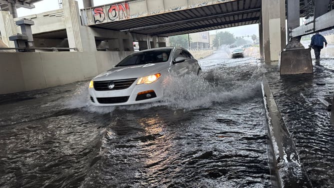
![New Orleans Flooding]() Image 2 of 4
Image 2 of 4Flooding in New Orleans on May 9, 2025. (Chris Welty/WVUE FOX 8)
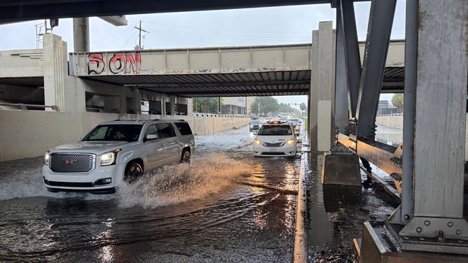
![New Orleans Flooding]() Image 3 of 4
Image 3 of 4Flooding in New Orleans on May 9, 2025. (Chris Welty/WVUE FOX 8)
![New Orleans Flooding]() Image 4 of 4
Image 4 of 4Flooding in New Orleans on May 9, 2025. (Chris Welty/WVUE FOX 8)
In Florida, Northwest Florida Beaches International Airport in Panama City picked up a whopping 0.75 inches of rain in just eight minutes between 3:56 a.m. and 4:04 a.m. CT, which is a staggering rainfall rate of 5.63 inches an hour.
Panama City's two-hour rainfall total between 3 a.m. and 5 a.m. CT was 2.26 inches.
DOWNLOAD THE FREE FOX WEATHER APP

It was a dark and gloomy Mother's Day in Florida as heavy rain drenched the area.
Heavy rain accompanied by thunder and lightning dampened the big day for those in the South.
The slow-moving storm system lingering along the Gulf Coast is expected to continue sending waves of rain and thunderstorms across parts of Florida, Georgia and the Carolinas on Mother’s Day and into the start of the new workweek.
Some communities could see over 4 inches of rain, especially where thunderstorms linger over a region. The ground in many areas will already be saturated from earlier rain, so it won’t take much to trigger flash flooding.
On Sunday morning, numerous Flash Flood Warnings were issued in parts of Alabama, Florida and South Carolina due to the relentless rounds of heavy rain. Those have since expired.

(FOX Weather)
NOAA's Weather Prediction Center is concerned about additional flooding and has placed millions of people in the Southeast and mid-Atlantic in a Level 2 out of 4 flood threat on Sunday and Monday.
Florida, southern Georgia and southern South Carolina are in the bull's-eye for the heaviest rain on Sunday, but parts of Alabama, Mississippi and even western North Carolina could also see localized flooding.

(FOX Weather)
Western North Carolina is still in recovery mode after communities there were decimated by Hurricane Helene's onslaught last year, although rainfall totals in that region aren't expected to be anywhere near what was experienced during that deadly and historic event.
The storm system is expected to slowly drift into the Tennessee Valley by Monday, spreading rain into the Carolinas and Virginia.
Flood Watches are expected to expand as the situation continues to unfold early this week, so residents are urged to prepare.
The system is expected to exit the region by Tuesday, and rainfall totals are expected to remain in the 3-5 inch range for most areas. However, isolated totals of up to 7 inches could fall in some parts of western North Carolina and Virginia.