Deadly winter storm leads to hundreds of crashes across Upper Midwest as snow blankets region
Minnesota State Police report there have been 250 crashes in the state with at least one fatality.
Winter makes comeback across Great Lakes on Friday
Snow falling across the Great Lakes as a system moves through the region. Most will see 1-3 inches Friday, but the FOX Forecast Center is still watching for a swath of heavier snow to take shape later in the day.
MINNEAPOLIS – The northern U.S. experienced a return of winter as a fast-moving storm raced across the Great Lakes, leaving a blanket of snow in its wake and hundreds of crashes on Minnesota highways.
Minnesota State Police report there have been over 250 crashes over a 21-hour period from Thursday evening into Friday afternoon, including 29 crashes that involved injuries and one that involved a fatality.
A 54-year-old man was killed in a crash on an icy Interstate 90 in Manchester Township Thursday evening, the MSP reported. No other details about the crash were given.
In addition, another 142 vehicles had spun out and three semi-trucks had jackknifed, MSP reported.
![The beginning of spring has brought with it a snowy theme in Madison, Wisconsin, on Friday. The snowy weather has caused a difficult morning commute and travel complications for students trying to fly out for spring break.]() Image 1 of 12
Image 1 of 12The beginning of spring has brought with it a snowy theme in Madison, Wisconsin, on Friday. The snowy weather has caused a difficult morning commute and travel complications for students trying to fly out for spring break. (Robert Ray)
![The beginning of spring has brought with it a snowy theme in Madison, Wisconsin, on Friday. The snowy weather has caused a difficult morning commute and travel complications for students trying to fly out for spring break.]() Image 2 of 12
Image 2 of 12The beginning of spring has brought with it a snowy theme in Madison, Wisconsin, on Friday. The snowy weather has caused a difficult morning commute and travel complications for students trying to fly out for spring break. (Robert Ray)
![The beginning of spring has brought with it a snowy theme in Madison, Wisconsin, on Friday. The snowy weather has caused a difficult morning commute and travel complications for students trying to fly out for spring break.]() Image 3 of 12
Image 3 of 12The beginning of spring has brought with it a snowy theme in Madison, Wisconsin, on Friday. The snowy weather has caused a difficult morning commute and travel complications for students trying to fly out for spring break. (Robert Ray)
![The beginning of spring has brought with it a snowy theme in Madison, Wisconsin, on Friday. The snowy weather has caused a difficult morning commute and travel complications for students trying to fly out for spring break.]() Image 4 of 12
Image 4 of 12The beginning of spring has brought with it a snowy theme in Madison, Wisconsin, on Friday. The snowy weather has caused a difficult morning commute and travel complications for students trying to fly out for spring break. (Robert Ray)
![The beginning of spring has brought with it a snowy theme in Madison, Wisconsin, on Friday. The snowy weather has caused a difficult morning commute and travel complications for students trying to fly out for spring break.]() Image 5 of 12
Image 5 of 12The beginning of spring has brought with it a snowy theme in Madison, Wisconsin, on Friday. The snowy weather has caused a difficult morning commute and travel complications for students trying to fly out for spring break. (Robert Ray)
![The beginning of spring has brought with it a snowy theme in Madison, Wisconsin, on Friday. The snowy weather has caused a difficult morning commute and travel complications for students trying to fly out for spring break.]() Image 6 of 12
Image 6 of 12The beginning of spring has brought with it a snowy theme in Madison, Wisconsin, on Friday. The snowy weather has caused a difficult morning commute and travel complications for students trying to fly out for spring break. (Robert Ray)
![The beginning of spring has brought with it a snowy theme in Madison, Wisconsin, on Friday. The snowy weather has caused a difficult morning commute and travel complications for students trying to fly out for spring break.]() Image 7 of 12
Image 7 of 12The beginning of spring has brought with it a snowy theme in Madison, Wisconsin, on Friday. The snowy weather has caused a difficult morning commute and travel complications for students trying to fly out for spring break. (Robert Ray)
![The beginning of spring has brought with it a snowy theme in Madison, Wisconsin, on Friday. The snowy weather has caused a difficult morning commute and travel complications for students trying to fly out for spring break.]() Image 8 of 12
Image 8 of 12The beginning of spring has brought with it a snowy theme in Madison, Wisconsin, on Friday. The snowy weather has caused a difficult morning commute and travel complications for students trying to fly out for spring break. (Robert Ray)
![The beginning of spring has brought with it a snowy theme in Madison, Wisconsin, on Friday. The snowy weather has caused a difficult morning commute and travel complications for students trying to fly out for spring break.]() Image 9 of 12
Image 9 of 12The beginning of spring has brought with it a snowy theme in Madison, Wisconsin, on Friday. The snowy weather has caused a difficult morning commute and travel complications for students trying to fly out for spring break. (Robert Ray)
![The beginning of spring has brought with it a snowy theme in Madison, Wisconsin, on Friday. The snowy weather has caused a difficult morning commute and travel complications for students trying to fly out for spring break.]() Image 10 of 12
Image 10 of 12The beginning of spring has brought with it a snowy theme in Madison, Wisconsin, on Friday. The snowy weather has caused a difficult morning commute and travel complications for students trying to fly out for spring break. (Robert Ray)
![The beginning of spring has brought with it a snowy theme in Madison, Wisconsin, on Friday. The snowy weather has caused a difficult morning commute and travel complications for students trying to fly out for spring break.]() Image 11 of 12
Image 11 of 12The beginning of spring has brought with it a snowy theme in Madison, Wisconsin, on Friday. The snowy weather has caused a difficult morning commute and travel complications for students trying to fly out for spring break. (Robert Ray)
![The beginning of spring has brought with it a snowy theme in Madison, Wisconsin, on Friday. The snowy weather has caused a difficult morning commute and travel complications for students trying to fly out for spring break.]() Image 12 of 12
Image 12 of 12The beginning of spring has brought with it a snowy theme in Madison, Wisconsin, on Friday. The snowy weather has caused a difficult morning commute and travel complications for students trying to fly out for spring break. (Robert Ray)


Snow totals varied widely across Wisconsin, ranging from generally 2-6 inches on Friday morning, leading to slippery, snow-covered highways.
Communities in Northern Illinois around Rockford saw the most snow, with some observation sites reporting more than 9".
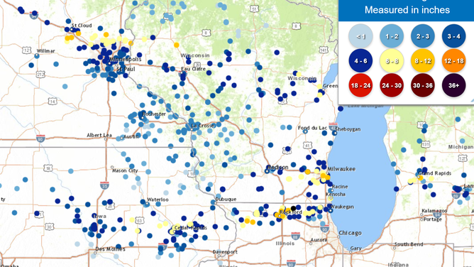
Snowfall totals as of Friday evening
(FOX Weather)
THUNDERSNOW: WHAT CAUSES LIGHTNING AND THUNDER DURING A SNOWSTORM?
"The system is so strong in the mid-levels of the atmosphere that we're getting thundersnow reported across the area," FOX Weather Winter Storm Specialist Tom Niziol said. "The Storm Prediction Center just put out a discussion referring to the fact that we've got a lot of deep convection going on with that thundersnow. That's why you're going to see these snowfall rates."
Winter Weather Advisories stretched from Minnesota through Wisconsin into Michigan for Friday's snow, including Minneapolis, Minnesota; Mason City in Iowa; and Milwaukee and Green Bay in Wisconsin.
The FOX Forecast Center said the ground has been bare leading up to this active stretch, but any fresh snow received Friday will make it easier for snow to accumulate for the next event - an even stronger winter storm forecast for the region early next week.
Storm to bring heavy snows to inland Northeast
The storm will then move into the Northeast Friday night into Saturday, and it’s going to be a mess.
Winter Storm Warnings are already in effect across portions of the interior Northeast and northern New England in advance of heavy snow from a combination of two systems – this one moving across the northern tier and a second system moving up the East Coast that will also bring heavy rain to southern New England and along the Interstate 95 corridor.
WINTER STORM WARNINGS ISSUED AS COASTAL STORM EYES NORTHEAST WITH SNOW, FLOODING RAIN FOR SATURDAY
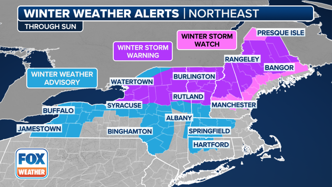
This graphic shows Winter Storm Watches in effect in the Northeast
(FOX Weather)
The FOX Forecast Center said the snow will overspread the region from west to east and quickly accumulate starting Friday night. Areas of heavy snow will continue on Saturday before winding down Saturday night.