Major spring snowstorm could dump over foot of snow from Dakotas to Wisconsin
Snowfall rates for the storm will likely be high, resulting in heavy snow potential. Broad coverage of 8-12 inches of snow is increasing, which has prompted widespread winter weather alerts across the region. Blizzard conditions will also be possible along the shore of Lake Superior in the Arrowhead of Minnesota.
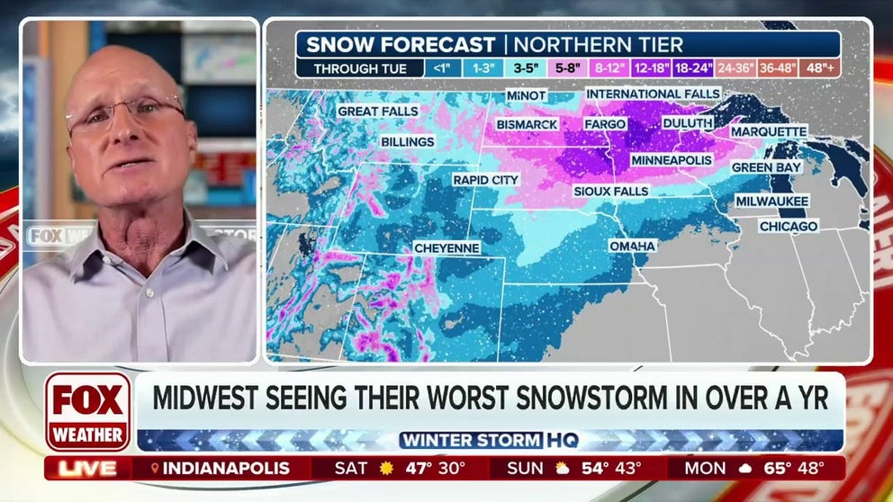
Midwest seeing their worst snowstorm in over a year
A major spring storm is brewing this weekend and is becoming almost certain the Upper Midwest will get their worst snowstorm in over a year.
A major spring storm is brewing this weekend, and it is becoming almost certain the Upper Midwest will get its worst snowstorm in over a year. A wide area of the region is looking at the potential for at least 8-12 inches of snow, with snowfall totals nearing two feet possible in parts of Minnesota and the eastern Dakotas.
The big event will primarily start on Sunday. Although some snow was already falling on Saturday across Montana, the main focus on Sunday will be the Upper Midwest.

(FOX Weather)
Winter Storm Watches and Warnings stretch from Montana through the Dakotas and into Minnesota and Wisconsin.
"All these areas that are sitting under Winter Storm Watches, I would not be surprised if some of that changes over to Blizzard Warnings," FOX Weather Winter Storm Specialist Tom Niziol said. "The wind speeds associated with this are going to be very strong back across parts of the northern Plains, 40-50 mph and coming off of Lake Superior, where the Blizzard Warnings are already in effect. They're no stranger to this ... what I refer to as 'Blizzard Alley.'"
HERE'S WHY 'BLIZZARD ALLEY' IS IN THE NORTHERN PLAINS

(FOX Weather)
While the storm's origins began in the Pacific Northwest, a new area of low pressure will develop east of the Rockies, fueled by a big dip in the jet stream across the Rockies. Within this dip in the jet stream, arctic air will spill south of the border, flooding the central part of the country.
To the south, moisture will be drawn north as southerly winds increase. A big-time snowstorm is expected with the cold air and abundant moisture in supply.
"Because it is such a deep system, it’s going to be able to tap into a lot of Gulf moisture that will wrap back around the cold air in this system and put heavy, wet snow down across probably eastern South Dakota and western Minnesota to see the heaviest," FOX Weather Winter Storm Specialist Tom Niziol said.

(FOX Weather)
This will be a long-duration event with multiple waves of precipitation potentially lasting through Tuesday or Wednesday of next week, the FOX Forecast Center said.
The most significant snow accumulations are likely from Sunday through Monday as the low pressure strengthens. Snowfall rates for the storm will likely be high, resulting in heavy snow potential.
WHEN CAN YOU EXPECT THE LAST SNOW OF THE SEASON?

(FOX Weather)
The storm may produce over a foot of snow near the Twin Cities – the most snow since January last year. This could also be the worst spring snowstorm for the region since 2018.
Farther to the south across the Plains, a blizzard may break out. Here, strong winds gusting over 40-50 mph will create blowing and drifting snow with widespread travel impacts expected. Blizzard conditions will also be possible along the shore of Lake Superior in the Arrowhead of Minnesota, where Blizzard Warnings are already in effect.

(FOX Weather)
Cold air will overtake the middle part of the country through Wednesday and will even make it into the Southern Plains, the FOX Forecast Center said.
Temperatures will plummet to 20-30 degrees below average as daytime highs stay below freezing in the Upper Midwest to start next week. Besides being cold, its also notable that this stretch of colder air will make the snow cover last.
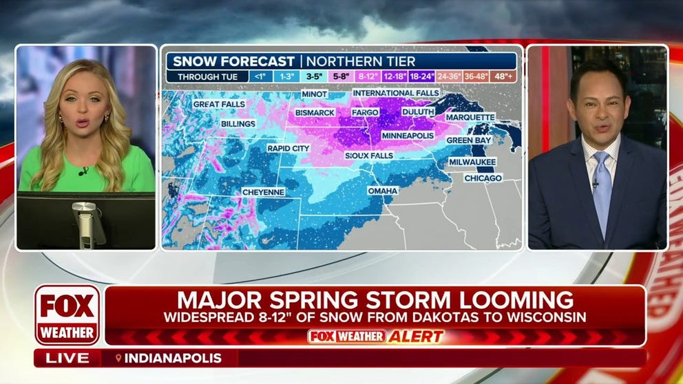
Widespread 8-12 inches of snow possible from Dakotas to Wisconsin as major spring storm looms
A major spring storm is brewing this weekend, and it is becoming almost certain the Upper Midwest will get its worst snowstorm in over a year.
Meanwhile, on the southern side of the storm, the FOX Forecast Center is tracking the threat of a multiday severe weather risk that could produce hail, damaging winds and tornadoes as it sweeps from west to east.
MULTIDAY SEVERE WEATHER RISK RAMPS UP ON SUNDAY ACROSS PLAINS
The first round of thunderstorm activity is expected to fire over the Plains on Sunday, with communities further east in the threat zones on Monday and Tuesday.