

Over 230M people to face brutal heat dome, life-threatening temperatures ahead of America's 250th birthday
Temperatures in the 90s are spreading across the Midwest and will reach the East Coast by midweek, when it will feel like 100 to 110 degrees for tens of millions of people ahead of America's 250th birthday.
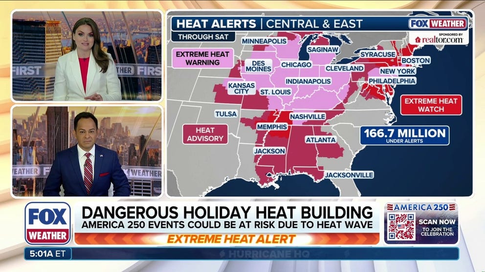
Extreme temperatures building across central, eastern US as heat dome bakes millions ahead of July 4
A massive, life-threatening heat dome is settling over parts of the Central U.S. before spreading eastward Wednesday. More than 230 million people will see temperatures above 90 degrees, while more than 41 million will experience triple-digit heat at some point from midweek through the holiday weekend. Air temperatures are expected to peak across parts of the Midwest, including St. Louis, Chicago, and Detroit, by Wednesday. Meanwhile, parts of the Mid-Atlantic and Northeast will likely see 100-degree temperatures by Thursday, with nighttime lows remaining in the 80s.
Temperatures in the 90s are spreading across the Midwest and will reach the East Coast by Wednesday, when it will feel like 100 to 110 degrees for tens of millions of people as a life-threatening heat dome expands eastward ahead of America's 250th birthday.
WHAT IS A HEAT DOME AND HOW CAN IT AFFECT YOU DURING THE SUMMER MONTHS?
More than 230 million people will see air temperatures surpass 90 degrees through the week, with more than 20 states forecast to surpass triple-digits in the days leading up to July 4, the FOX Forecast Center said.
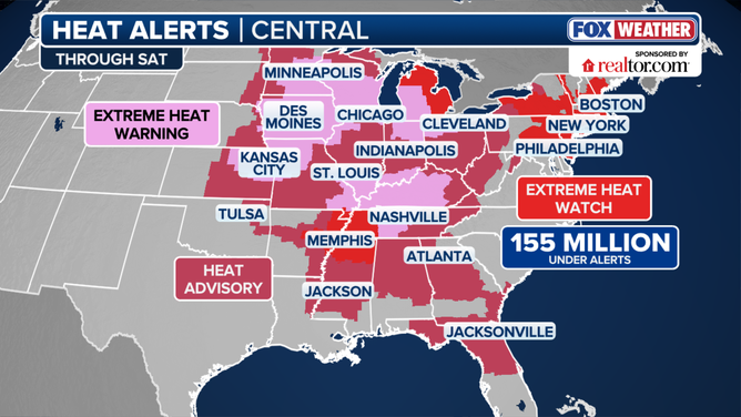
Heat Alerts
(FOX Weather / FOX Weather)
Within a heat dome, a strong high pressure system acts like a lid, trapping hot air near the ground and preventing cooler air from mixing in, allowing heat to build day after day.
HOW HIGH PRESSURE AND LOW PRESSURE DRIVE THE WEATHER
This is the first major heat wave of the summer for both the central and eastern U.S. Heat is intensifying across the Midwest, where temperatures are expected to reach the mid to upper 90s.
While air temperatures are expected to peak by Wednesday across parts of the region, including St. Louis, Chicago, and Detroit, feel-like temperatures above 100 degrees could linger through midweek.
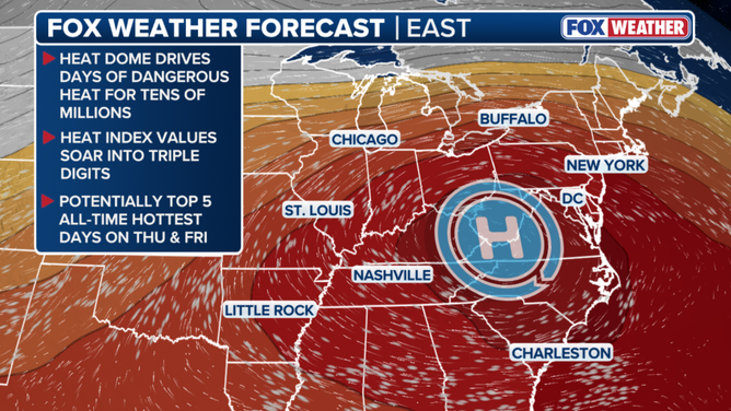
This graphic shows the extreme heat across portions of the country this week.
"With dew points rising into the mid to lower 70s, heat index values will approach 105 degrees or higher," the FOX Forecast Center said. "As a result, an extreme heat risk is likely across the Midwest, Ohio Valley and Tennessee Valley through Wednesday and Thursday."
EXTREME HEAT SAFETY: RECOGNIZING SIGNS OF HEAT ILLNESS AND HOW TO TREAT IT
Parts of the central U.S. are already under an Extreme HeatRisk, the highest category on NOAA and the CDC's extreme heat scale, indicating a long-duration heat wave with little or no overnight relief that can affect anyone without access to cooling and adequate hydration.
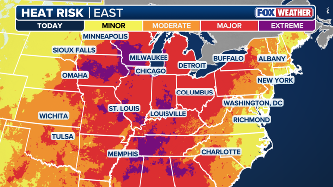
Extreme heat risk.
As people flock outdoors to hang by the pool, at the beach, for barbecues and more, it is important to prepare for the conditions by wearing sun protection and drinking plenty of hydrating fluids.
Extreme heat reaches East Coast midweek
By Thursday, the core of the extreme heat will be anchored over the East Coast, where many of the country's most densely populated cities will experience days of potentially record-breaking temperatures and dangerously high heat index values.
EXTREME HEAT SAFETY: HOW TO PREPARE AND STAY COOL DURING A HEAT WAVE
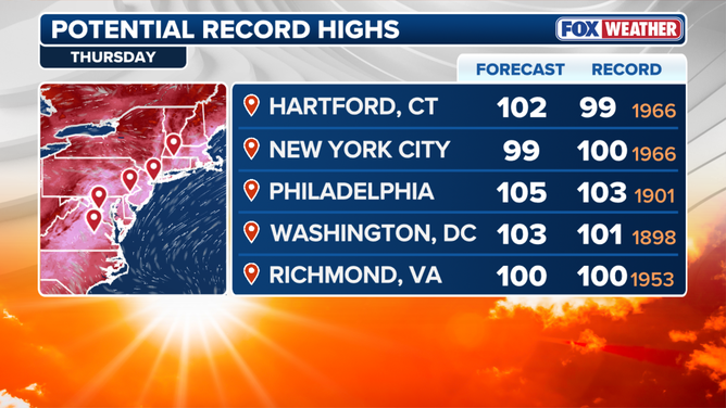
Potential record-high temperatures Thursday.
(FOX Weather / FOX Weather)
Washington D.C., Baltimore, Philadelphia, and New York City will see multiple days exceeding 100 degrees.
"When you add in the moisture in the air, it will feel like a stifling 110 to 115 during the hottest parts of the day," the FOX Forecast Center said.
AMERICA 250: SEND US YOUR PHOTOS AND VIDEOS FROM ACROSS THE COUNTRY
The last time either New York or Philadelphia had back-to-back triple-digit days was in 2011.
Raleigh, North Carolina, could see its warmest day on record, with a potential high of 106 degrees late this week.
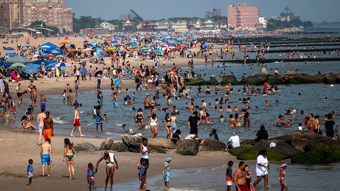
FILE - NEW YORK, NEW YORK - JULY 30: People try to stay cool at the beach at Coney Island in Brooklyn as the region experiences another heatwave on July 30, 2025 in New York City.
((Photo by Spencer Platt/Getty Images) / Getty Images)
Temperatures are expected to ease slightly across both the Mid-Atlantic and Northeast on July 4 itself.
FOX Weather Meteorologist Britta Merwin advised people visiting the nation's capital to take advantage of air-conditioned spaces, like museums.
Heat safety experts also advise wearing loose, lightweight, light-colored clothing. Light clothing doesn’t absorb sunlight as easily as dark colors do.
Lightweight, breathable materials like linen, cotton and muslin are all great for hot temperatures.
Download the free FOX Weather app to stay up-to-date with the latest conditions and alerts to stay safe for the July 4th weekend.