Great Lakes region faces feet of lake-effect snow as Midwest winter storm winds down
The powerful storm has left thousands of people across the Great Lakes without power which could become problematic as temperatures plunge behind the storm with an arctic blast set to overtake the Midwest.
Gusty winds could lead to whiteout conditions along Great Lakes
Winter weather is not over yet, and multiple states are preparing for lake-effect conditions. As this snow moves eastward across the Great Lakes, we could experience whiteout conditions. FOX 2 Detroit Meteorologist Lori Pinson joins FOX Weather to discuss the situation.
CHICAGO – A powerful winter storm that impacted the Midwest with blizzard conditions and widespread power outages is in its final stages, but winds off the Great Lakes are poised to become problematic with heavy lake-effect snow.
The FOX Forecast Center warned that significant lake-effect snow bands were possible for Indiana, Michigan, Pennsylvania and parts of New York through the Martin Luther King Jr. holiday.
The warm water temperatures of the Great Lakes and blustery conditions have led to a favorable setup for heavy snow, and impacts are already being felt.
The National Weather Service issued a Snow Squall Warning for parts of Monroe County, Michigan, on Saturday afternoon and cautioned that rapidly falling visibility and gusty winds would make travel treacherous.

(FOX Weather)
Farther east in New York, a travel ban was slated to go into effect for Erie County at 9 p.m., and authorities said they'll discuss its status on Sunday.
Gov. Kathey Hochul said the state was expecting to see its worst conditions since the catastrophic blizzard of 2022.
Sunday's NFL game featuring the Pittsburgh Steelers and Buffalo Bills was postponed until at least Monday due to the threat of life-threatening weather conditions.
PITTSBURGH STEELERS, BUFFALO BILLS GAME POSTPONED TO MONDAY DUE TO HEAVY SNOW THREAT
Thousands of power outages
More than 500,000 electric outages were reported across the country Saturday afternoon by PowerOutages.us, with the greatest concentrations centered in southeastern Wisconsin and eastern Michigan.
(FOX Weather)
FOX 2 in Detroit reported more than 160,000 DTE Energy and Consumers Energy customers were without power Saturday morning. DTE Electric, Michigan's largest utility provider, said it had nearly 1,100 linemen on standby and ready to respond to outages.
"Our crews have been at work since the weather began and are making repairs as quickly and safely as possible," DTE told FOX 2. "Crews from across the country arrived last night to support our DTE crews and speed restoration for customers."
The company did not publicly state how long it would take to restore everyone's electricity, but many will be wishing for a quick response as temperatures are not expected to reach above 20 degrees through most of the upcoming week.
Heavy snow and strong winds were simply too much for some trees and power lines in Waterford, Wisconsin, on Friday, as video showed them on fire amid surrounding snowy conditions.
HERE'S WHY 'BLIZZARD ALLEY' IS IN THE NORTHERN PLAINS
Over 5,000 flights delayed or canceled
For many impacted by the storm system, the snowfall was the largest accumulation this season and was detrimental to travelers on roadways and at airports.
Chicago's airports had the most cancellations and delays among the more than two dozen cities impacted by the winter weather.
Road salt helping fight frozen Chicago streets
A winter storm system that affected the Midwest is now moving towards the east, but its impact still remains. Around 150 million Americans are expected to be impacted by wind alerts, and life-threatening conditions are still a concern. FOX Weather's Robert Ray has been reporting on this storm in Chicago.
O'Hare International Airport (ORD) reported more than 800 flights were canceled as of Friday afternoon due to the winter storm, as the FAA placed a ground stop at the airport. About 70 cancellations were reported Saturday morning, according to Flightaware.com.
Chicago's Midway Airport reported nearly 300 cancellations as of early Friday afternoon, according to Flightaware.com. The site showed about a half-dozen canceled flights Saturday morning.
![It was a snowy morning in Grand Rapids, Michigan, on Saturday. Lake-effect snow will continue to be a problem throughout the afternoon. Winter Storm Warnings have been issued across most of the state.]() Image 1 of 25
Image 1 of 25It was a snowy morning in Grand Rapids, Michigan, on Saturday. Lake-effect snow will continue to be a problem throughout the afternoon. Winter Storm Warnings have been issued across most of the state. (Max Gorden)
![It was a snowy morning in Grand Rapids, Michigan, on Saturday. Lake-effect snow will continue to be a problem throughout the afternoon. Winter Storm Warnings have been issued across most of the state.]() Image 2 of 25
Image 2 of 25It was a snowy morning in Grand Rapids, Michigan, on Saturday. Lake-effect snow will continue to be a problem throughout the afternoon. Winter Storm Warnings have been issued across most of the state. (Max Gorden)
![It was a snowy morning in Grand Rapids, Michigan, on Saturday. Lake-effect snow will continue to be a problem throughout the afternoon. Winter Storm Warnings have been issued across most of the state.]() Image 3 of 25
Image 3 of 25It was a snowy morning in Grand Rapids, Michigan, on Saturday. Lake-effect snow will continue to be a problem throughout the afternoon. Winter Storm Warnings have been issued across most of the state. (Max Gorden)
![It was a snowy morning in Grand Rapids, Michigan, on Saturday. Lake-effect snow will continue to be a problem throughout the afternoon. Winter Storm Warnings have been issued across most of the state.]() Image 4 of 25
Image 4 of 25It was a snowy morning in Grand Rapids, Michigan, on Saturday. Lake-effect snow will continue to be a problem throughout the afternoon. Winter Storm Warnings have been issued across most of the state. (Max Gorden)
![A winter storm system that affected the Midwest is now moving towards the east, but its impact still remains. Snow covered downtown Chicago on Saturday morning.]() Image 5 of 25
Image 5 of 25A winter storm system that affected the Midwest is now moving towards the east, but its impact still remains. Snow covered downtown Chicago on Saturday morning. (Robert Ray)
![A winter storm system that affected the Midwest is now moving towards the east, but its impact still remains. Snow covered downtown Chicago on Saturday morning.]() Image 6 of 25
Image 6 of 25A winter storm system that affected the Midwest is now moving towards the east, but its impact still remains. Snow covered downtown Chicago on Saturday morning. (Robert Ray)
![A winter storm system that affected the Midwest is now moving towards the east, but its impact still remains. Snow covered downtown Chicago on Saturday morning.]() Image 7 of 25
Image 7 of 25A winter storm system that affected the Midwest is now moving towards the east, but its impact still remains. Snow covered downtown Chicago on Saturday morning. (Robert Ray)
![With three days until the Iowa Caucus, Iowans plow and shovel streets to stay ahead of the falling snow as a blizzard hits Iowa accompanied by high winds and freezing cold temperatures in Fort Dodge, Iowa on Friday, January 12, 2024.]() Image 8 of 25
Image 8 of 25With three days until the Iowa Caucus, Iowans plow and shovel streets to stay ahead of the falling snow as a blizzard hits Iowa accompanied by high winds and freezing cold temperatures in Fort Dodge, Iowa on Friday, January 12, 2024. (Melina Mara/The Washington Post)
![A pedestrian walks through snow during a winter storm ahead of the Iowa caucus in Des Moines, Iowa, US, on Friday, Jan. 12, 2024.]() Image 9 of 25
Image 9 of 25A pedestrian walks through snow during a winter storm ahead of the Iowa caucus in Des Moines, Iowa, US, on Friday, Jan. 12, 2024. (Al Drago/Bloomberg)
![Icicles on a house during a winter storm ahead of the Iowa caucus in West Des Moines, Iowa, US, on Friday, Jan. 12, 2024.]() Image 10 of 25
Image 10 of 25Icicles on a house during a winter storm ahead of the Iowa caucus in West Des Moines, Iowa, US, on Friday, Jan. 12, 2024. (Al Drago/Bloomberg)
![Shoppers exit a grocery store during a winter storm ahead of the Iowa caucus in Des Moines, Iowa, US, on Friday, Jan. 12, 2024.]() Image 11 of 25
Image 11 of 25Shoppers exit a grocery store during a winter storm ahead of the Iowa caucus in Des Moines, Iowa, US, on Friday, Jan. 12, 2024. (Al Drago/Bloomberg)
![A resident shovels snow during a winter storm ahead of the Iowa caucus in Des Moines, Iowa, US, on Friday, Jan. 12, 2024.]() Image 12 of 25
Image 12 of 25A resident shovels snow during a winter storm ahead of the Iowa caucus in Des Moines, Iowa, US, on Friday, Jan. 12, 2024. (Al Drago/Bloomberg)
![]() Image 13 of 25
Image 13 of 25Rebecca Zimmerman moves along Harlem Avenue on her way to work in Oak Park from Forest Park as a winter storm hits the Chicago area with heavy snow and near-blizzard conditions, Jan. 12, 2024. (Antonio Perez/Chicago Tribune/Tribune News Service)
![A car is buried by blowing snow along the Interstate 235 John MacVicar Freeway as winter storm Gerri dumps inches of snow with high winds on January 12, 2024 in Des Moines, Iowa.]() Image 14 of 25
Image 14 of 25A car is buried by blowing snow along the Interstate 235 John MacVicar Freeway as winter storm Gerri dumps inches of snow with high winds on January 12, 2024 in Des Moines, Iowa. (Chip Somodevilla)
![Plow trucks work to clear the Interstate 235 John MacVicar Freeway Freeway as winter storm Gerri dumps inches of snow with high winds on January 12, 2024 in Des Moines, Iowa.]() Image 15 of 25
Image 15 of 25Plow trucks work to clear the Interstate 235 John MacVicar Freeway Freeway as winter storm Gerri dumps inches of snow with high winds on January 12, 2024 in Des Moines, Iowa. (Chip Somodevilla)
![A person walks down 4th street as heavy snow continues to fall on January 12, 2024 in Sioux City, Iowa.]() Image 16 of 25
Image 16 of 25A person walks down 4th street as heavy snow continues to fall on January 12, 2024 in Sioux City, Iowa. (Kevin Dietsch)
![A front loader drives down a street as heavy snow continues to fall on January 12, 2024 in Sioux City, Iowa.]() Image 17 of 25
Image 17 of 25A front loader drives down a street as heavy snow continues to fall on January 12, 2024 in Sioux City, Iowa. (Kevin Dietsch)
![]() Image 18 of 25
Image 18 of 25Plow trucks work to clear the Interstate 235 John MacVicar Freeway Freeway as winter storm Gerri dumps inches of snow with high winds on January 12, 2024 in Des Moines, Iowa. (Chip Somodevilla)
![Tire tracks are seen on a snow-covered road in Chicago, Illinois, on Jan. 12, 2024.]() Image 19 of 25
Image 19 of 25Tire tracks are seen on a snow-covered road in Chicago, Illinois, on Jan. 12, 2024. (Robert Ray)
![A truck works to plow streets in Chicago, Illinois, during a winter storm Jan. 12, 2024.]() Image 20 of 25
Image 20 of 25A truck works to plow streets in Chicago, Illinois, during a winter storm Jan. 12, 2024. (Robert Ray)
![Snow covers the ground outside the Adler Planetarium in Chicago, Illinois, during a winter storm Jan. 12, 2024.]() Image 21 of 25
Image 21 of 25Snow covers the ground outside the Adler Planetarium in Chicago, Illinois, during a winter storm Jan. 12, 2024. (Robert Ray)
![Snow flies early Jan. 12, 2024, in Chicago, Illinois.]() Image 22 of 25
Image 22 of 25Snow flies early Jan. 12, 2024, in Chicago, Illinois. (Robert Ray)
![An angry Lake Michigan pounds against the shore in Chicago, Illinois, during a winter storm Jan. 12, 2024.]() Image 23 of 25
Image 23 of 25An angry Lake Michigan pounds against the shore in Chicago, Illinois, during a winter storm Jan. 12, 2024. (Robert Ray)
![Snow falls in Chicago, Illinois, on Jan. 12, 2024.]() Image 24 of 25
Image 24 of 25Snow falls in Chicago, Illinois, on Jan. 12, 2024. (Robert Ray)
![Snow obscures the view along Lake Michigan in Chicago, Illinois, during a winter storm Jan. 12, 2024.]() Image 25 of 25
Image 25 of 25Snow obscures the view along Lake Michigan in Chicago, Illinois, during a winter storm Jan. 12, 2024. (Robert Ray)


FOX Weather Meteorologist Amy Freeze, was reporting live from Chicago and heard thunder during some of the snow falling over the Windy City on Friday morning.
Iowa State Patrol Trooper Paul Gardner captured footage of the hazardous conditions on U.S. Route 20 in Calhoun County and urged people to stay home and be safe.
The state's transportation department was advising people not to travel on most roads east of Des Moines. The Illinois DOT was also reporting that most roads across the northern part of the state were dangerous because of blowing snow. The bulk of roads in Wisconsin were either listed by the state's DOT as slippery in stretches or snow-covered.
Marshalltown, Iowa, located about an hour northeast of Des Moines, was the first location to verify blizzard conditions in the state on Friday. Drifting snow piles combined with the wind created dangerous driving conditions.
Snowfall totals top a foot
The greatest snowfall totals topped over a foot in several states across the Midwest, and outside of major lake-effect snow bands, Wisconsin appeared to take top honors.
The Wisconsin communities of West Bend and Suamico reported seeing 18" of new snowfall by Saturday afternoon.
Another concentration of heavy snow totals appeared to be the Quad Cities, along the Iowa-Illinois border.
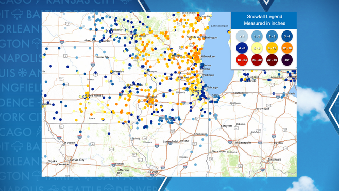
Storm snowfall total amounts
At last report, Davenport saw just over 15 inches of snow, with many readings above a foot in eastern Iowa.
Major cities along the Great Lakes appeared to have missed seeing substantial accumulations.
Observation sites around downtown Chicago only reported about 2 inches of precipitation, while Milwaukee saw around 5 inches of new powder.
Temperatures plunge after the storm
As if the snow won’t make conditions dangerous enough, millions of Americans are bracing for a bitter blast of frigid air that moves in from Canada.
"And this is the storm that really unlocks the arctic cold that comes in behind it," FOX Weather Meteorologist Jane Minar said. "So, get ready for this flash freeze that’s going to happen in the weekend."
The combination of the winds and cold weather is expected to make the temperatures feel as cold as 50 degrees below zero in some spots throughout the Plains. The life-threatening wind chills could result in frostbite in just minutes, and local National Weather Service offices warned everyone who faced the potential of dangerous conditions to stay indoors.
"If you must be outside, make sure you wear appropriate clothing in layers. Ensure portable heaters are used correctly and that you have a carbon monoxide detector. Do not use generators or grills inside. If traveling, carry a winter survival kit and inform others of your travel plans," the NWS office in Bismark, North Dakota, said.
HERE'S HOW LONG IT'LL TAKE YOU TO GET FROSTBITE AS WIND CHILLS DIP BELOW ZERO

(FOX Weather)