Remnants of Mario trigger deadly flash flooding, mudslides as rain surged across Southern California
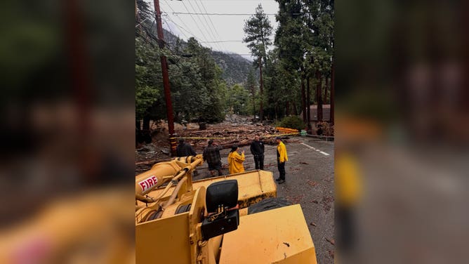
The San Bernardino County Fire Department said Thursday night at least 10 people were stranded on California State Route 38 in the San Bernardino mountains, blocked by debris flows.
Tropical moisture sweeps southern California, leading to mudslides, flooding
The remnants of Tropical Storm Mario have brought rounds of heavy rain to southern California, causing flooding and mudslides to occur. A 2-year-old boy died in the flooding after his family's car was swept away.
BARSTOW, Calif. – A surge of rainfall and powerful thunderstorms moved across Southern California and the Desert Southwest U.S. on Thursday, leaving a toddler dead and causing several mudslides and debris flows.
The moisture was associated with the remnants of Tropical Storm Mario that fell apart over the Eastern Pacific earlier in the week.
Flash flooding claimed the life of a 2-year-old boy in Barstow, when the car he and his father were riding in was swept away Thursday evening. Rescue crews found the father alive, stranded on a makeshift island later that evening, but his son's body wasn't found until Friday afternoon.
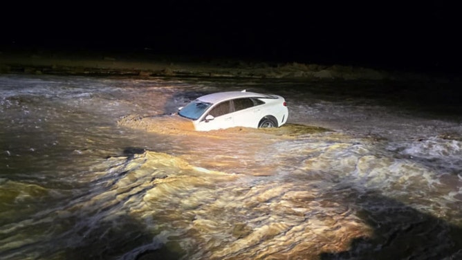
Car swept away in floodwaters in Barstow, California on Sept. 18, 2025.
(Barstow Police Department / FOX Weather)
"Our hearts go out to the family and loved ones during this unimaginably difficult time," Barstow Police said. "We extend our deepest condolences to those affected by this tragedy."
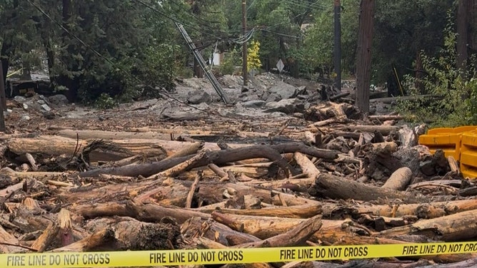
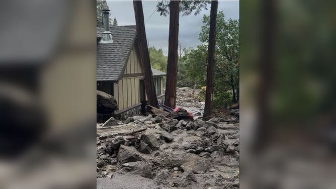
One of the hardest hit towns was over in Oak Glen in San Bernardino County. There, multiple torrents of mud and water raced down from the nearby mountains, flooding the town in a sudden barrage of debris.
A man made a daring decision to try and save her truck as the floodwaters approached town, but was moments too late.
Video shot near the Oak Glen Steakhouse & Saloon shows a man racing to climb into his truck as the muddy river raged just feet away from the parking lot, while shocked onlookers cried warnings of "Watch Out!"
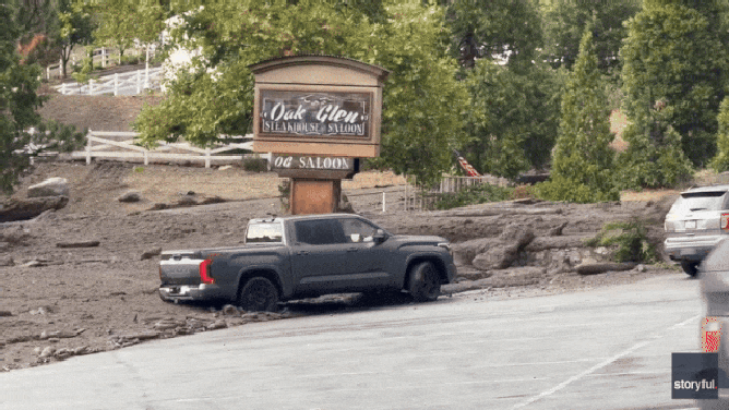
Driver tries to rescue truck from flash flooding in Oak Glen, California on Sept. 18, 2025.
(Gabriel Sedillo via Storyful)
The man jumped into the truck and slammed it into reverse, but moments later, a surge of water and mud overtook the truck and the edge of the parking lot, pulling the truck deeper into the muck. There were no reported injuries.
WATCH: WOMAN TRAPPED IN MUD TRYING TO SAVE TRUCK AS WALL OF WATER SLAMS CALIFORNIA TOWN
The San Bernardino County Fire Department said debris flows had left at least 10 people stranded on California State Route 38 in the San Bernardino mountains. Fire officials said the stranded people were safe and crews worked to clear the roadway.
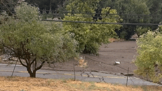
Muddy floodwater swept through Oak Glen, California, on Thursday, September 18, depositing mud and debris and leaving multiple roads closed and vehicles stranded.
(Denisse Romo via Storyful / FOX Weather)
The department said mudslides and debris flows had also impacted roads and homes in parts of Forest Falls, Oak Glen and Potato Canyon.
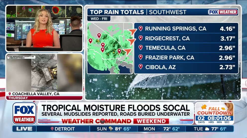
Rainfall totals in the mountains ranged anywhere from a half inch to 2 inches, with a few isolated higher totals. Gauges near Bear Valley in San Bernardino County recorded 2.83 inches while another gauge along Running Springs tallied 4.14 inches.
Farther north, the area around Ridgecrest reported as much as 3.17 inches.
![Mudflow in Forest Falls, California]() Image 1 of 3
Image 1 of 3Mudflow in Forest Falls, California as heavy rains fall from the remnants of Tropical Storm Mario on Sept. 18, 2025. (San Bernardino County Fire Department)
![Mudflow in Forest Falls, California]() Image 2 of 3
Image 2 of 3Mudflow in Forest Falls, California as heavy rains fall from the remnants of Tropical Storm Mario on Sept. 18, 2025. (San Bernardino County Fire Department)
![Mudflow in Forest Falls, California]() Image 3 of 3
Image 3 of 3Mudflow in Forest Falls, California as heavy rains fall from the remnants of Tropical Storm Mario on Sept. 18, 2025. (San Bernardino County Fire Department)
In Kern County, flash flooding covered parts of Highway 14 and trapped a car in mud, the California Highway Patrol reported.
Several roads washed out in Death Valley National Park
Farther east, heavy rains left a muddy mess in Death Valley National Park too, forcing the closure of several roads.
Park officials said Furnace Creek received 0.6 inches of rain Thursday night – about a quarter of the park's annual average of rainfall – in just a few hours.
"The park’s rocky, steep terrain causes water to run off quickly, creating fast-moving flows of mud, rocks and debris," Death Valley NPS officials said. "These floods have covered some roads and have eroded road shoulders, making travel hazardous."

Road covered in mud after remnants from Tropical Storm Mario slam Death Valley National Park.
(Death Valley National Park)
In a sign of how dry the area usually is in September, Needles, California received just 0.33 inches of rain, but it smashed the daily rainfall record for the date.
In addition to the heavy rains, the storms produced quite a bit of lightning. The National Weather Service in San Diego tracked over 9,200 lightning strikes just between Riverside, San Bernardino and San Diego Counties Thursday, with over 400 of those bolts striking the ground.
Tropical Storm Mario packs larger punch as a remnant low
Mario reached peak intensity earlier this week while well off the coast of Mexico, with maximum sustained winds of 65 mph, but the storm quickly weakened after encountering cooler sea-surface temperatures and drier air.
Because of lingering dry air over the Southwest and what has been a tepid monsoon season, meteorologists say rainfall amounts from Mario’s remnants are not expected to be significant enough to provide long-term drought relief.
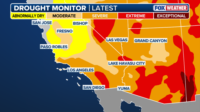
Southwest Drought Monitor.
(FOX Weather)
"This should help out a little bit," FOX Weather Meteorologist Bob Van Dillen said. "I don't think it's going to be enough to bust a drought."
MARIO FIZZLES ALONG MEXICO’S PACIFIC COAST, BUT STILL DRENCHES SHORELINES WITH HEAVY RAINS
Coastal areas dried out Friday, and conditions over the weekend will begin to rebound with sunnier skies and a warming trend.
Highs are expected to climb back into the 80s along the coast, 90s inland and well over 100 degrees in the desert communities, which is more characteristic for September.