Another major winter storm looms for US after weekend nor'easter
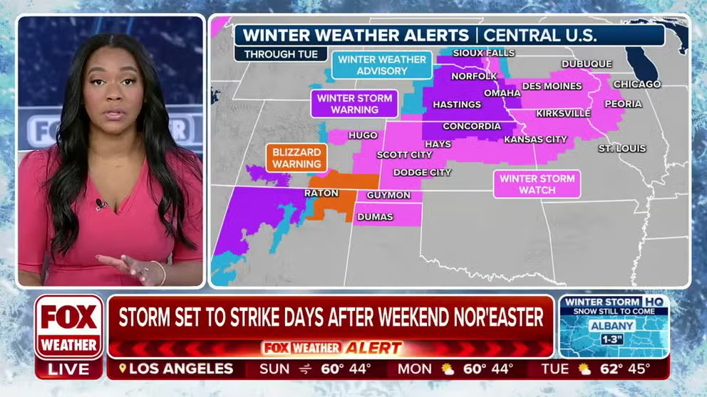
The first winter weather alerts associated with the next major storm have been issued from New Mexico to Iowa.
Massive winter storm threatens US after weekend nor'easter
FOX Weather Meteorologist Kiyana Lewis outlines a powerful winter storm that is set to impact the eastern half of the U.S. on the heels of a weekend nor'easter.
After a nor'easter barrels up the East Coast of the U.S. this weekend, the active weather pattern will bring another powerful storm to the eastern half of the U.S. and create a variety of nasty weather.
According to the FOX Forecast Center, snow, flooding rain, damaging wind and severe weather are all in the forecast as the storm moves from the central U.S. to the Great Lakes.
The storm has already started developing in the Rockies and will rapidly intensify as it moves toward the Plains. By Tuesday and Wednesday, the storm will reach its peak intensity and bring impactful weather from the Southeast to the Northeast.
"We talked about this at the end of 2023," FOX Weather Meteorologist Britta Merwin said. "We had so many discussions here on FOX Weather that we are in for a pattern change. Well, welcome to your pattern change. This is the verification of that forecast."

(FOX Weather)
Snow potential high, amounts uncertain
Snow appears most likely to fall across the central Plains starting late Sunday. The Great Lakes are forecast to see the heaviest snow Tuesday, according to the FOX Forecast Center.
"The timing right now would possibly have some big impacts for places like Chicago, Kansas City, and Detroit as we go into Tuesday of next week," Merwin said. "So this is one to watch."

(FOX Weather)
A Winter Storm Watch has already been issued for parts of more than a half-dozen states, from New Mexico to South Dakota.

(FOX Weather)
The Northeast may also see a bit of additional snow on top of what falls during this weekend's nor'easter, but the bulk of it will fall in northern parts of New Hampshire and Maine.
Exactly where and at what magnitude snow falls remains uncertain and will become more apparent as the event draws closer.
"This is a region that also had a measly winter showing last year that has not really seen a ton of winter weather this year," Merwin added.
NEW YORK, PHILADELPHIA BREAKING RECORDS FOR LACK OF SNOW IN NORTHEAST

(FOX Weather)
Heavy rainfall could lead to flooding
Multiple inches of rain may fall from the Southeast to the Northeast as southerly winds keep these areas too warm for snow, according to the FOX Forecast Center.
The areas that have received the most snow from this weekend's storm will be of particular concern. Additional heavy rain falling on top of the rapidly melting snow may lead to flooding.
WINTER STORM WARNING CRITERIA FOR US REVAMPED BY NATIONAL WEATHER SERVICE

(FOX Weather)
Of particular concern to forecasters is the New York Tri-State area, where there are already indications flooding is very likely during the midweek time frame.
Forecast models suggest showers and thunderstorms could produce hourly rainfall rates of at least a half-inch, leading to flash flooding.
Flood watches will likely be required for counties in the highlighted region next week.
This is the first time NOAA's Weather Prediction Center has issued a moderate risk zone five days ahead of an event since the flood alert product became operational in 2023.

(FOX Weather)
Severe weather likely in South
The FOX Forecast Center said impressively strong wind shear caused by powerful twisting winds aloft should easily support severe thunderstorms near the Gulf Coast on Monday.
There is still some uncertainty regarding how quickly rich, low-level moisture will be able to return northwards from the Gulf of Mexico into parts of Texas and the Lower Mississippi Valley, as well as how far north it will reach. More moisture equals a higher chance of severe weather. TUE Northeast Flash Flood Outlook.png
HOW THUNDERSTORMS HUNDREDS OF MILES AWAY CAN WREAK HAVOC ON AIR TRAVEL

(FOX Weather)
For Monday, a Level 2 out of 5 risk was already issued from NOAA's Storm Prediction Center for severe weather over parts of coastal East Texas, including Houston, into Louisiana, southern Mississippi and Alabama, and the western Florida Panhandle.
"Early indications from the Storm Prediction Center are always worth giving a lot of respect to because it's a good indicator of the direction the forecast is trending," Merwin said.
Given the very strong forecast wind shear, supercells and lines of storms capable of producing both tornadoes and damaging winds appear possible.
This severe threat may continue farther east on Tuesday into parts of Florida, Georgia and into the Carolinas, the FOX Forecast Center said.
Strong winds possible
The size and low pressure of the storm will develop a large wind field capable of producing damaging gusts from the Plains to the Eastern Seaboard. The winds may be strongest across the Northeast, where they will come screaming out of the south on Tuesday.
While the details are still to be determined, the winds may be strong enough to result in significant power outages on Tuesday and Wednesday, the FOX Forecast Center said.
WHAT ARE THE WORST AIRPORTS TO FLY INTO DURING WINTER?

(FOX Weather)