California faces Easter weekend flood threat as atmospheric river takes aim at Golden State
As a developing storm pushes south toward the Los Angeles Basin, it will tap into some tropical moisture, transitioning into an atmospheric river storm that will lead to an increase in rainfall and flash flooding potential through the weekend.
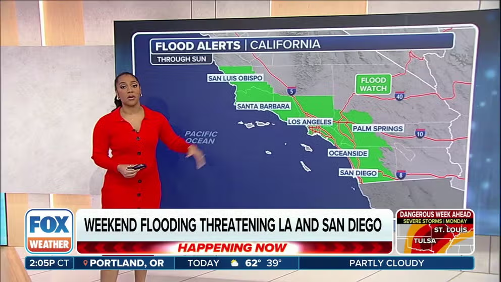
Easter weekend rain to impact Los Angeles, San Deigo
A storm system impacting California promises to deliver heavy rainfall and mountain snow through the holiday weekend. FOX Weather meteorologist Kiyana Lewis has the latest video forecast.
LOS ANGELES – Another soggy chapter is unfolding in the Golden State as heavy rain and mountain snow drench nearly the entire state, with weather alerts in effect for millions of residents.
A strong area of low pressure is swirling off the Northern California coast on its first stop in its three-day journey of drenching sections of the state.

(FOX Weather)
Steady rain was reported in the San Francisco Bay Area on Friday, with gusty winds that could reach up to 50 mph along the coast and hills.
As the storm pushes south toward the Los Angeles Basin, it is expected to tap into some tropical moisture, transitioning into a brief atmospheric river storm that will increase rainfall and flash flooding potential through the Easter holiday weekend.
CALIFORNIA’S ‘ARKSTORM’: HISTORIC 1000-YEAR FLOODS OF 1861-62 FEATURED 8 WEEKS OF ATMOSPHERIC RIVERS
"The bulk of moisture on the southern side (of the storm) is getting sucked right in, thrown into Southern California," FOX Weather Meteorologist Bob Van Dillen said. "Spots that don’t need rain are going to get it again."
As much as 1.5-3 inches of rain is likely up and down coastal Southern California, including the Los Angeles Basin and San Diego area. Higher totals of 3-6 inches are likely in the foothills and mountains.

(FOX Weather)
"You’re talking a lot of rain here, and you’re working up against these mountain faces that allow a ton of rain to wring out over Southern California," FOX Weather Meteorologist Britta Merwin said.
As a result, much of Southern California is now under a Flood Watch through the weekend.

(FOX Weather)
In addition, rainfall rates are forecast to reach 0.25-0.50 inches per hour across the region, with up to 0.75-1.0 inches per hour possible in locally heavier downpours and thunderstorms.
NOAA’s Weather Prediction Center has placed many urban areas in South California in a Level 2 out of 4 risk for flash flooding.
"I would be prepared for it," Merwin said. "I don’t think it’s a question of ‘if’ we will flood, but ‘where’ we will flood. Be very cognizant of what’s going on."

(FOX Weather)
"Roadway flooding will be a particular hazard on Saturday," the National Weather Service in Los Angeles warned. "So if you are planning to travel into or out of southern and central California, plan for more time to reach your destination over the weekend."
Strong thunderstorms keep the active weather going Sunday
The bulk of the steady, moderate-to-heavy rains will roll through Southern California on Saturday with the storm's cold front. But once the front passes, the atmosphere will become unstable as cold air aloft moves into the region. That will trigger possible thunderstorms on Saturday night into Sunday, with even a low chance of severe weather, including torrential downpours, quarter-sized hail, strong wind gusts and even the possibility of a weak tornado or waterspout.
"This is the classic setup where we can see isolated severe weather for Southern California," Merwin said. "That cold air present (aloft) is going to bring in a risk of thunderstorms … We shouldn’t be shocked if we see some hail."
Rockslides and mudslides, which have been a recurring problem throughout the soggy winter, remain possible as the ground remains saturated. Downtown Los Angeles has had nearly double its average rainfall since the start of the year, and February was among the top 10 wettest on record.
Winds will gust to 20-40 mph, with some isolated gusts to 45-60 mph over the Santa Lucia Mountains, where a High Wind Watches and Warnings remains in effect Friday.

(FOX Weather)
Higher elevations to get another heavy coating of snow
"Nothing says spring like snow and blowing snow in the mountains," the NWS in Los Angeles said Wednesday.
Heavy snow will fall in the higher elevations of the Southern California mountains this weekend, with 2-6 inches likely above 4,500 feet and 12-24 inches likely above 6,500 feet. There is even a low chance of snow along Interstate 5's Tejon Pass in the Grapevine.
"Traveling up and down from the mountains — both in the Sierra and also the Southern California mountains, it is not going to be fun," Merwin said. "And of course, this is the weekend that you want to do it. So be smart and be safe."
Snow will also pile up in the Sierra Nevada, where a few feet of snow will add to the snowpack that now sits at 101% of average statewide.
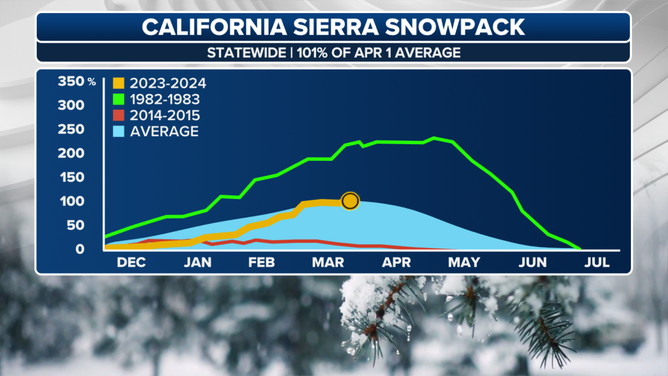
Statewide chart showing recovery of snowpack in California this year.
(FOX Weather)
"This has been one of the most remarkable snowpack recoveries we have seen in modern history in California," the FOX Forecast Center said. "The statewide snowpack was a mere 28% of normal on Jan. 1 and 53% of normal on Feb. 1, before the storm train kicked into gear."
Southern California is expected to dry out early next week as the storm track instead returns to the Pacific Northwest, but long-range forecasts show another storm eyeing California toward next weekend.
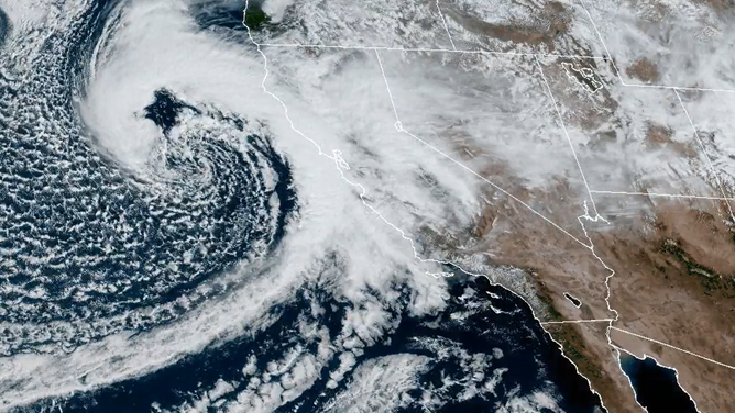
Satellite picture of storm system impacting California on Good Friday
(NOAA)