Paralyzing lake-effect snow continues to pummel Great Lakes, dumps more than 40 inches amid arctic blast
The city of Erie, Pennsylvania, reported its snowiest day on record Friday with a whopping 22.6 inches before eclipsing 2 feet by Saturday. Saybrook, Ohio, was at 49 inches as of Sunday. In New York, Barnes Corners and Copenhagen reached 46 inches of snow on the eastern end of Lake Ontario.

Record lake-effect snow totals blanketing Ohio, Michigan
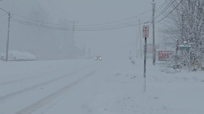
The lake-effect snow is in overdrive through Tuesday for the Great Lakes with feet of snow falling, causing travel nightmares across the region. Several cities in Ohio, New York and Michigan recorded their snowiest days ever over the weekend.
BUFFALO, N.Y. – Paralyzing amounts of snow are continuing to smother towns along the eastern shores of the Great Lakes as a record-breaking lake-effect snowstorm blasts the region, prompting major road closures and travel bans.
As of Sunday, snowfall totals have exceeded 3 feet downwind of Lake Erie in parts of northwestern Pennsylvania’s Erie County and western New York south of Buffalo and downwind of Lake Ontario in northern New York, and an additional 1-2 feet of snow is possible before the storm begins to wind down.
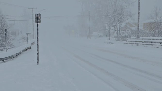
With snow falling between 1 and 4 inches an hour, accumulations overwhelmed efforts to keep roads clear under the heaviest bands.

Epic lake-effect snowstorm buries western New York cities in feet of snow
Western New York has been plagued with at least three feet of snow in some areas, amid lake-effect snow warnings. The National Weather Service office in Buffalo, New York, expected some snowfall totals to top 4 feet by Monday, and in some of the embedded snow bands, thundersnow and waterspouts were reported.
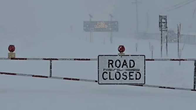
Interstate 90 was closed in both directions across Erie County, Pennsylvania, where the neighborhood of North East reported over 43 inches as of Sunday morning, and other nearby towns exceeded 3 feet.
The I-90 closure extended into New York state, but Gov. Kathy Hochul said late Saturday afternoon that the westbound lanes from Exit 57 to the Pennsylvania state line reopened to passenger traffic. However, a commercial travel ban remains in effect from Exit 46 to the Pennsylvania state line.
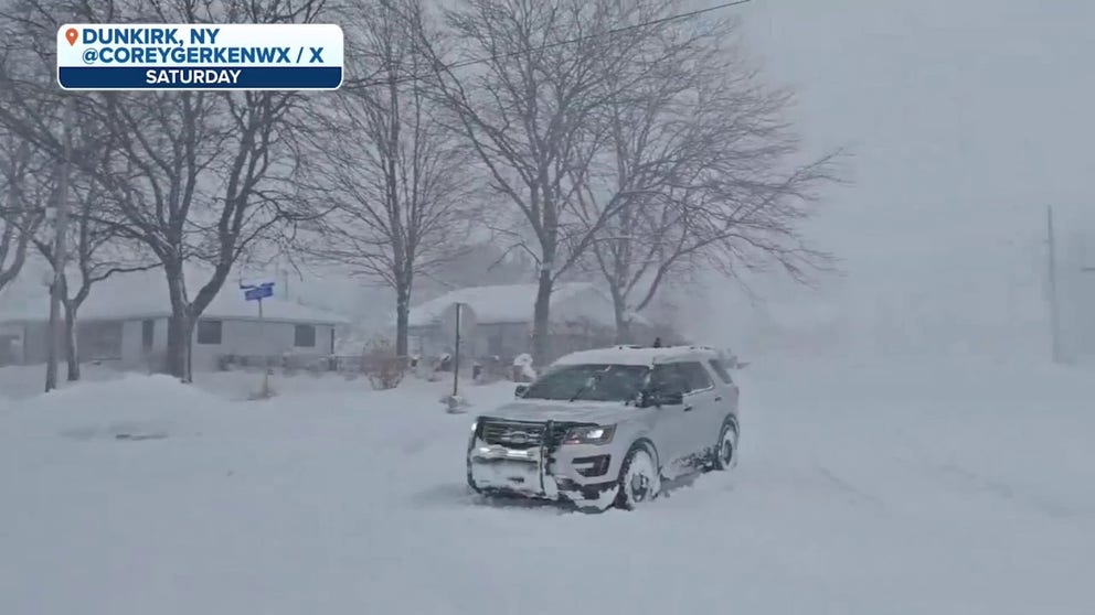
Watch: Crippling snow falls in Dunkirk, New York
The lake-effect snowstorm that has blasted the Great Lakes region is continuing on Sunday, and video shot from over the weekend shows crews hard at work removing snow from roads while other vehicles struggle to get around.
Interstate 86 was also closed near Erie, Pennsylvania, and New York officials issued travel bans in Dunkirk, Fredonia and Pomfret.
"We have been working tirelessly to keep Route 5 open in the Dunkirk area, however, over 100 vehicles had to be towed from Route 5 to make it possible for our plows to get through," New York State DOT officials posted on X. "THIS is why we ask that you stay off the roads if you do not have to travel!"
FOX Weather Storm Tracker Brandon Copic said even smaller passenger vehicles were having a tough time maneuvering through the snow and rescues were taking place.

Watch: Plows working hard to clear snow from Pennsylvania roads
A video shared by FOX Weather Exclusive Storm Tracker Brandon Copic shows crews hard at work trying to clear snow from US 20 in Fairview, Pennsylvania, on Sunday morning.
"Honestly, it’s just chaos out here," Copic said Saturday. "The trucks are going on roads they shouldn’t be going because the highways are closed, and that just leads to more cars getting stranded. I spent 15 hours Friday night helping people … doing what I can to assist those who are stuck."
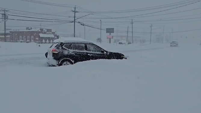
Copic sent his drone above Pennsylvania's State Route 5 near the New York border around noon Saturday to find an epic gridlock of dozens of vehicles stuck in the snow.

FOX Weather Storm Trackers help rescue stuck driver as snow pours along Erie highway
Storm trackers Corey Gerken and Brandon Copic teamed up along a very snowy interstate in Erie County, Pennsylvania to help pull a car stuck along the shoulder. "This was the third car we've rescued today so far," Gerken said.
"The trucks that are jackknifed up the road is what caused the gridlock," Copic said, estimating that most of the vehicles have been stranded there since Friday.

Traffic remains gridlocked on side roads in Erie County as snow clogs highways
FOX Weather Storm Tracker Brandon Copic shows drone video of State Route 5 in Erie County near the Pennsylvania/New York border where multiple trucks and vehicles have been stranded for hours.
New York Gov. Kathy Hochul declared a state of emergency for nearly a dozen upstate counties as crews braced for the long-duration event, while in Pennsylvania, Gov. Josh Shaprio has activated the state's National Guard to assist with stranded drivers and help emergency vehicles respond to calls.
Erie County Executive Brenton Davis declared a snow disaster. "Roads are dangerous, and travel is strongly discouraged except for emergencies," Davis' proclamation read.
Traffic trouble on I-90 extended east of Cleveland on Sunday, and multiple crashes caused delays as lake-effect snow continued to dump on North Central Ohio.
![Heavy Snow Falls in Fredonia, NY]() Image 1 of 10
Image 1 of 10Heavy snow falls in Fredonia, New York, on Nov. 30, 2024. ( )
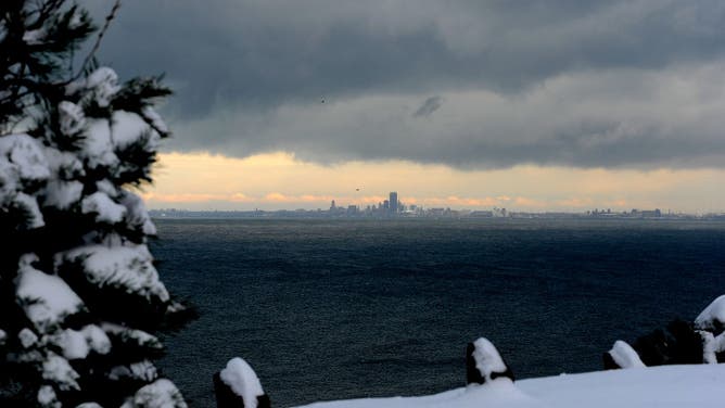
![Lake effect snow clouds hang over Lake Erie and the Buffalo skyline December 1, 2024 as seen from Hamburg, New York.]() Image 2 of 10
Image 2 of 10Lake effect snow clouds hang over Lake Erie and the Buffalo skyline December 1, 2024 as seen from Hamburg, New York. The North Eastern storm that closed a ninety-mile stretch of The New York State Thruway and snarled holiday traffic across the country dumped more than four feet of snow around Buffalo and its southern suburbs and is expected to continue throughout the weekend. (Photo by John Normile/Getty Images) ( )
![Heavy Snow Falls in Fredonia, NY]() Image 3 of 10
Image 3 of 10Heavy snow falls in Fredonia, New York, on Nov. 30, 2024. ( )
![Lake Effect Snow In Mayville NY]() Image 4 of 10
Image 4 of 10Lake-effect snow in Mayville, New York, on Nov. 29, 2024. ( )
![Lake Effect Snow In Mayville NY]() Image 5 of 10
Image 5 of 10Lake-effect snow in Mayville, New York, on Nov. 29, 2024. ( )
![]() Image 6 of 10
Image 6 of 10Lake-effect snow closures. ( )
![Lake Effect Snow In Gaylord Michigan]() Image 7 of 10
Image 7 of 10Lake-effect snow falls in Gaylord, Michigan, on Nov. 29, 2024. (National Weather Service, Gaylord, Mich.)
![Heavy snow falls in Erie, Penn.]() Image 8 of 10
Image 8 of 10Heavy lake-effect snow falls in Erie, Pennsylvania, on Nov. 29, 2024. (Cory Gerkhin)
![Traffic and crashes near Mentor, Ohio on I-90 on Sunday, Dec. 1, 2024.]() Image 9 of 10
Image 9 of 10Traffic and crashes near Mentor, Ohio on I-90 on Sunday, Dec. 1, 2024. (Brandon Copic)
![Traffic and crashes near Mentor, Ohio on I-90 on Sunday, Dec. 1, 2024.]() Image 10 of 10
Image 10 of 10Traffic and crashes near Mentor, Ohio on I-90 on Sunday, Dec. 1, 2024. (Brandon Copic)
Erie, Pennsylvania, and Gaylord, Michigan, set daily snowfall records
Nearly 2.9 million remain under a Lake-Effect Snow Warning through at least Monday across parts of western and northern New York, northwestern Pennsylvania and northeastern Ohio as lakes Erie and Ontario crank up the snow-making machine. A variety of Winter Storm Warnings and Winter Weather Advisories cover prone areas of Michigan.

(FOX Weather)
Arctic air continues to pour out of Canada and is sweeping across the Great Lakes, which are currently experiencing record-warm water temperatures.
The city of Erie, Pennsylvania, reported its snowiest day on record Friday with a whopping 22.6 inches before eclipsing 2 feet by Saturday.
Saybrook, Ohio was at 49 inches as of Sunday. In New York, Barnes Corners and Copenhagen reached 46 inches of snow on the eastern end of Lake Ontario.

(FOX Weather)
Over in Michigan, 26.2 inches have fallen in Sault Ste. Marie, while Gaylord reported 33.8 inches as of Sunday.
The 24.8 inches that fell in Gaylord on Friday alone vaulted Nov. 29 to the city's snowiest calendar day on record.

(FOX Weather)
How much snow is expected around Buffalo off Lake Erie?
The city of Buffalo had been included in the Lake-Effect Snow Warning, but that has since been dropped as of Sunday morning.
However, communities south of Buffalo remain under the warning and could see an additional 1-2 feet of snow through Monday under the most intense snow bands.
"During lake effect snow, the weather can vary from bands of locally heavy snow with greatly reduced visibilities to dry conditions just a few miles away," the NWS in Buffalo said. "Be prepared for rapid changes in weather, visibility and road conditions."

(FOX Weather)
The Lake-Effect Snow Warning includes Orchard Park, where the Buffalo Bills took on the San Francisco 49ers for Sunday Night Football.
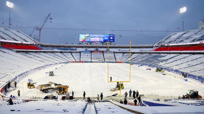
Crews work to clear snow from the field before a game between the Buffalo Bills and the San Francisco 49ers at Highmark Stadium on December 01, 2024 in Orchard Park, New York. (Photo by Timothy T Ludwig/Getty Images)
(Getty Images)
Weather observers in Orchard Park measured storm totals between 20 and 23 inches of snow on Sunday morning, and the FOX Forecast Center said another few inches was possible before the snow band shifted farther south and away from Highmark Stadium.
Fans and teams at Highmark Stadium worked ahead of the game to clear snow from the field and the stands.
‘Extreme’ band of snowfall expected around Watertown off Lake Ontario

(FOX Weather)
The ongoing intense band of snow will wobble north and south of the Watertown area through Monday. This band will be extreme, at times capable of snow rates up to 4 inches per hour and thundersnow.
The highest snow totals from the event will be found in this region, where a bull's-eye of 4-6 feet of snow is possible somewhere from the northern Tug Hill Plateau to near or in Watertown.
PARALYZING GREAT LAKES SNOWSTORM PRODUCES RARE THUNDERSNOW, WATERSPOUTS
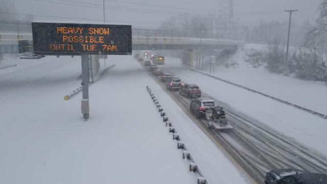
How much more snow is expected near Cleveland and Erie?
The area stretching from Ashtabula, Ohio, through Erie, Pennsylvania, and into Mayville, New York, was hit the hardest Friday, and more snow is on the way into the start of the workweek. Forecasts indicate still another 8-12 inches is possible around Erie, Pennsylvania, and even northeastern Ohio.
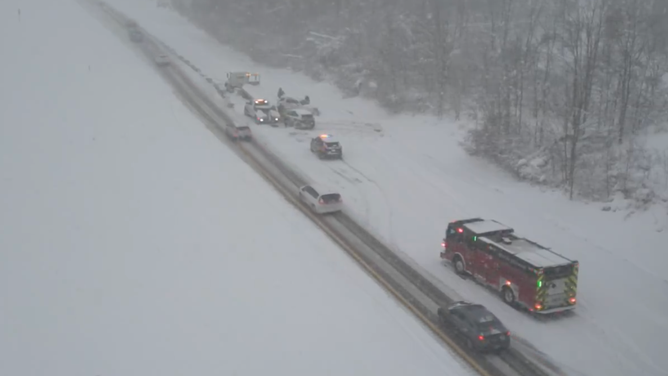
Traffic and crashes near Mentor, Ohio on I-90 on Sunday, Dec. 1, 2024.
(Brandon Copic / FOX Weather)
Storm-total snowfall may be as high as 3-4 feet somewhere from the Chautauqua County shoreline in southwestern New York into southern Erie County in Pennsylvania, and perhaps even some of the more distant Southtowns of Buffalo.

(FOX Weather)
The Cleveland area was in the clear Saturday but is now under a Lake-Effect Snow Warning for a renewed round of lake-effect snow from Sunday afternoon into Tuesday morning. Snowfall totals will be between 6 and 14 inches near the lake and up to the northeast of the metro area.
The NWS Cleveland forecast an additional 10 to 18 inches of snow is possible across Lake and northern Ashtabula counties through Tuesday.

(FOX Weather)
How much more snow will fall across Michigan's Upper Peninsula?
Heavy snow is also plastering Michigan’s Upper Peninsula and western Lower Michigan as the cold winds blow off Lake Superior and Lake Michigan.
Multiple bands of lake-effect snow will continue through the end of the weekend. These bands won't contain snow rates quite as high as those in the eastern lakes – closer to 1-2 inches per hour.

Lake-effect snow falls in Gaylord, Michigan on Nov. 29, 2024.
(National Weather Service, Gaylord, Mich. / NOAA)
But they'll still be heavy enough to lead to near-whiteout conditions and exceptionally dangerous travel conditions. The heaviest snow will be found across the Upper Peninsula and the western Lower Peninsula of Michigan. Up to 2 feet has already fallen, and another 1-2 feet is on the way.
"Snow is fluffy but wet," forecasters at the NWS office in Gaylord, Michigan, said Friday morning as the snow came down. "If you run into one of these, it will quickly be discombobulating."
Record water temperatures fueling big snow totals

Great Lakes temperature departures.
(FOX Weather)
With Great Lakes water temperatures running 4-6.5 degrees above average, the arctic winds are picking up the warmth and moisture from the waters and transfer it into the lowest portion of the Earth’s atmosphere.
WHAT MAKES A LAKE-EFFECT SNOWSTORM?
This rising air condenses into clouds, which can grow into narrow bands that are capable of producing snowfall rates on the order of 2-3 inches per hour or more, according to the National Weather Service. But snow squalls usually fall in bands that can lead to highly variable snow totals over short distances.
"It really a lot of it has to do with the (winds) running down the length of the lake," NWS Buffalo Lead Meteorologist Kirk Apffel told FOX Weather. "And sometimes you have a favored area where it will converge, come together, and that's when you can get some of those most intense bands. And when it's not running down the length of the lake, sometimes things tend to be more disorganized with multiple bands. So it is something that we can forecast, but it is challenging."

Potent lake-effect snow event ramping up around the Great Lakes over the weekend
NWS Buffalo lead forecaster Kirk Apffel joins FOX Weather to talk about the heavy snows coming to western New York including parts of Buffalo due to a strong lake-effect snow event starting Friday and lasting for days.
The lake-effect snow squalls are expected to last through the middle of this week until another weather system changes the wind direction. Suffice it to say, it will be a very wintry week of weather along the Great Lakes.
In addition, the coldest air of the season will sweep across the eastern half of the nation, with around 230 million Americans feeling below-average temperatures into the start of the new workweek.