Severe storms threaten northern Plains, Upper Midwest, Southeast on Thursday
Flash flooding is also a concern in parts of the Southeast, where the storms will contain locally heavy downpours
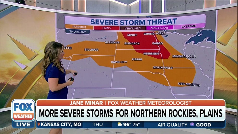
Northern Plains and Upper Midwest brace for more severe weather Thursday
Only a handful of the very strongest storms could produce 60+ mph winds. The majority of the storms will be far less impactful.
A new weather disturbance punching into the northern Plans and Upper Midwest will help trigger another round of severe weather on Thursday as strong thunderstorms also remain a threat across the Southeast.
To the north of a relentless heat wave searing much of the central U.S., a kink in the jet stream will round the top of a massive high-pressure system responsible for the dangerously hot temperatures, sweeping from Montana into North Dakota during the day and then across Minnesota overnight.
This upper-level feature will provide the instability needed for thunderstorm development in the northern Plains and Upper Midwest beginning late Thursday afternoon.
"We do have a possibility of storms that stretches as far east as Minneapolis and back towards the west into Billings and Glendive, Montana," said FOX Weather meteorologist Jane Minar.
HOW TO WATCH FOX WEATHER ON TV
Meanwhile, a tropical air mass remains in place across the Southeast as a southward plunge of the jet stream sits just north of the region. Cooler air associated with that jet stream dip to the north will interact with the tropical moisture and fuel scattered to numerous storms Thursday afternoon and evening through about sunset.
Here's a closer look at what to expect from any thunderstorms over the next few days.

(FOX Weather)
Thursday
Severe thunderstorms with large hail and damaging winds are possible across parts of the northern Plains and Upper Midwest from late Thursday afternoon through the evening.
"A likely risk for those storms is going to develop across eastern North Dakota into northeastern South Dakota," Minar said. "Aberdeen, Fargo and Minot are places that you really want to make sure those FOX Weather alerts are turned on as we get into the afternoon and evening."
An isolated wind-damage threat might also develop in parts of the Carolinas, Georgia and Florida during the afternoon before diminishing around sunset. Flash flooding is another concern in these areas, as the storms will contain locally heavy downpours fueled by an injection of tropical moisture from the Gulf of Mexico.
NEW COLD FRONT ARRIVES TO RENEW TORRENTIAL TROPICAL DOWNPOURS IN THE SOUTHEAST

(FOX Weather)
Friday
Isolated severe thunderstorms capable of producing damaging winds and hail are possible across parts of the northern High Plains on Friday.
Other storms with locally strong wind gusts are also possible in parts of the Upper Midwest.
THIS IS AMERICA'S MOST ACTIVE TIME FOR DAMAGING WINDS FROM SEVERE THUNDERSTORMS

(FOX Weather)
Saturday
Thunderstorms associated with locally damaging winds and isolated large hail are possible across parts of the northern Plains on Saturday.
CLICK HERE TO GET THE FOX WEATHER UPDATE PODCAST

(FOX Weather)
Be sure to download the FOX Weather app to track any storms in your area and receive potentially life-saving weather alerts issued by the National Weather Service. The free FOX Weather livestream is also available 24/7 on the website and app and on your favorite streaming platform. The FOX Weather Update podcast also provides weather information for the entire country.