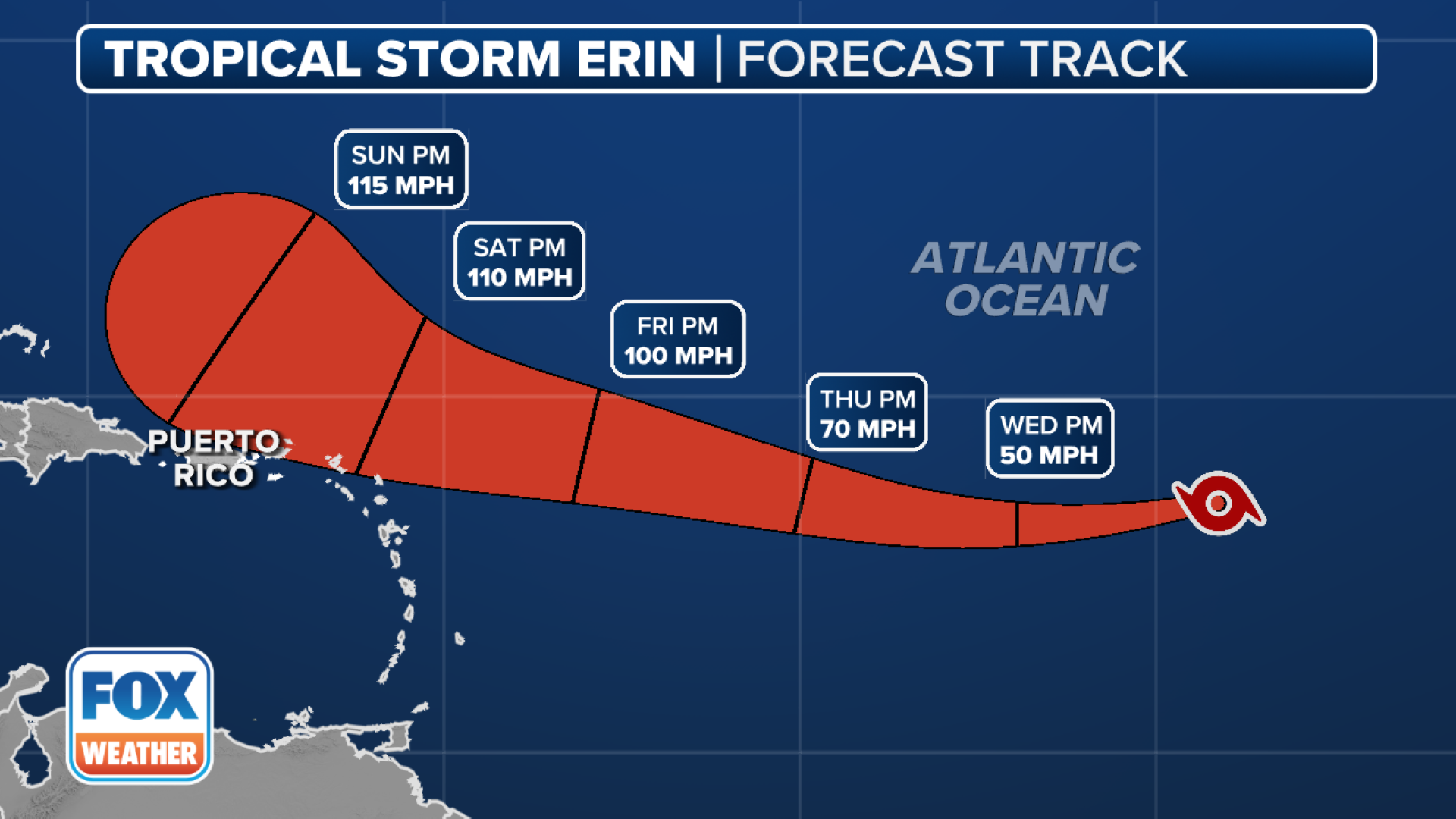
Hurricane Erin’s big waves, flooding risks shift to Northeast coast after slamming mid-Atlantic
Beaches remained off limits to swimming up and down the East Coast as dangerous waves and potentially deadly rip currents angrily pounded the shorelines. Bermuda is under a Tropical Storm Warning and a state of emergency is underway in New Jersey.

Hurricane Erin batters East Coast as impacts shift to Northeast coast
FOX Weather Hurricane Specialist Bryan Norcross joins Ian Oliver to talk about the latest information on Hurricane Erin. As of Thursday evening, the powerful storm remains a Category 2 hurricane with 100 mph winds and producing dangerous conditions in the Northeast through Friday.
HATTERAS, N.C. – Powerful Hurricane Erin continued lashing hundreds of miles of the Northeast coastline on Thursday after creating big waves and coastal flooding in the Mid-Atlantic. The sprawling hurricane is now turning northeast toward Bermuda and continues to bring widespread coastal impacts to the East Coast.
Tens of thousands had been evacuated off the most vulnerable of North Carolina's Outer Banks as a storm surge of up to 4 feet was likely. Meanwhile, beaches remained off limits to swimming up and down the East Coast as dangerous waves and potentially deadly rip currents angrily pounded the shorelines.

Hurricane Erin batters North Carolina's Outer Banks with monster waves, tropical-storm-force winds
FOX Weather Storm Specialist Mike Seidel reports live from Kitty Hawk, North Carolina, where the outer rain bands of Hurricane Erin are battering the Outer Banks with tropical-storm-force winds and monster waves that could reach upwards of 17 feet.
Hurricane Erin was still a Category 2 storm with maximum sustained winds of 100 mph on Thursday evening.
While the center of Erin and its peak winds were some 300 miles east of Cape Hatteras, North Carolina, tropical-storm-force winds extended outward up to 320 miles, reaching parts of the North Carolina and Virginia coastlines, where Tropical Storm Warnings lingered into Thursday.
The Bermuda Weather Service issued a Tropical Storm Warning for the island.
According to the National Hurricane Center, a weather station at Jennette's Pier in Nags Head, North Carolina, measured sustained winds of 45 mph and a gust of 54 mph on Thursday morning.

(FOX Weather)
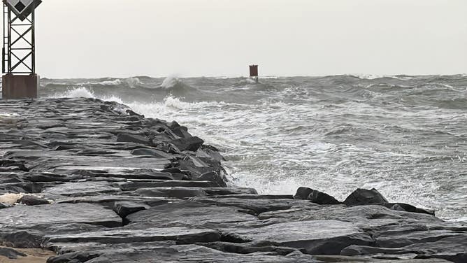
The greatest impacts from Erin were focused on the central Outer Banks, where waves of up to 20 feet combined with a storm surge of 2-4 feet continued to overwhelm some of the barrier islands.
North Carolina Department of Transportation crews had to shut down Highway 12 – the main road along the Outer Banks – from Oregon Inlet to Hatteras Village Wednesday evening as the encroaching surf began covering the road.
TRACK HURRICANE ERIN: LIVE EAST COAST RIP CURRENT THREAT, MAPS, FORECAST CONE
![Rough surf in Ocean City, Maryland on Aug. 21, 2025 due to Hurricane Erin.]() Image 1 of 26
Image 1 of 26Rough surf in Ocean City, Maryland on Aug. 21, 2025 due to Hurricane Erin. (Brandy Campbell)
![Large waves in Ocean City, Maryland on Aug. 21, 2025.]() Image 2 of 26
Image 2 of 26Large waves in Ocean City, Maryland on Aug. 21, 2025. (Brandy Campbell)
![North Carolina Highway 12 Closed]() Image 3 of 26
Image 3 of 26Heavy surf and storm surge from Hurricane Erin shut down North Carolina's Highway 12 on Aug. 20, 2025. (NC Dept. of Transportation)
![North Carolina Highway 12 Closed]() Image 4 of 26
Image 4 of 26Heavy surf and storm surge from Hurricane Erin shut down North Carolina's Highway 12 on Aug. 20, 2025. (NC Dept. of Transportation)
![Overwash in Hatteras Island, North Carolina as Hurricane Erin's biggest impacts begin on Wednesday, Aug. 20, 2025.]() Image 5 of 26
Image 5 of 26Overwash in Hatteras Island, North Carolina as Hurricane Erin's biggest impacts begin on Wednesday, Aug. 20, 2025. (Jenni Koontz/Epic Shutter Photography/Dare County)
![Overwash in Hatteras Island, North Carolina as Hurricane Erin's biggest impacts begin on Wednesday, Aug. 20, 2025.]() Image 6 of 26
Image 6 of 26Overwash in Hatteras Island, North Carolina as Hurricane Erin's biggest impacts begin on Wednesday, Aug. 20, 2025. (Jenni Koontz/Epic Shutter Photography/Dare County)
![Overwash in Hatteras Island, North Carolina as Hurricane Erin's biggest impacts begin on Wednesday, Aug. 20, 2025.]() Image 7 of 26
Image 7 of 26Overwash in Hatteras Island, North Carolina as Hurricane Erin's biggest impacts begin on Wednesday, Aug. 20, 2025. (Jenni Koontz/Epic Shutter Photography/Dare County)
![Overwash in Hatteras Island, North Carolina as Hurricane Erin's biggest impacts begin on Wednesday, Aug. 20, 2025.]() Image 8 of 26
Image 8 of 26Overwash in Hatteras Island, North Carolina as Hurricane Erin's biggest impacts begin on Wednesday, Aug. 20, 2025. (Jenni Koontz/Epic Shutter Photography/Dare County)
![Red "No Swimming" flags are seen in Brighton Beach amid Hurricane Erin on August 20, 2025 in the Coney Island neighborhood of the Brooklyn borough in New York City. NYC Mayor Eric Adams and Iris Rodriguez-Rosa, the parks commissioner, announced that city beaches would be closed for several days as rip currents and rough waters are expected along the East Coast due to Hurricane Erin.]() Image 9 of 26
Image 9 of 26Red "No Swimming" flags are seen in Brighton Beach amid Hurricane Erin on August 20, 2025 in the Coney Island neighborhood of the Brooklyn borough in New York City. NYC Mayor Eric Adams and Iris Rodriguez-Rosa, the parks commissioner, announced that city beaches would be closed for several days as rip currents and rough waters are expected along the East Coast due to Hurricane Erin. Lifeguards will not be on duty during the closures but will be stationed along the coastline along with members of the Parks Enforcement Patrol to prevent people from attempting to swim. (Michael M. Santiago)
![Storm preps in Ocean City, Maryland]() Image 10 of 26
Image 10 of 26Heavy surf pounds the shores of Ocean City, Maryland ahead of Hurricane Erin's passby later this week. (Brandy Campbell)
![Overwash in Hatteras Island, North Carolina as Hurricane Erin's biggest impacts begin on Wednesday, Aug. 20, 2025.]() Image 11 of 26
Image 11 of 26Overwash in Hatteras Island, North Carolina as Hurricane Erin's biggest impacts begin on Wednesday, Aug. 20, 2025. (Jenni Koontz/Epic Shutter Photography/Dare County)
![]() Image 12 of 26
Image 12 of 26Winds whip sand into people's faces in Nags Head, North Carolina, during Erin's trek up the coast. (Katie Byrne)
![]() Image 13 of 26
Image 13 of 26Waves crash on the shores of Manasquan, New Jersey on Thursday morning. (Christian Miller)
![Beach life mostly returned to normal on Isle of Palms, South Carolina on Thursday, Aug. 21, 2025 after Hurricane Erin passed the Carolina coast.]() Image 14 of 26
Image 14 of 26Beach life mostly returned to normal on Isle of Palms, South Carolina on Thursday, Aug. 21, 2025 after Hurricane Erin passed the Carolina coast. (Robert Ray)
![Beach life mostly returned to normal on Isle of Palms, South Carolina on Thursday, Aug. 21, 2025 after Hurricane Erin passed the Carolina coast.]() Image 15 of 26
Image 15 of 26Beach life mostly returned to normal on Isle of Palms, South Carolina on Thursday, Aug. 21, 2025 after Hurricane Erin passed the Carolina coast. ( )
![Beach life mostly returned to normal on Isle of Palms, South Carolina on Thursday, Aug. 21, 2025 after Hurricane Erin passed the Carolina coast.]() Image 16 of 26
Image 16 of 26Beach life mostly returned to normal on Isle of Palms, South Carolina on Thursday, Aug. 21, 2025 after Hurricane Erin passed the Carolina coast. ( )
![Beach life mostly returned to normal on Isle of Palms, South Carolina on Thursday, Aug. 21, 2025 after Hurricane Erin passed the Carolina coast.]() Image 17 of 26
Image 17 of 26Beach life mostly returned to normal on Isle of Palms, South Carolina on Thursday, Aug. 21, 2025 after Hurricane Erin passed the Carolina coast. (Robert Ray)
![Ocean City, Maryland]() Image 18 of 26
Image 18 of 26Rough surf in Ocean City, Maryland on Aug. 21, 2025 due to Hurricane Erin. (Brandy Campbell)
![Rough surf in Ocean City, Maryland on Aug. 21, 2025 due to Hurricane Erin.]() Image 19 of 26
Image 19 of 26Rough surf in Ocean City, Maryland on Aug. 21, 2025 due to Hurricane Erin. (Brandy Campbell)
![Rough surf in Ocean City, Maryland on Aug. 21, 2025 due to Hurricane Erin.]() Image 20 of 26
Image 20 of 26Rough surf in Ocean City, Maryland on Aug. 21, 2025 due to Hurricane Erin. (Brandy Campbell)
![Rough surf in Ocean City, Maryland on Aug. 21, 2025 due to Hurricane Erin.]() Image 21 of 26
Image 21 of 26Rough surf in Ocean City, Maryland on Aug. 21, 2025 due to Hurricane Erin. (Brandy Campbell)
![Rough surf in Ocean City, Maryland on Aug. 21, 2025 due to Hurricane Erin.]() Image 22 of 26
Image 22 of 26Rough surf in Ocean City, Maryland on Aug. 21, 2025 due to Hurricane Erin. (Brandy Campbell)
![Rough surf in Ocean City, Maryland on Aug. 21, 2025 due to Hurricane Erin.]() Image 23 of 26
Image 23 of 26Rough surf in Ocean City, Maryland on Aug. 21, 2025 due to Hurricane Erin. (Brandy Campbell)
![Rough surf in Ocean City, Maryland on Aug. 21, 2025 due to Hurricane Erin.]() Image 24 of 26
Image 24 of 26Rough surf in Ocean City, Maryland on Aug. 21, 2025 due to Hurricane Erin. (Brandy Campbell)
![Rough surf in Ocean City, Maryland on Aug. 21, 2025 due to Hurricane Erin.]() Image 25 of 26
Image 25 of 26Rough surf in Ocean City, Maryland on Aug. 21, 2025 due to Hurricane Erin. ( )
![NOAA satellite imagery shows Hurricane Erin off the U.S. Atlantic Coast on Thursday, Aug. 21, 2025.]() Image 26 of 26
Image 26 of 26NOAA satellite imagery shows Hurricane Erin off the U.S. Atlantic Coast on Thursday, Aug. 21, 2025. (NOAA)


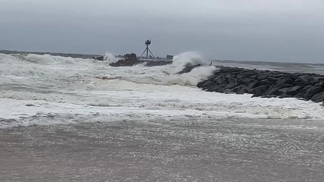


"Unfortunately, Hurricane Erin's storm surge was too much for NC12 tonight," NCDOT officials wrote. "Conditions are too unsafe for people to be driving in."
Much of the roadway was supposed to be empty anyway as officials in Dare, Hyde and Currituck counties declared local states of emergency and issued mandatory evacuation orders for tourists and residents in popular areas like Ocracoke Island and Hatteras Island. Dare County officials told FOX Weather Correspondent Katie Byrne that some 85,000 people had heeded their orders and left by Wednesday.
"I'm a little worried for the people down in Hatteras and Rodanthe, Waves and Salvo and all that stuff," said Jaden Howard, who lives in Nags Head. "I saw videos of the (surf); it's already washed over the road down there. There's one way in, one way out … The scary part is it's not what happens during the storm, it's how are they going to travel after the storm."

Watch: Drone video shows monster waves, storm surge on North Carolina's Outer Banks
A dramatic drone video shows large waves and storm surge swallowing homes in Buxton, North Carolina, as powerful Hurricane Erin spins off the U.S. East Coast on Aug. 19.
North Carolina Gov. Josh Stein, who declared a state of emergency Wednesday for the affected region, said that anyone who defied an evacuation order and remained in areas vulnerable to coastal flooding and storm-surge flooding was putting their lives at risk.
"When there is a major storm, when there is flooding, there is a great risk of death," he warned. "And what we don’t want is for people to die."
NHC'S JAMIE RHOME JOINS BRYAN NORCROSS TO ANSWER QUESTIONS ON HURRICANE ERIN

(FOX Weather)
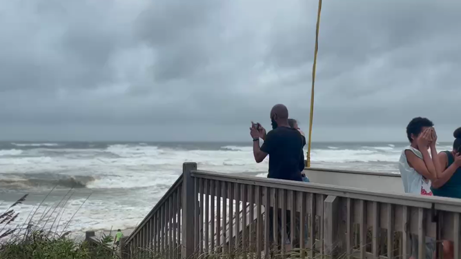
Big waves building in Northeast as Hurricane Erin's impacts shift north through Friday
While Hurricane Erin's path was pulling it farther away from the mid-Atlantic coast on Thursday as it headed out toward the open waters of the North Atlantic, its arc was still going to nudge close enough to parts of the northern mid-Atlantic and Northeast coasts to bring dangerous beach conditions and strong winds even into Friday.

(FOX Weather)
Among those areas feeling impacts will be the Tidewater region of Virginia, the Delmarva Peninsula, the Jersey Shore, Long Island, New England and Atlantic Canada, the FOX Forecast Center said.
With beaches closed in Ocean City, Maryland, many onlookers came out to see the powerful seas under Erin's influence on Thursday, but from a safe distance.

Maryland beaches walloped by strong winds and surf from Hurricane Erin
Beaches in Ocean City, Maryland, are closed as Hurricane Erin creates dangerous surf conditions offshore. FOx Weather Correspondent Brandy Campbell is on the beach where 40 mph winds and 10-foot waves were recorded Thursday morning.
New Jersey Gov. Phil Murphy issued a State of Emergency beginning Thursday afternoon due to dangerous flooding, surf and winds across the Jersey Shore.
"As the storm moves past New Jersey over the next 24 hours, we are expecting high surf and rip currents, coastal and flash flooding, and a high erosion risk in parts of the state. We ask all New Jerseyans to monitor local weather forecasts and warnings and stay informed on evacuation protocols, especially if you’re down the Shore," Murphy said.
Across the East Coast, this was the swell many surfers had been waiting all summer for. Some ocean rescue and lifeguards in New York and New Jersey opened the waters earlier on Thursday to experienced surfers.
In Long Beach, New York, waves were between 5 and 8 feet in the morning and forecast to increase by high tide Thursday evening.
Long Beach Chief of Lifeguards Rich Borawaski told FOX Weather Meteorologist Jane Minar that not everyone was allowed to ride the waves on Thursday.

Cat 2 Hurricane Erin brings swell for New Jersey, New York surfers
FOX Weather Meteorologist Jane Minar is in Long Beach, New York where experienced surfers are welcoming the waves created by Hurricane Erin. She spokes to Long Beach Chief Lifeguard Rich Borawaski who explained the surf rules for those hoping to ride these waves.
"If you come in the surf, you have to have the skill set, especially in these type of conditions, you have to have a leash," Borawaski said. "All the surfers have been great, and they have been following the rules."
Coastal Flood Warnings covered parts of Delaware, New Jersey and New York's Long Island into Friday, with as much as 2-3 feet of inundation in low-lying areas along the beaches and surf ranging from 7-16 feet.
Coastal vulnerability will be greatest at times of high tide, when elevated tides combine with large, powerful waves.
(FOX Weather)
The NHC said Erin will move over the western Atlantic between the U.S. east coast and Bermuda early Friday, before passing south of Atlantic Canada Friday and Saturday.