Weakening Tropical Storm Darby to bring weekend storms to Hawaii
Darby's tropical moisture will be pulled northward toward the Big Island on Saturday, resulting in widespread showers and thunderstorms to start the weekend
Darby weakens to a tropical storm, to bring rain to Hawaii
Weakening Tropical Storm Darby to bring weekend storms to Hawaii.
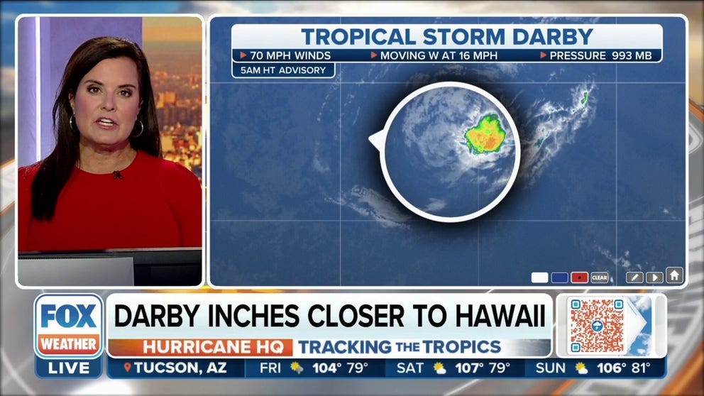
After rapidly intensifying into a Category 4 hurricane at the start of the week, Darby has now weakened to a tropical storm as it churns through the cooler Central Pacific waters southeast of Hawaii.
As of Friday morning, Tropical Storm Darby was located more than 600 miles east-southeast of Hilo, Hawaii, and was moving west at about 15 mph.
Darby is expected to follow a westward track for the next couple of days. However, the tropical storm will continue to weaken as it moves over cooler sea-surface temperatures in the Central Pacific.
HOW TO WATCH FOX WEATHER ON TV
Darby is predicted to become a post-tropical remnant area of low pressure late Saturday or Saturday night as it passes south of Hawaii.
Despite an expected track south of the Hawaiian Islands, Darby's tropical moisture will be pulled northward toward the Big Island on Saturday. This will result in widespread showers and thunderstorms to start the weekend.
There will also be high surf and an increased threat of dangerous rip currents throughout the weekend across much of the island chain.

(FOX Weather)
Cooler ocean waters tearing Darby apart
Luckily, Darby is located over waters in the Central Pacific that are too cool to sustain a tropical storm, as well as an area with strong upper-level winds that are not conducive to maintaining a tropical cyclone.
Therefore, forecasters expect Darby to feel the effects of this more hostile environment for the remainder of its lifecycle before the storm dissipates south of Hawaii on Sunday.
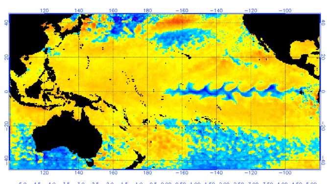
The cooler-than-average waters in parts of the Central Pacific and the increased upper-level winds are classic products of a La Niña that is in control of weather patterns.
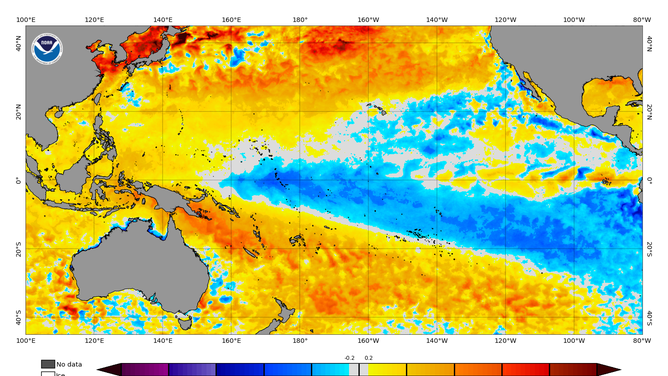
Patches of blue represent water temperatures that are below normal. Water temperatures that are above normal are in orange and red.
(NOAA)
According to recent satellite data, a large part of the real estate ahead of Darby has water temperatures in the mid- to upper 70s, which is considered too cool for tropical cyclone activity.
The National Weather Service says tropical cyclones generally need water temperatures above 80 degrees to form.
WHY DON'T TROPICAL STORMS OR HURRICANES EVER HIT CALIFORNIA?
History
Hurricane Darby rapidly intensified Sunday into early Monday while churning in the Eastern Pacific to the east of Hawaii, putting on a show for the weather satellites in space with a classic swirl punctuated by a distinct eye.

(FOX Weather)
According to the National Hurricane Center, rapid intensification occurs when a tropical cyclone's maximum sustained winds increase by at least 35 mph in a 24-hour period. In Darby's case, those criteria were easily met.
At 11 p.m. Hawaiian time Sunday, Darby was an 85-mph Category 1 hurricane, then it rapidly intensified into a 120-mph Category 3 hurricane by 3:15 a.m. Hawaiian time Monday – an increase of 35 mph in just over 4 hours.
Darby actually went on to double the 35-mph requirement for rapid intensification when its winds increased by 70 mph in a 24-hour period from Sunday into Monday. Michael Lowry, a hurricane and storm-surge expert and former strategic planner with FEMA, noted that less than 0.5% of all tropical/subtropical cyclones in the Eastern Pacific intensify that rapidly.
WHAT DOES IT MEAN WHEN A HURRICANE UNDERGOES ‘RAPID INTENSIFICATION’?
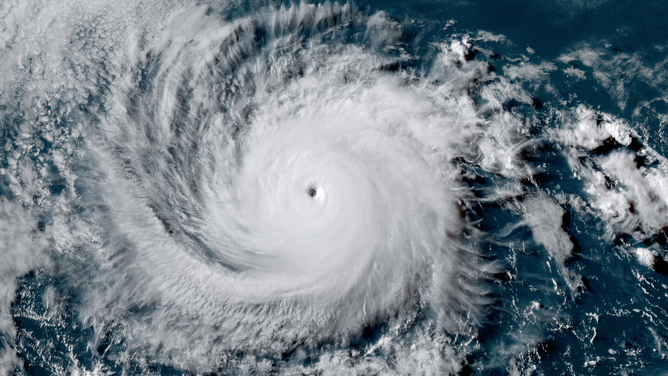
Category 4 Hurricane Darby as seen on July 11, 2022.
(NOAA / RAMM-B / CIRA)
But Darby refused to give up. It weakened to a Category 2 hurricane on Wednesday before regaining major hurricane status, Category 3, by Wednesday evening.
Darby weakened to a Category 2 hurricane once again Thursday morning and was barely hanging onto Category 1 strength Friday morning before weakening back to a tropical storm.
Hurricane Darby was the second major hurricane in the Eastern Pacific in less than a week.
Last Tuesday, Hurricane Bonnie intensified into a major hurricane a few hundred miles off the Pacific coast of Mexico. A major hurricane is defined as one that's rated Category 3 or higher on the Saffir-Simpson Hurricane Wind Scale.
Hawaii has a history with the "Darby" name
If you have heard the name "Darby" associated with hurricanes before, your mind is not playing tricks on you.
The World Meteorological Organization reuses tropical cyclone names every six years, as long as they don't meet the threshold for retirement.

(FOX Weather)
"Darby" has been used to name tropical cyclones in the Eastern Pacific for decades, but during its last showing in 2016, the system impacted Hawaii with torrential rains and gusty winds
Ocean temperatures and atmospheric conditions are quite different this year than six years ago. Then, Tropical Storm Darby made landfall on the Big Island on July 23 with winds of around 40 mph.
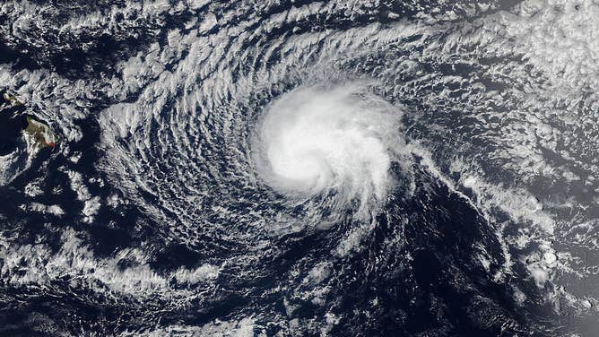
Hurricane Darby weakened into a tropical storm before impacting Hawaii in July 2016.
(NOAA)
The rare, landfalling tropical cyclone produced nearly a foot of rain in higher elevations that caused flash flooding.
According to NHC data, there have only been 16 landfalling tropical cyclones in the Aloha State, many of which took place during or around El Niño weather patterns, when water temperatures are warmer and there are more favorable upper-level winds in parts of the Pacific.
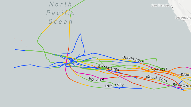
Only 16 tropical cyclones have made landfall in Hawaii in recent memory.
(National Hurricane Center)
There were no reported fatalities on the islands, and most impacts were considered to be minimal.
Meteorologists say warmer-than-average water temperatures in 2016 and periods of reduced upper-level winds likely helped "Darby" stay intact longer and helped keep the system classified as a tropical storm as it impacted the Big Island.
Water temperature departures from average in 2016 shower stretches of the Pacific were warmer than average.
(NOAA)
Eastern Pacific keeps producing
The Eastern Pacific is running ahead of what is considered to be an average season.
Darby is the fourth named storm of the 2022 season. Typically, the fourth named storm doesn’t form until July 15, and that generally is the same date when the season’s second hurricane is christened.
Including Darby, the Eastern Pacific has now seen five named storms and four hurricanes. This apparent busier-than-average year is due in part to Bonnie, which formed in the Atlantic Basin and crossed over into the Eastern Pacific.
Because of Bonnie's crossover, the hurricane season in the Eastern Pacific will be known for having two "B" named storms.
CLICK HERE TO GET THE FOX WEATHER UPDATE PODCAST
The next named storm name will be "Estelle."
The hurricane season in the Eastern Pacific runs through Nov. 30.
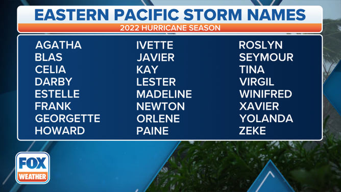
A table showing an alphabetical list of the 2022 Eastern Pacific tropical cyclone names as selected by the World Meteorological Organization. The official Eastern Pacific hurricane season runs from May 15 through Nov. 30.
(FOX Weather)