Flash Flood Warnings cover New York City, flooding subways and streets amid torrential rain slamming Northeast
A potentially life-threatening situation may unfold in the New York City tri-state area as heavy rains lash the already heavily saturated region, which could lead to widespread flash flooding. NOAA's Weather Prediction Center has placed the area under a ‘Moderate’ risk of flash flooding for Friday.
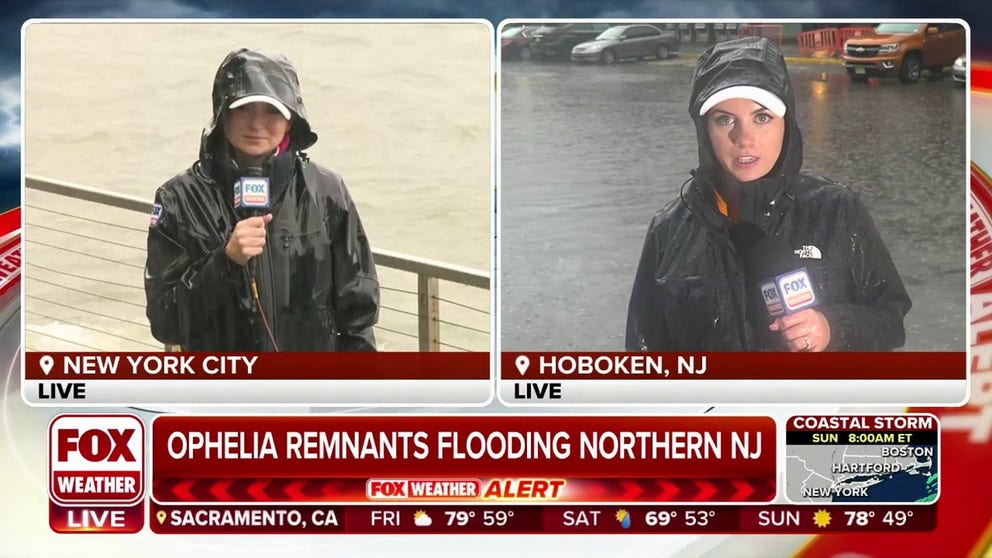
Ophelia's remnants flooding northern New Jersey on Friday morning
A potentially life-threatening situation may unfold in the New York City tri-state area Friday as heavy rains from the remnants of Tropical Storm Ophelia lash the already heavily saturated region, with
As of 9:30 AM on Friday, ‘dangerous and life-threatening’ flooding is underway in New York City from torrential downpours slamming the Northeast. Continuous coverage has moved here.
NEW YORK – A life-threatening situation is unfolding in the New York City tri-state area Friday as heavy rains from the remnants of Tropical Storm Ophelia lash the already heavily saturated region, with "numerous" instances of flash flooding expected across the area.
The entire New York City area was under Flash Flood Warnings on Friday morning as the Big Apple was drenched by several inches of relentless rain, flooding subway stations in Brooklyn and causing massive system-wide disruptions.
"There are major disruptions to subway service, especially in Brooklyn," Metropolitan Transportation Authority said.
Meanwhile, hundreds of miles of coastline from New England to the Southeast are on alert as tidal flooding impacts coastal communities from to combined effects of remnants of Tropical Storm Ophelia and king tides from the final Supermoon of 2023.
Flood Warnings posted for New York City
The remnants of Ophelia, combined with an approaching upper-level disturbance, is bringing heavy rains and triggering a flash flooding threat for millions in the Northeast and New England into the weekend.

(FOX Weather)
The highest threat of flash flooding is focused across most of central and northern New Jersey, the New York City tri-state area, New York’s Hudson Valley and southern Connecticut.
A water rescue was reported in Port-au-peck located within Oceanport in Monmouth County, New Jersey, after a vehicle was submerged in water, according to storm reports.
Flash Flood Warnings are in effect for the New York City area until at least 11:30 a.m. ET. Some areas have already received over 3-5 inches of rain, and the rate of rainfall is expected to continue at up to 2 inches per hour.

(FOX Weather)
"You think about this, and we’ve basically got a couple of different players here coming together," FOX Weather meteorologist Amy Freeze said. "The ghost of Ophelia and the Supermoon join for a complex situation, a one-two punch of saltwater flooding and now the potential for freshwater flooding. And New Jersey appears to be the bulls-eye. But, you can’t discount the five boroughs of New York City, Long Island and even coastal Connecticut."
7 FACTS YOU SHOULD KNOW ABOUT FLASH FLOODS

(FOX Weather)
NOAA's Weather Prediction Center highlighted communities from New Jersey to New York and Connecticut as being under a very likely risk for seeing flooding - a level 3 on their 4-point scale of flash flood risk. The zone includes New York City and more than 20 million residents.

(FOX Weather)
The National Weather Service issued Flood Watches that extend from the New York City tri-state area, including New York’s Hudson Valley, Long Island, most of New Jersey and western Connecticut.
The NWS said excessive rainfall could result in the flooding of rivers and streams across the region, and other low-lying, flood-prone areas are also at risk of becoming inundated by floodwaters.
"The tough thing is the amount of rain that we’re expecting," FOX Weather meteorologist Britta Merwin said. "That part of the forecast continues to increase."

(FOX Weather)
The FOX Forecast Center says there’s now a good chance of 3 to 5 inches of rain with isolated totals of 6-8 inches falling across very populated areas in the Northeast, including New York City, Long Island, southern Connecticut and New Jersey.
Some of the areas that significant flooding in July around West Point and the lower Hudson Valley are also in the bull's-eye for where some the heaviest rain could fall during the next 48 hours.

(FOX Weather)
Millions of people living in the area should make preparations in case Flood Warnings or Flash Flood Emergencies, the most extreme of flood warnings issued by the National Weather Service, are issued.
Be sure to download the free FOX Weather app and enable notification to be sent an alert if warnings are issued in your area.
FLOOD WATCH, WARNING AND EMERGENCY: HERE ARE THE DIFFERENCES THAT COULD SAVE YOUR LIFE
Coastal concerns linger up from Northeast to Southeast

(FOX Weather)
Meanwhile, the FOX Forecast Center says that the onshore flow of winds, in addition to the upcoming Supermoon, is increasing the coastal flood threat in that region.
"On top of what’s falling from the sky, there are coastal concerns," Merwin said. "That’s from water being pushed in by strong winds."
Winds could gust between 40 and 50 mph along the coast, including Atlantic City on the Jersey Shore, and between 20 and 30 mph in New York City, Long Island and coastal areas of New England.
Those wind speeds could lead to power outages due to some trees being brought down.
"So, this is going to feel like a nor’easter in full effect, that’s for sure," Merwin said.
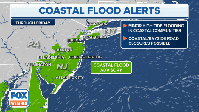
Coastal Flood Alerts in effect in the Northeast and mid-Atlantic.
(FOX Weather)
Coastal flood alerts are in effect along the East Coast from the Northeast to the mid-Atlantic because strong winds will push water onshore. Add to that the final Supermoon of 2023, which will cause higher-than-average high tides, resulting in coastal communities up and down the East Coast experiencing moderate to major flooding.
One of the cities that could see major coastal flooding is Charleston, South Carolina. That city already saw flooding when Tropical Storm Ophelia made landfall in North Carolina last weekend.
The Chesapeake Bay is also at risk of flooding as tides run higher than usual and strong winds push large amounts of water farther inland.
Florida, Southeast coast at risk of coastal flooding due to king tides
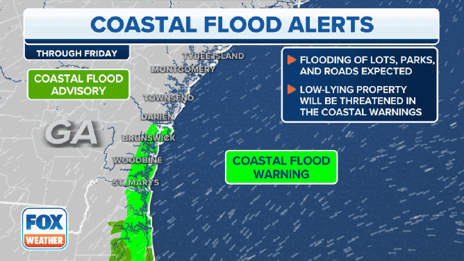
Coastal flood alerts in effect in the Southeast.
(FOX Weather)
Coastal Flood Warnings are also in effect along the coast of southeastern Georgia and northern Florida, including Savannah in Georgia and Jacksonville in Florida.
"A (Coastal Flood) Advisory is for nuisance flooding during high tide. You might have a couple inches of water show up, you can drive through it, but you need to be vigilant," Merwin said. "A Coastal Flood Warning means you could possibly have 1-2 feet of above normally dry ground. That’s talking about the difference between ‘this is annoying, and I’m trying to get to work’ and ‘Holy cow! I have water that’s surrounding my car, and now I’m stuck.’"
The National Weather Service in Jacksonville is warning residents and visitors that roads may be closed in the region because of the flooding potential, and floodwaters may inundate low-lying buildings, including homes, businesses and critical infrastructure.
FLORIDA FACES DUAL THREAT OF RELENTLESS RAINS, COASTAL FLOODING
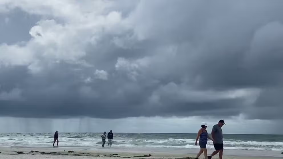
See it: Large rain shaft captured on video in Siesta Key, Florida
A rain shaft was captured on video in Siesta Key, Florida, on Wednesday.
Beach erosion is another concern as relentless waves continue to pound against the shoreline.
A stalled-out cold front is also bringing relentless rain and thunderstorms to the Sunshine State, which is also raising flood concerns due to the high rain totals.