Sudden stratospheric warming, polar vortex disruption could mean colder weather for eastern US
Arctic-air outbreaks followed many of the most recent sudden stratospheric warming events and polar vortex disruptions, but the resulting bitterly cold air happened in different regions on Earth and at different times after the disruptions.

What is the 'polar vortex'?
When a significant snowstorm or cold snap arrives, you may hear it blamed on the "polar vortex."
The polar vortex is getting disrupted as temperatures climb high in the atmosphere above the North Pole, and this could lead to a significant change in weather patterns over the U.S. and Canada as March approaches.
In simplest terms, the polar vortex describes a band of strong winds that circles the North Pole from around 55 degrees north latitude (the latitude of Ketchikan, Alaska) at about 10 to 30 miles above the ground.
Why do those winds matter? Think of a spinning top: As long as the rotation is constant and stable, the top stays spinning in a nearly fixed pattern. When the polar vortex is stable, the spinning winds circling the pole act like a wall that keeps the arctic air bottled up atop the planet.
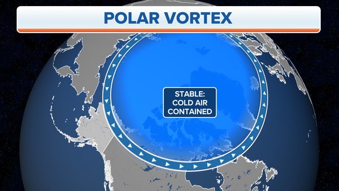
The cold air is contained near the North Pole when the polar vortex is stable.
(FOX Weather)
In that situation, the midlatitude areas, including much of the U.S., will typically avoid bitterly cold conditions.
About every other year, however, weather events in the lower atmosphere will send strong atmospheric waves up into the stratosphere, where they can interact with the polar vortex. The stratosphere is the layer of the atmosphere above the troposphere, which is where we live and where almost all the weather on Earth occurs.
WHAT ARE THE 5 LAYERS OF OUR ATMOSPHERE?
Going back to the analogy, this has the effect of knocking the spinning top off its axis. It loses speed and severely wobbles or even topples over. In the atmosphere, disrupting the polar vortex will cause it to slow down and wobble, allowing the collapse of the protective wall around all that frigid air.
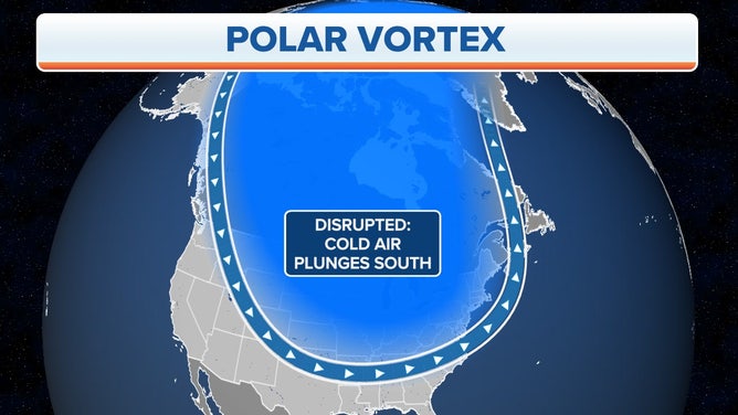
The cold air can plunge south into the midlatitudes of the U.S. when the polar vortex is disrupted.
(FOX Weather)
Now that the protective wall is gone, cold air is able to spill southward into southern Canada and the U.S., and milder air rushes into the polar regions to replace it. This is when you might hear the term "sudden stratospheric warming" start getting tossed around – it's a signal that the polar vortex has been disrupted, and the weather will start changing across the midlatitudes in the days and weeks ahead.
Sudden stratospheric warming event is underway
According to NOAA, temperatures in the stratosphere above the North Pole and Arctic region are rapidly rising due to a sudden stratospheric warming event. This comes after the stratosphere's temperatures in that region reached near-record lows in early January.
The sudden stratospheric warming event was kicked into gear by planetary waves, or disturbances, in both the troposphere and stratosphere, noted polar vortex experts Amy Butler of NOAA’s Chemical Sciences Laboratory and Laura Ciasto of NOAA’s Climate Prediction Center.
A planetary wave in the troposphere at the end of January gave the polar vortex a minor bump from below, which they said caused some rapid but modest warming. That event likely destabilized the polar vortex enough that a weaker disturbance in the stratosphere about a week later triggered a total disruption and sudden stratospheric warming event, Butler and Ciasto explained.
"What the disruption will mean for weather down here in the troposphere is still uncertain, but sometimes these events lead to extreme cold air outbreaks in the mid-latitudes of the United States," NOAA said in a blog post last week.
As a result of the sudden stratospheric warming and coinciding polar vortex disruption, stratospheric temperatures have climbed by about 50 degrees in the past week. NOAA noted that this is the fourth sudden stratospheric warming event in the last six years, which matches the frequency that's been observed over the last six decades of records.
Some guidance from long-range computer forecast models suggests a lobe of this disrupted polar vortex will first shift toward Europe and then continue moving eastward over the next week to 10 days. Other models take things one step further, first displacing the polar vortex and then splitting it into two pieces. Regardless of the polar vortex's configuration, NOAA said it's becoming clear that the polar vortex will not be in its typical form over the next few weeks.
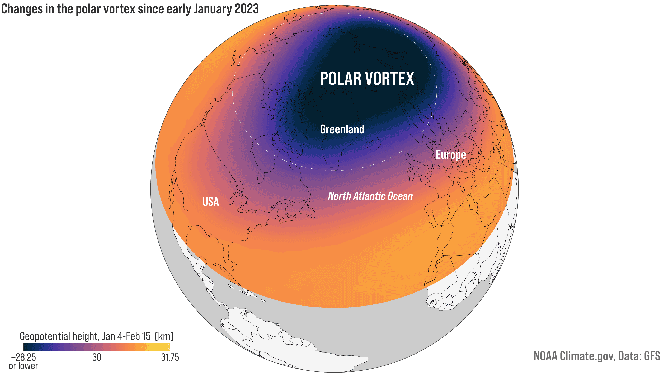
The location and strength of the Northern Hemisphere stratospheric polar vortex on Jan. 4, 11, 18 and 25, and Feb. 1, 8 and 15, 2023. A disruption caused the polar vortex to shift southward from the North Pole toward Europe. Lower heights indicate low pressure (and colder temperatures).
(NOAA Climate.gov animation, based on GFS data from Laura Ciasto)
Sometimes, a disruption of the polar vortex has little impact on the weather. Other times, the impacts may be delayed between two weeks to two months after the polar vortex initially gets disrupted, according to NOAA.
Butler noted that arctic-air outbreaks followed many of the most recent sudden stratospheric warming events and polar vortex disruptions, but the resulting bitterly cold air happened in different regions on Earth and at different times after the disruptions.
IS SPRING COMING EARLY? NOAA PREDICTS LINGER LA NIÑA TO IMPACT WEATHER ACROSS U.S. THROUGH MAY
"A disrupted polar vortex tends to have its strongest tropospheric impact over the North Atlantic, which increases the odds for colder conditions across the eastern United States or northern Eurasia. But it’s not the only influence out there," NOAA said in last week's blog post. "Other phenomena like La Nina, the Madden Julian Oscillation or the chaotic nature of the atmosphere can also affect how our atmosphere reacts to a disruption of the stratospheric polar vortex."
Butler told FOX Weather in an email that the earliest this sudden stratospheric warming event would affect the weather on Earth's surface, based on the latest forecast guidance, is about the first week of March.
"The important thing is this event can't tell us for sure that it's going to get colder and snowier in any given location," she said. "It merely increases the chances of those conditions occurring."