Daily Weather Update from FOX Weather: Millions to roast this weekend as heat dome moves across US
Top weather news for Friday, June 20, 2025: Dangerous heat wave roasts northern tier and central U.S. before moving east this weekend. Meanwhile, nighttime severe weather threat targets Dakotas and Upper Midwest.

Weather in America: June 20, 2025
FOX Weather has you covered with the breaking forecasts and weather news headlines for your Weather in America on Friday, June 20, 2025. Get the latest from FOX Weather Meteorologist Britta Merwin.
Welcome to the Daily Weather Update from FOX Weather. It's Friday, June 20, 2025. Start your day with everything you need to know about today's weather. You can also get a quick briefing of national, regional and local weather whenever you like with the FOX Weather Update podcast.
Heat dome bakes millions across central US before pushing New York, Philadelphia temps toward triple digits
On the first day of astronomical summer, millions of people across the central U.S. and Great Lakes are under heat alerts as a sprawling high pressure system, also known as a heat dome, is forecast to push temperatures in the Northeast toward the triple digits.
According to the FOX Forecast Center, the stout system will move eastward across a large swath of the country. This will bring sweltering heat to major cities from Chicago to Detroit to the major urban centers along the Interstate 95 corridor on the East Coast this weekend.
New York City and Philadelphia will flirt with 100-degree temperatures into early next week, which is rare for June.
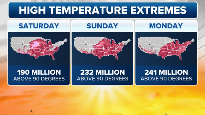
This graphic shows forecast high temperatures beginning Saturday, June 20, 2025.
(FOX Weather)
Northern US faces one-two punch of powerful storms Friday
Thunderstorm alerts were issued Friday morning across Minnesota and parts of Iowa during the first of two rounds of severe weather that are expected to play out across the northern tier of the country Friday.
Storms are packing high winds, heavy rain and lots of lightning, making for a rough morning commute, especially for Minneapolis.
The second round comes Friday evening as more storms develop from Montana into Minnesota. They are expected to continue through the overnight hours, eventually arriving in the Upper Peninsula of Michigan.
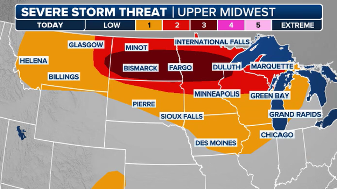
This graphic shows the severe weather threat for Friday, June 20, 2025.
(FOX WEather)
Renewed flooding, mudslides prompt weekslong closure of I-40 at Tennessee-North Carolina border
Road crews are hard at work along the Tennessee and North Carolina border to remove debris on Interstate 40 after heavy rain caused flash flooding and mudslides on Wednesday evening, months after Hurricane Helene did the same.
The Tennessee Department of Transportation said I-40 will likely be closed for at least two weeks during the cleanup.

Work underway to repair I-40 at Tennessee/North Carolina border after flash flooding
Heavy rainfall triggered flash flooding and mudslides Wednesday evening, wiping out a portion of Interstate 40 at the Tennessee/North Carolina line.
Watch: Dusty tornado spins across road in front of FOX Weather storm tracker
Storm trackers got a wild ride on their journey through the Canadian prairies Thursday when a massive and dusty tornado dropped down in front of their cars.
FOX Weather Storm Tracker Brandon Copic was chasing storms in western Manitoba and eastern Saskatchewan when the twister formed along remote farmland near the Saskatchewan town of Alameda.

Dusty tornado spins across road in front of FOX Weather storm tracker
FOX Weather storm tracker Brandon Copic was chasing storms in western Manitoba and eastern Saskatchewan when the twister formed along remote farmland near the Saskatchewan town of Alameda.
Are you a weather wiz?
Put your weather trivia knowledge to the test with our five-question quiz. Click here to get started.

(FOX Weather)
Before you go
Here are a few more stories you might find interesting:
- New York City, Washington slammed by thunderstorms as severe weather knocks out power to over 600,000
- Is the Atlantic hurricane season about to explode or continue to fizzle?
- Watch: SpaceX Starship explodes due to ‘major anomaly’ during test at Texas base
Need more weather? Check your local forecast plus 3D radar in the FOX Weather app. You can also watch FOX Weather wherever you go using the FOX Weather app, at foxweather.com/live or on your favorite streaming service.
It’s easy to share your weather photos and videos with us. Email them to weather@fox.com or add the hashtag #FOXWeather to your post on your favorite social media platform.