New York City, Washington slammed by thunderstorms as severe weather knocks out power to over 600,000
Severe Thunderstorm Watches spanned several states across the mid-Atlantic and Northeast, lasting until late Thursday evening, with possible threats of damaging wind gusts of greater than 60 mph and large hail up to 1 inch in diameter.

Lightning strike injures visitor in New York’s Central Park
Thunderstorms moved across the Tri-State area on Thursday afternoon producing lightning that injured a young person in Central Park, according to authorities.
WASHINGTON – Rounds of severe thunderstorms slammed the Interstate 95 corridor on Thursday, with heavy rains, damaging wind gusts and frequent lightning reported across the Washington, Philadelphia, and New York City areas, leaving over 600,000 without power.
Severe Thunderstorm Watches spanned several states across the mid-Atlantic and Northeast, lasting until late Thursday evening, with possible threats of damaging wind gusts of greater than 60 mph and large hail up to 1 inch in diameter.

Warning boxes are color coded as: Severe Thunderstorm Warnings in yellow, Tornado Warnings in red, Tornado Warnings with confirmed tornado in purple, Flash Flood Warnings in green, and Flash Flood Emergencies in pink.
(FOX Weather)
During the height of the activity, about 300,000 power outages were reported in Pennsylvania, with nearly a quarter million in Virginia and another 100,000 in Maryland, according to FindEnergy.com.

Tree limb falls on power lines as thunderstorms strike DC area
Footage shows a tree limb falling onto power lines in Silver Spring, Maryland, late Thursday afternoon.
In New York City, a teen in Central Park was reported to be injured by a nearby lightning strike and transported to a local medical center.
While further south in Washington, D.C. firefighters attended to a partial construction job site collapse due to gusty winds - there were no reported significant injuries during the event.

Ferocious winds cause damage to building in Washington, D.C.
Wind gusts over 65 mph swept through the nation's capital Thursday evening, causing damage to an unoccupied building.
In Bethesda, Maryland, a truck was scorched after a falling tree knocked a power pole into the truck.
"It was a big fire," a witness told FOX 5 DC's Bob Barnard. "So the tree came down, took the electrical out, brought this pole down on top of this truck, started an electrical fire in the truck and then all the combustible materials within the truck caught on fire."
Witnesses said no one was in the truck when the power lines gave way.
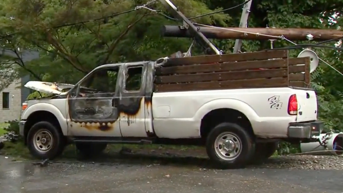
Truck catches fire after storms topple trees and power lines in Bethesda, Maryland.
(FOX 5 DC)
Gusts reached 66 mph at Washington's Dulles International Airport, while Regan National Airport clocked a gust of 61 mph.
Thunderstorms also caused delays in air travel around the Northeast. New York's JFK International Airport and LaGuardia Airport, Newark Liberty International Airport, and Philadelphia International Airport all issued ground delays, which lasted several hours.
FlightAware reported more than 9,000 flights were either delayed or canceled on Thursday across the country, with weather impacting many of the scheduled routes.

Thunder cracks in New York City as storms move into the Northeast
Thunderstorms rolled through New York City and Jersey City on Thursday afternoon, the opening salvo as the region remains under threat of renewed severe weather into the night.
TORNADO DAMAGE SEEN IN OHIO VALLEY AS DERECHO KNOCK OUT POWER TO NEARLY HALF A MILLION
The storm activity is being driven by a low-pressure system moving out of the Midwest, Great Lakes and Ohio Valley where a derecho left a trail of destruction Wednesday.
According to the FOX Forecast Center, a serial derecho ripped across the Ohio Valley across a 580-mile stretch from Illinois to western Pennsylvania.
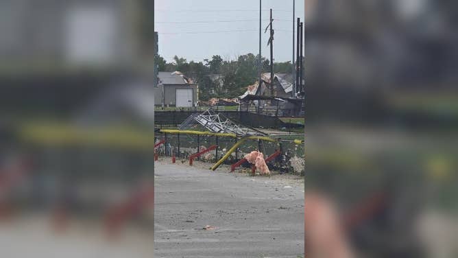
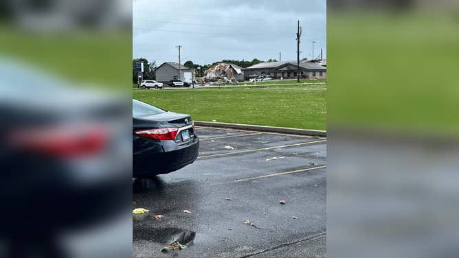
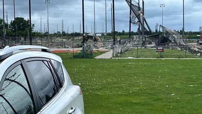
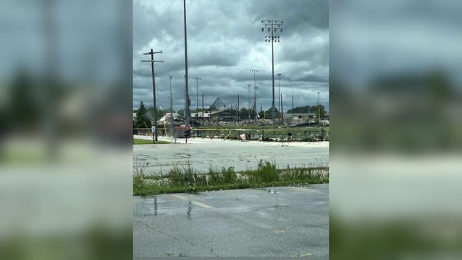
![Damage reported in Jacksonville, Illinois to the Future Champions Sports Complex.]() Image 1 of 7
Image 1 of 7Damage reported in Jacksonville, Illinois to the Future Champions Sports Complex. (Laura Wamble via Facebook)
![Damage reported in Jacksonville, Illinois to the Future Champions Sports Complex.]() Image 2 of 7
Image 2 of 7Damage reported in Jacksonville, Illinois to the Future Champions Sports Complex. (Laura Wamble via Facebook)
![Damage reported in Jacksonville, Illinois to the Future Champions Sports Complex.]() Image 3 of 7
Image 3 of 7Damage reported in Jacksonville, Illinois to the Future Champions Sports Complex. (Laura Wamble via Facebook)
![Damage reported in Jacksonville, Illinois to the Future Champions Sports Complex.]() Image 4 of 7
Image 4 of 7Damage reported in Jacksonville, Illinois to the Future Champions Sports Complex. (Laura Wamble via Facebook)
![Collapse of an unoccupied building under renovations in Washington, D.C.]() Image 5 of 7
Image 5 of 7Collapse of an unoccupied building under renovations in Washington, D.C. (DC Fire and EMS Department)
![Collapse of an unoccupied building under renovations in Washington, D.C.]() Image 6 of 7
Image 6 of 7Collapse of an unoccupied building under renovations in Washington, D.C. (DC Fire and EMS Department)
![Collapse of an unoccupied building under renovations in Washington, D.C.]() Image 7 of 7
Image 7 of 7Collapse of an unoccupied building under renovations in Washington, D.C. (DC Fire and EMS Department)


The windstorm produced reports of tornadoes in Missouri, Illinois, and Michigan.
A 71-mph wind gust that brought down powerlines was recorded in Owen, Indiana on Wednesday night.