Dangerous storms bring tornadoes, damaging wind, hail to northern US
Strong thunderstorms forecast to continue through the overnight hours, eventually arriving in the Upper Peninsula of Michigan.

Intense storms to race across Northern Tier, Upper Midwest on Friday
Intense thunderstorms are possible across the Dakotas, Minnesota, northern Wisconsin and Michigan's Upper Peninsula beginning Friday afternoon through Friday evening as storms fire along the upper ridge of an area of high-pressure.
MINNEAPOLIS – Intense thunderstorms rolled across the Dakotas and Minnesota to start the weekend, as storms fired along the upper ridge of an area of high-pressure.
Bismarck and Fargo, the largest cities in North Dakota, are among the places inside a Level 3 out of 5 risk zone highlighted by NOAA’s Storm Prediction Center.
Minneapolis was included in the Level 2 zone that stretched from Montana into Michigan.
TORNADO DAMAGE SEEN IN OHIO VALLEY AS DERECHO KNOCKS OUT POWER TO NEARLY HALF A MILLION

(FOX Weather)
At least one stovepipe tornado was observed near Eckelson, North Dakota on Friday evening.
The supercell stayed north of Interstate 94, but some damage was reported by storm chasers.
Data from FindEnergy.com indicated that there were nearly 10,000 power outages, with issues reported between Bismark and Jamestown.
THE SPC 5-POINT SEVERE THUNDERSTORM RISK CATEGORY SCALE EXPLAINED
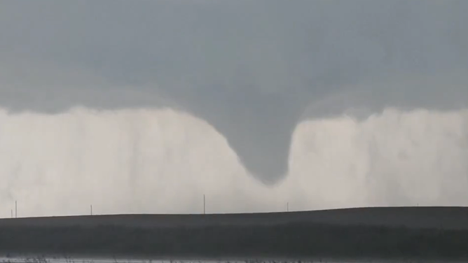
Stovepipe tornado near Eckelson, North Dakota on Friday evening.
(CoreyGerkenWX / FOX Weather)
All modes of severe weather are possible with any severe storms that form. However, the primary concerns will be damaging winds and large hail. The FOX Forecast Center noted that hurricane-force wind gusts, winds more than 74 mph, could be possible.
The storms are riding around the edge of a sprawling area of high pressure that is behind a heat dome moving across the U.S. through the weekend.
POWERFUL STORMS RACE ACROSS PLAINS WITH HURRICANE-FORCE WIND GUSTS, BASEBALL-SIZED HAIL

(FOX Weather)