Cross-country storm to pack threats of severe storms, flash flooding, heavy snow through late-week
While heavy snow is likely in parts of the Rockies and Plains on the cold side of the storm, severe storms are expected Thursday and Friday from Texas to the central Gulf Coast.
Potential for severe weather in the South as cross-country storm moves east
Severe storms and a risk for flooding will be possible for parts of the South on Thursday. The greatest risk for severe storms will be Thursday along the I-35 corridor in Oklahoma and Texas. Tornadoes, hail and 60 mph wind gusts are possible.
The FOX Forecast Center is tracking the next cross-country storm expected to impact most of the U.S. through late-week, packing threats of severe weather, flooding rain and heavy snow.
"We're starting the week off with a huge nor'easter on the East Coast. Then, for the West Coast, a significant atmospheric river event," FOX Weather meteorologist Britta Merwin said. "As we work our way to the end of the workweek, this atmospheric river event is going to turn into a big storm that's going to produce some rain. And, yes, severe weather."

(FOX Weather)
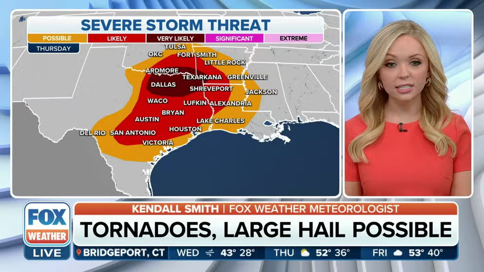
Southern severe storms expected Thursday
On the warm side of the cross-country storm, severe thunderstorms will be possible along parts of the Interstate 35 corridor in Oklahoma and Texas and eastward into southwestern Arkansas and northwestern Louisiana.
NOAA's Storm Prediction Center has increased the severe storm threat to a level 3 on the 5-point risk scale, depicted as "very likely" on the map below.
According to the FOX Forecast Center, computer forecast models suggest supercells will be possible along a dryline, which will be capable of producing tornadoes, large hail and damaging winds. The severe weather threat could continue Thursday night and into early Friday morning.

(FOX Weather)
Severe weather threat shifts east Friday
Isolated to scattered severe thunderstorms will remain possible Friday across parts of the central Gulf Coast states. The main threat appears to be damaging wind gusts, but a tornado or two is also possible.
The FOX Forecast Center said a line of thunderstorms will likely slide eastward on Friday along or just ahead of a cold front from coastal Texas into Louisiana and southern and central Mississippi. An isolated threat for damaging winds may persist into Friday evening across parts of southwestern Georgia and the Florida Panhandle.

(FOX Weather)
How much rain will fall?
A flood threat will also be present, especially on Thursday and Friday, focused on the Ark-La-Tex region, where already-saturated soils from recent rains could lead to an increased threat of flooding. This region is currently 8-plus inches above average in terms of year-to-date rainfall.
NOAA's Weather Prediction Center has placed portions of East Texas and the lower Mississippi Valley under a slight risk (level 2 out of 4) of flash flooding on Thursday.
Between 1 and 2 inches of rain is expected across a broad area from East Texas to parts of Florida and Georgia. Localized areas could see up to 3 inches of rainfall.
HOW HEAVY IS IT REALLY GOING TO RAIN?

(FOX Weather)
Heavy snow possible for Rockies, Plains
On the cold side of the cross-country storm, heavy snow is likely in parts of the Rockies and Plains.
"The majority of this storm is going to be rain with exceptions of very far north locations," Merwin said. "Minneapolis, Detroit and Green Bay, we'll watch you for the potential here of crossing over to snow."
The FOX Forecast Center said while the highest totals will be found in the high country, Denver could end up with 1 to 3 inches of powdery snow between Wednesday and Thursday.
HOW COLD DOES IT HAVE TO BE TO SNOW?

(FOX Weather)
As the storm system shifts east into the Plains on Thursday, a stripe of snow is expected from Nebraska into Wisconsin and western and northern Michigan.
In that region, snowfall totals will likely increase from south to north, which means the highest totals can be expected in the Arrowhead of Minnesota, northern Wisconsin and the Upper Peninsula of Michigan, the FOX Forecast Center said.

(FOX Weather)
Even with the heaviest snow farther north, some travel impacts are still likely for Minneapolis-St. Paul, where a few inches of snow could fall. Minneapolis is currently at its eighth-snowiest winter on record with 80.3 inches so far, less than 20 inches shy of the record 1983-84 season when 98.6 inches fell.
THESE ARE THE 7 SNOWIEST CITIES IN THE US

(FOX Weather)