Bryan Norcross: Tropical Storm Harold coming ashore in Texas while Franklin moves on the northern Caribbean
In the Caribbean, Tropical Storm Franklin is drifting around, struggling under hostile upper winds. The environment is forecast to become a bit more conducive for strengthening as the storm moves north toward the Dominican Republic and Haiti later today and tomorrow.

FOX Weather is your Hurricane HQ, streaming free 24/7.
(FOX Weather / FOX Weather)
Updated at 9 a.m. ET on Tuesday
The Gulf system was named a tropical storm overnight, just as forecast yesterday. Now, Tropical Storm Harold is moving into South Texas. Wind gusts over 50 to 60 mph are likely right along the coast north of where the center comes ashore.
Several inches of rain could cause some local flooding, though the rain is welcome if it doesn’t come all at once. The extra-dry ground will soak up the rain pretty well, except in super-heavy downpours. Some flash flooding is likely in the Mexican mountains just south of the border. Up to 10 inches of rain is forecast there. Houston and Austin will miss most of the rain. San Antonio will get some, especially south of the city.
Harold will move inland and die out by tomorrow, and unfortunately, the hot, dry weather will return.
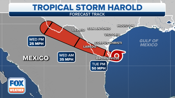
The forecast track of Tropical Storm Harold on Tuesday, August 22, 2023.
(FOX Weather)
In the Caribbean, Tropical Storm Franklin is drifting around, struggling under hostile upper winds. The environment is forecast to become a bit more conducive for strengthening as the storm moves north toward the Dominican Republic and Haiti later today and tomorrow.
The current thinking is that it will cross the mountainous island as a tropical storm but will carry a boatload of tropical moisture. The moisture interacting with the mountains will cause life-threatening torrential rain. Mudslides and flash flooding are likely in Haiti and the Dominican Republic.
Generally, 5 to 10 inches of rain with some places receiving 15 inches is the forecast for Haiti and the Dominican Republic. Across the southern side of Puerto Rico, the forecast is for an additional 1 to 3 inches with 6 inches in some locations.
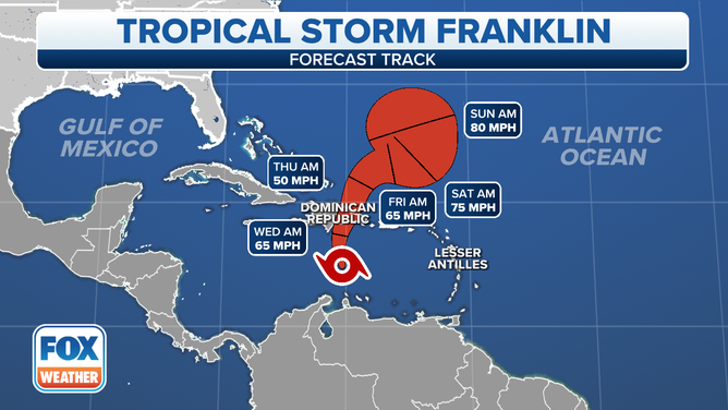
The forecast track for Tropical Storm Franklin on Tuesday, August 22, 2023.
Everything about the forecast for Franklin is highly uncertain, especially what happens after it is in the Atlantic north of the islands on Thursday. The steering currents will be very weak, and the path the storm takes is related to how strong it is after it passes over the tall mountains. There are too many variables to pin down exactly what will happen, but the consensus of the computer forecasts is that the storm will eventually recover, strengthen into a hurricane, and move generally north. The National Hurricane Center forecast reflects that idea.
We’ll watch in case it threatens Bermuda or someplace farther north.
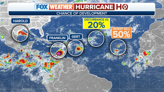
An overview of the tropical Atlantic Ocean on Tuesday, August 22, 2023.
The systems in the Atlantic east of the Caribbean islands are not a threat to land, so no concerns there.
Despite the explosion of named storms over the past several days, the tropical Atlantic continues to be generally hostile to storms getting very strong. It only takes one storm to find a patch of atmosphere that is conducive for development for one week to ruin the season, of course. But for now, things look good even with the extra-warm ocean water.