Bryan Norcross: Possible development off the Southeast coast
Scientists at Colorado State University, where seasonal forecasts were pioneered 40 years ago, aren't backing down on their forecast of an extremely busy hurricane season.

FOX Weather is your Hurricane HQ, streaming free 24/7.
(FOX Weather)
Updated at 11 a.m. ET on Tuesday, June 11, 2024
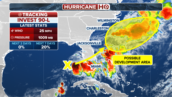
Computer forecast models have been showing a weak low-pressure system forming offshore of the Carolinas in a few days. The National Hurricane Center is giving it a slight chance of developing into at least a tropical depression. The system's official name is Invest 90L. The upper-level winds are not conducive for fast or significant tropical development. In any case, it wouldn't be a threat to the U.S. East Coast
Otherwise, things remain quiet across the tropics, though the macro conditions appear conducive for storms to develop.
The National Hurricane Center is monitoring a disturbance in the Gulf of Mexico for potential tropical development after it crosses Florida and emerges over the southwestern Atlantic.
(FOX Weather)
Scientists at Colorado State University, where seasonal forecasts were pioneered 40 years ago, aren't backing down on their forecast of an extremely busy hurricane season. The update released today continues to call for 23 named storms and 11 hurricanes, with 5 of them reaching Category 3 or above. The CSU forecast matches the consensus of the various forecasting agencies around the world.
The tropical Atlantic, the Caribbean Sea and the Gulf of Mexico are extremely warm. The heat content of the Caribbean water is already as high as we normally see it in September. This extra energy should turn more tropical storms into hurricanes and boost Category 1s into more intense storms. That's assuming the atmospheric pattern over the tropics is conducive to development, of course.

2024 Atlantic hurricane season outlook from Colorado State University compared to the average and the 2022 season.
(FOX Weather)
In the Pacific, the transition to a La Niña is well underway, as forecast. A La Niña is a key factor in creating an upper-level wind regime over the Atlantic that's supportive for storm development.
Statistically, these macro factors have the biggest effect on the number of storms that develop during the hurricane season, but the daily weather pattern comes into play as well. So far, the weather pattern has not switched into typical tropical-season mode in the U.S. The northwestern Caribbean has been drenched with tropical rains, but until today, they haven't been able to move north.
A bubble of high pressure over the Gulf of Mexico has been limiting the rainfall in Florida by holding the tropical weather south. A dip in the jet stream dropping into the Gulf is already pushing the high out of the way, however, and is drawing tropical moisture out of the Caribbean and over South Florida.
Between the jet stream dip and the large high-pressure area in the Atlantic, a persistent atmospheric river of extremely moist tropical air is forecast to aim at Florida this week. The current forecast is for the heaviest rain to fall over the southern half of the Florida Peninsula. Next week, the moisture shifts toward the northern and northwestern Gulf coast.
A pocket of atmosphere conducive to tropical development is forecast to develop in the western Gulf next week. Long-range computer forecasts indicate a chance of tropical development, but it's too far out for any certainty. But now that the door to the Caribbean appears to be opening, we'll watch for development farther south, as well as in the Gulf of Mexico.
There is nothing significant to watch for now except for the increasing likelihood of persistent heavy rain arcing across the Florida Peninsula from the Caribbean and Gulf. Stay alert for flood alerts issued for your local area, especially later this week. The southern peninsula is in a drought condition, so initially, the ground will absorb the water, but that might not be the case after a day or two of downpours.