

Bryan Norcross: Isaias's threat zone heads north while Rachel brings a flood threat to the West
FOX Weather Hurricane Specialist Bryan Norcross gives us the latest on Isaias as its remnants head north, as well as Post-Tropical Cyclone Rachel and its impact on the West Coast.
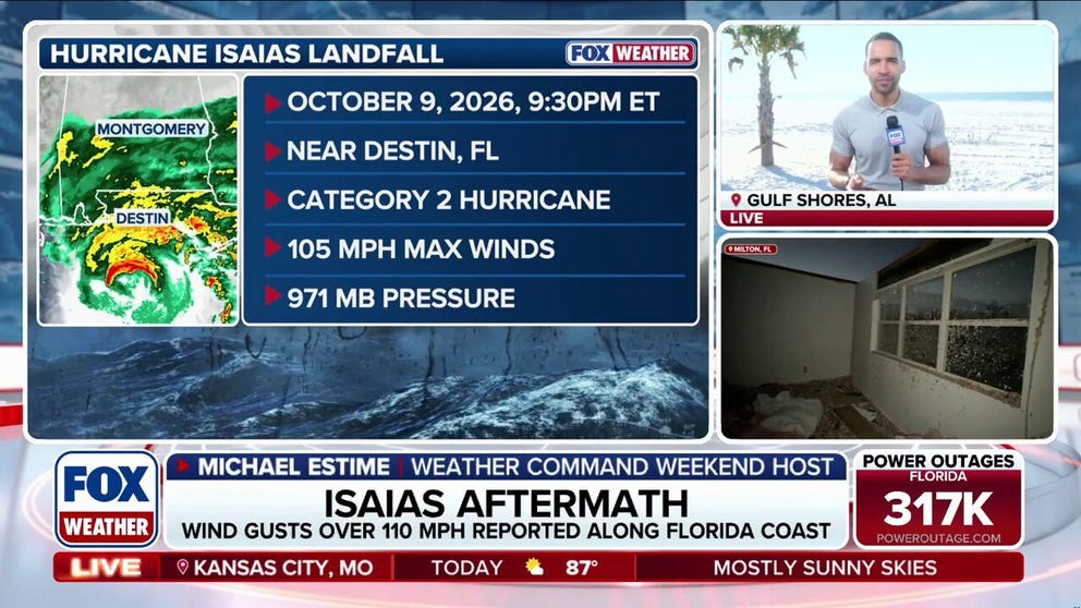
The deadly aftermath of Hurricane Isaias in Alabama and Florida
🌀 🌪️ AFTERMATH: FOX Weather Meteorologist Michael Estime reports from Gulf Shores, Alabama, where residents are left to pick up the pieces after Hurricane Isaias made landfall near Destin, Florida. The deadly Category 2 storm caused significant impacts, including widespread power outages.
This story was last updated at 10:30 a.m. on Sunday, Oct. 11, 2026.
THE REMNANTS OF ISAIAS
The remnants of Hurricane Isaias are spreading toward the Northeast. The remaining threat zone for flash flooding extends from the mountains of eastern Kentucky and West Virginia to Philadelphia and New York City. Generally, 1 to 3 inches of rain is forecast with some areas receiving 5 inches, which is enough to produce dangerous flash flooding.
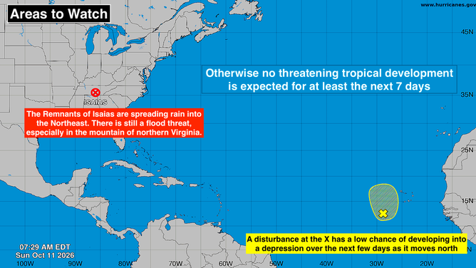
Tropical activity in the Atlantic basin.
(Bryan Norcross / FOX Weather)
Gusty winds, strong enough to knock out power, are still possible in the southern Appalachians closer to the center of the remnant storm.
Dangerous surf conditions will continue on many Gulf and Atlantic beaches. It's still warm from Texas to Florida, so use caution in the water.
THE LATEST FROM FOX WEATHER HURRICANE SPECIALIST BRYAN NORCROSS
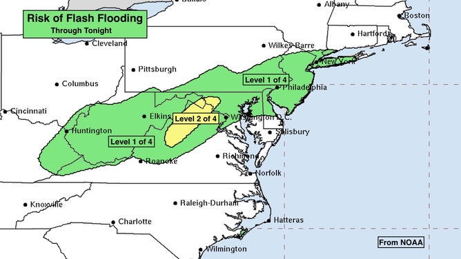
Rain threat due to Isaias on the East Coast.
(FOX Weather)
IN THE FAR EASTERN ATLANTIC
A tropical disturbance that moved off Africa has momentarily found a pocket where the hostile band of El Niño-driven upper winds is not prohibiting development. The National Hurricane Center has the odds of a tropical depression forming in the low range. The disturbance only has two or three days to get organized before the atmospheric environment makes further development impossible.
The system might affect the Cabo Verde Islands, but otherwise no land is threatened.
ELSEWHERE IN THE ATLANTIC
Except for the possibility of a short-lived system in the far eastern Atlantic, no tropical development is expected for at least the next week.
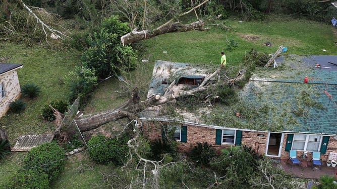
In an aerial view, a worker with Southern Land Services removes a tree that landed on a home when Hurricane Isaias passed through the area on October 10, 2026, in Milton, Florida.
(oe Raedle/Getty Images / Getty Images)
People are asking if, as a practical matter, hurricane season is over. It's possible, but another system like Isaias can't be ruled out. The Gulf is still plenty warm, and the development-prohibiting jet stream could still temporarily move out of the way. So we will continue to watch the Gulf and the warm waters east of Florida for a while longer.
WHAT'S THE DIFFERENCE BETWEEN A HURRICANE MAKING A DIRECT HIT AND LANDFALL?
IN CALIFORNIA AND THE SOUTHWEST
The remnants of Tropical Storm Rachel combined with a strong upper-level system are drenching extreme Southern California with rain stretching from the coastal cities across the deserts into the Intermountain West.
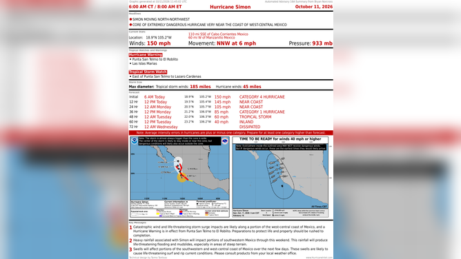
The latest on Hurricane Simon.
(Bryan Norcross)
Heavy rain is likely in San Diego and southern Orange County today with significant, but lower totals as far north as Ventura County and San Bernardino County. Measurable rain will fall across the deserts from Palm Springs to Death Valley to Las Vegas and beyond.
EYE OF THE SEASON: THE MOST NOTABLE ATLANTIC HURRICANES DURING EL NIÑO YEARS
The bullseye for flash flooding over the next few days appears to be north of Las Vegas into southwestern Colorado, but everybody in a large area of the West, where the mountains will enhance the unusual tropical rain, should stay aware and well-informed of flood alerts for their area.
HURRICANE SIMON AND MEXICO
Category 4 Hurricane Simon will come near or over the coast of Mexico just south of Puerto Vallarta. Rainfall near the coast will be enhanced by the mountains. Flash flooding and mudslides are possible.
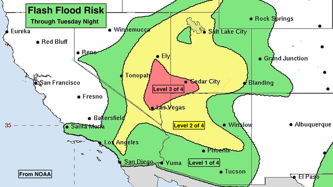
Flood threat in the West.
(Bryan Norcross)
The storm should weaken a bit as it brushes the coast, but significant impacts are still expected. Everyone near the path of Simon should plan to be in a safe place and away from the ocean.
THE NEXT PACIFIC STORM
South of Mexico, another disturbance has a high chance of developing. This storm will be named Trudy. The consensus of the computer forecast is that it will remain offshore of the Mexican coast for at least the next week.