Odds tick upward for development of tropical wave in central Atlantic
The next named storm in the Atlantic Basin will be Jerry, followed by Karen and Lorenzo. The Atlantic hurricane season runs until Nov. 30.
Odds increase for tropical wave to become a tropical depression in Atlantic next week
The NHC says a tropical wave that just emerged off Africa will find better conditions for development this week and has a "medium" chance of reaching at least tropical depression strength by the end of the week.
MIAMI – We may be entering the final weeks of the 2025 Atlantic hurricane season, but tropical activity is still possible as the National Hurricane Center (NHC) monitors a new area for possible development.
The NHC highlighted an area off the coast of Africa and stretching to the Caribbean where tropical development is possible over the next week. However, forecasters caution that there are conflicting signals on whether the disturbance in the area will ever become organized.

(FOX Weather)
The tropical wave left the coast of Africa and has begun its journey traversing the Atlantic that will last the next several days.
The Hurricane Center said Friday that development was also dependent on how this wave interacts with another tropical disturbance in the eastern tropical Atlantic.
Due to how much organization the tropical disturbance will need, quick intensification is not expected over the next week, despite warm sea-surface temperatures.
So far, the NHC is giving this system a medium chance a tropical depression could form near or east of the Lesser Antilles by the middle or end of next week.
WHAT TO EXPECT FOR FINAL 2 MONTHS OF ATLANTIC HURRICANE SEASON

(FOX Weather)
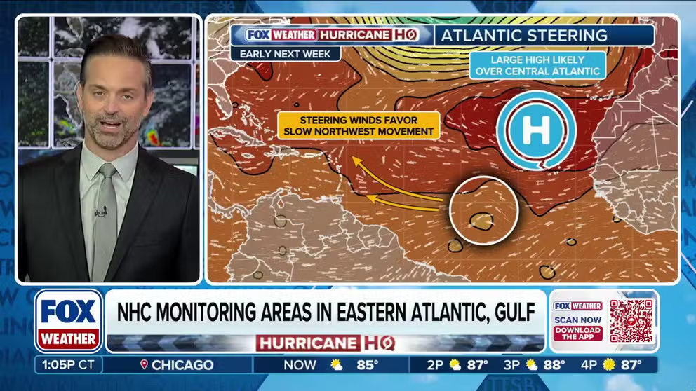
The FOX Forecast Center said it will likely be toward the end of the second week of October when the wave approaches a "fork in the road," determining whether it develops into a storm or fades into disorganized showers.
Computer models remain split on whether the next named storm on the 2025 list, "Jerry," will form out of the broad complex of thunderstorms.
The Global Forecast System, otherwise known as the GFS, continues to show the tropical wave organizing into a tropical depression or tropical storm just east of the Caribbean islands. Meanwhile, the European Centre for Medium-Range Weather Forecasts, which is commonly referred to as the Euro, keeps the system weak and disorganized throughout its lifespan.
The Euro solution would not lead to the formation of a tropical depression or storm and would instead produce only periods of increased cloud cover and scattered showers across the Caribbean islands.
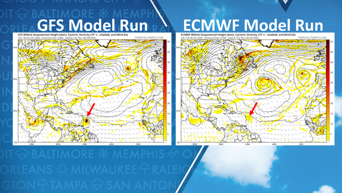
GFS vs ECMWF for Oct. 9, 2025.
(TropicalTidbits.com / FOX Weather)
It is common for major forecast models to display wide differences during the infancy of a tropical system. Over the next several days, forecasters expect the models to gradually converge on a more consistent solution.
A system that tracks closer to the equator has a greater chance of moving farther west across the Atlantic, compared with a system that forms at 20 degrees latitude or farther north.
During October and November, a plethora of troughs and cold fronts frequently sweep across the Atlantic, which can easily recurve tropical cyclones harmlessly into the open ocean.
Systems that remain farther south, however, may pose more of a concern for the Caribbean and other landmasses.
It is also important to note that the recent U.S. government shutdown has not impacted the accuracy of models such as the GFS. Essential staff, including Hurricane Hunters and satellite analysts, continue to perform their duties without interruption.
HURRICANE HUNTERS FLY INTO WORLD’S WORST WEATHER SEE WHICH STORM WAS THE BUMPIEST
Areas to watch for development near Florida, Gulf Coast deemed no tropical threat

(FOX Weather)
Meanwhile, the NHC says two areas of low pressure budding in waters near the U.S. are no tropical threat.
The NHC said a weak area of low pressure near the northwestern Bahamas was still producing just disorganized showers and thunderstorms Saturday. And while the system is expected to drift toward southern Florida over the next couple of days, strong upper-level winds will keep the system from developing into a tropical cyclone.
However, the system will bring heavy rains that could trigger spots of flash flooding along the eastern Florida coast and Bahamas during the next few days.
The NHC also noted another weak area of low pressure off the Gulf Coast that too is now producing disorganized showers and thunderstorms.
"This system is expected to move slowly northwestward during the next day or two, reaching the coast of Texas by Monday," the NHC said. But as like the system near Florida, strong upper-level winds will keep the system from developing tropical cyclone characteristics.
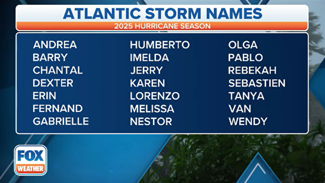
2025 Atlantic hurricane season names.
(FOX Weather)
The Atlantic hurricane season officially runs through Nov. 30, and on average, October and November yield about four named storms, with two of those typically reaching hurricane strength and one intensifying into a major hurricane.