Another multiday severe weather threat looms for storm-fatigued South
Damaging winds, large hail and tornadoes are all possible with this next round of severe storms
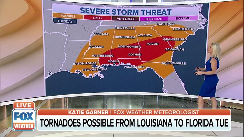
Severe weather takes aim at the Gulf Coast starting Tuesday
Another multiday severe weather outbreak is expected across the South this week and will affect the Gulf Coast starting Tuesday.
The South has been on the receiving end of multiday severe weather outbreaks over the past two weeks, and it looks like that will continue again this week.
April, May and June are typically the three most active months for tornadoes, so it's not uncommon for severe weather to begin ramping up this time of year.
WE'RE ENTERING AMERICA'S MOST ACTIVE TIME OF YEAR FOR TORNADOES
This week's threat will kick off Sunday in the South.
To start the workweek, an area of low pressure develops over the Southern Plains and warm, humid air from the Gulf of Mexico is pulled northward out ahead of it.

(FOX Weather)
Additionally, a stalled cold front is forecast to extend from northwestern Texas to the lower Ohio Valley on Monday, which will provide the triggering mechanism necessary for the development of thunderstorms.
While uncertainty exists in the northward extent of the potential for severe storms, it is very likely that severe storms will be present from North Texas to south-central Mississippi.
Damaging winds, large hail and tornadoes are all possible with this round of storms.
HOW TO WATCH FOX WEATHER ON TV

(FOX Weather)
As the low-pressure system continues to track eastward across the South on Tuesday, the severe weather threat will accompany it in parts of the lower Mississippi Valley, the central Gulf Coast, and the Southeast.
Tuesday's severe thunderstorms might be more isolated in nature due to clouds and widespread rainfall hampering the instability in this region. Still, the highest risk of a severe storm will be centered in areas that stretch from Mississippi, Alabama and the western Florida Panhandle into central Georgia and southwestern South Carolina.
Damaging wind gusts are the primary concern in these areas.
HERE'S WHERE TORNADOES ARE MOST LIKELY TO OCCUR IN EACH MONTH

(FOX Weather)
A strong cold front will be advancing eastward across the southeastern U.S. by Wednesday, setting the stage for another day of severe weather.
Severe storms are most likely to develop in the Tennessee Valley and the southern Appalachians, including parts of eastern Mississippi, Alabama, western and northern Georgia, southeastern Tennessee and southwestern North Carolina.
On Wednesday, damaging winds are again the main threat as the thunderstorms could congeal into a squall line.
WHAT IS A SQUALL LINE AND WHY IS THIS TYPE OF SEVERE WEATHER SO DANGEROUS?

(FOX Weather)
Some severe storms could linger on Thursday in portions of the Carolinas and mid-Atlantic, but the magnitude of this threat remains uncertain since it's still several days away.
If you live in any of these areas at risk for severe thunderstorms next week, now is a good time to freshen up your severe weather safety plan. Click here for a list of tips to guide you in the preparations.
Check back with FOX Weather for updates in the days ahead.