Another April blizzard will bring heavy snow, high winds to Northern Plains this weekend
Power outages, tree damage and very difficult to impossible travel are all expected in the region
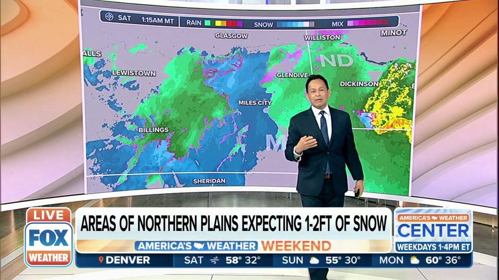
Areas of Northern Plains expecting 1-2 feet of snow
For the second week in a row, an impactful winter storm will blast the Northern Rockies and North Dakota with heavy snow and strong winds. A powerful low pressure will move out of the Rockies and into the Northern Plains on Saturday with the snow continuing into Sunday.
A powerful April storm system is expected to become another blizzard this weekend as it impacts the Northern Plains, including some of the same areas hit hard by last week's historic blizzard in parts of North Dakota and Montana.
The jet stream will take a sharp, southward plunge over the western U.S. and charge eastward into the Plains states, where an area of low pressure has developed on Friday.
This low-pressure system will strengthen over the weekend as it pulls in colder air from the Canadian Prairies on its northern side and warm, humid air from the Gulf of Mexico on its southern side.
HOW TO WATCH FOX WEATHER ON TV

When this type of weather pattern occurs in the spring, it typically results in a sprawling storm with both heavy snow and severe thunderstorms – just like we saw last week when a blizzard buried parts of Montana and North Dakota under 3 to 4 feet of snow and more than five-dozen tornadoes hit the Plains, Midwest and South.
‘ALL WE CAN DO IS PRAY’: PRIZED HORSES BURIED IN SNOW DURING NORTH DAKOTA'S HISTORIC BLIZZARD
The National Weather Service has issued Blizzard Warnings from eastern Montana to northeastern Wyoming, western North Dakota and northwestern South Dakota. Winter Storm Warnings and Winter Weather Advisories are also in effect for other parts of the Northern Plains.

(FOX Weather)
A quick changeover from rain to snow will commence across parts of northeastern Wyoming and eastern Montana into Saturday morning. Heavy snow will then expand into the western Dakotas by the afternoon.
Gusty winds as high as 75 mph will overlap with the heavy snowfall to create blowing and drifting snow, resulting in extremely low visibility and blizzard conditions. Travel will be very difficult to impossible at times.
HERE'S WHY ‘BLIZZARD ALLEY’ IS IN THE NORTHERN PLAINS
Power outages and tree damage are also expected because the snow will be wet and heavy, adding enough weight to make power lines and tree branches more susceptible to snapping.

(FOX Weather)
Total snowfall amounts by the time the storm exits on Sunday are forecast to exceed a foot across northeastern Wyoming, eastern Montana, western North Dakota and northwestern South Dakota.
The higher terrain of the northern and central Rockies, including parts of southwestern Montana, western Wyoming, Utah and western Colorado, could also see snowfall amounts topping a foot.
WHEN CAN YOU EXPECT THE LAST SNOW OF THE SEASON?

(FOX Weather)
While this won't be as bad as last week's crippling blizzard in terms of snow totals in the Northern Plains, it will only add to the misery for those who just dug themselves out.
HERE'S WHY THAT RECORD 3 FEET OF SNOW IN NORTH DAKOTA… DOESN'T COUNT
This storm system will also spawn severe thunderstorms and heavy rain across parts of the Plains, Midwest and South through the weekend. Click here for more on that story.
Be sure to download the FOX Weather app for the latest forecast and weather alerts for your exact location, plus the 24/7 livestream of America's Weather Team – now featuring a new, all-star lineup with live programming weekdays from 6 a.m. to 10 p.m. Eastern time.