WEATHER WIRE: Tornadoes, destructive winds, hail threaten millions as storms target central US
WEATHER WIRE: Tornadoes, destructive winds, hail threaten millions as storms target central US
Download the AppCoverage for this event has ended.
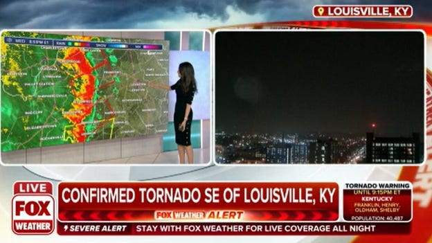
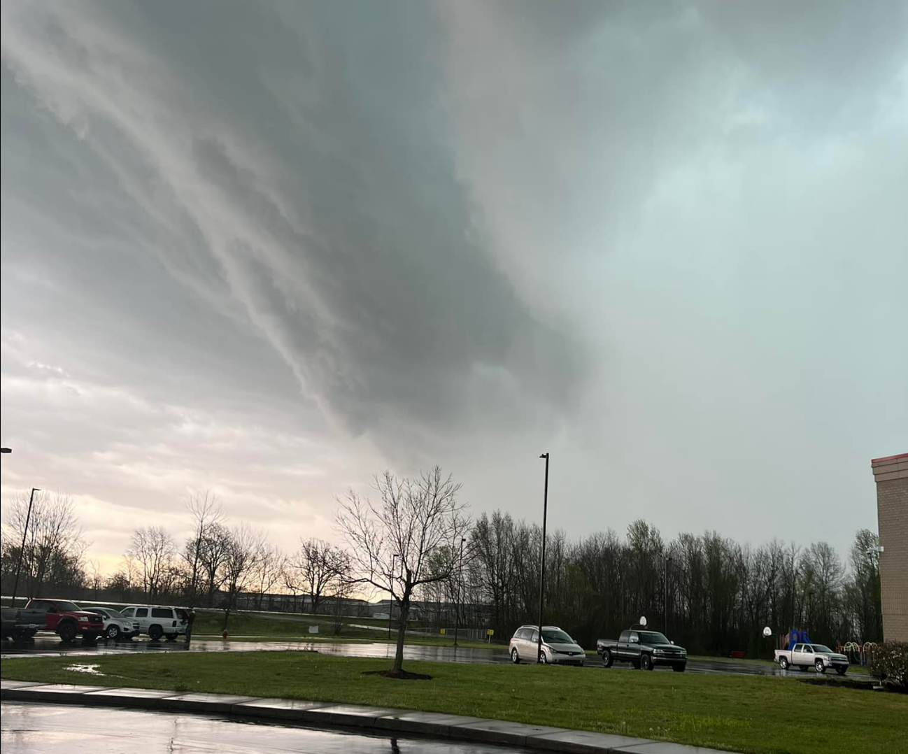
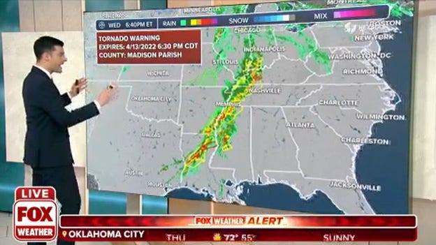
Several Tornado Warnings were issued east of Louisville on Wednesday. Authorities are still surveying damage from the storms. PowerOutage.US reported more than 57,000 outages in the Bluegrass State.
A Tornado Warning has been issued for Bibb, Hale and Tuscaloosa counties in Alabama until 11 p.m. CDT. Meteorologists are tracking a storm capable of producing a tornado that is moving through the central part of the state. If the storm holds together it could eventually threaten areas around Birmingham within the next hour.
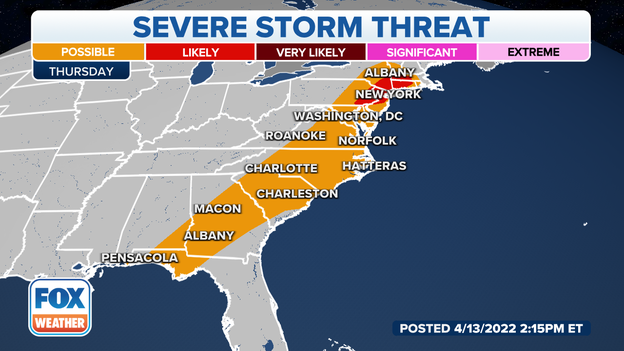
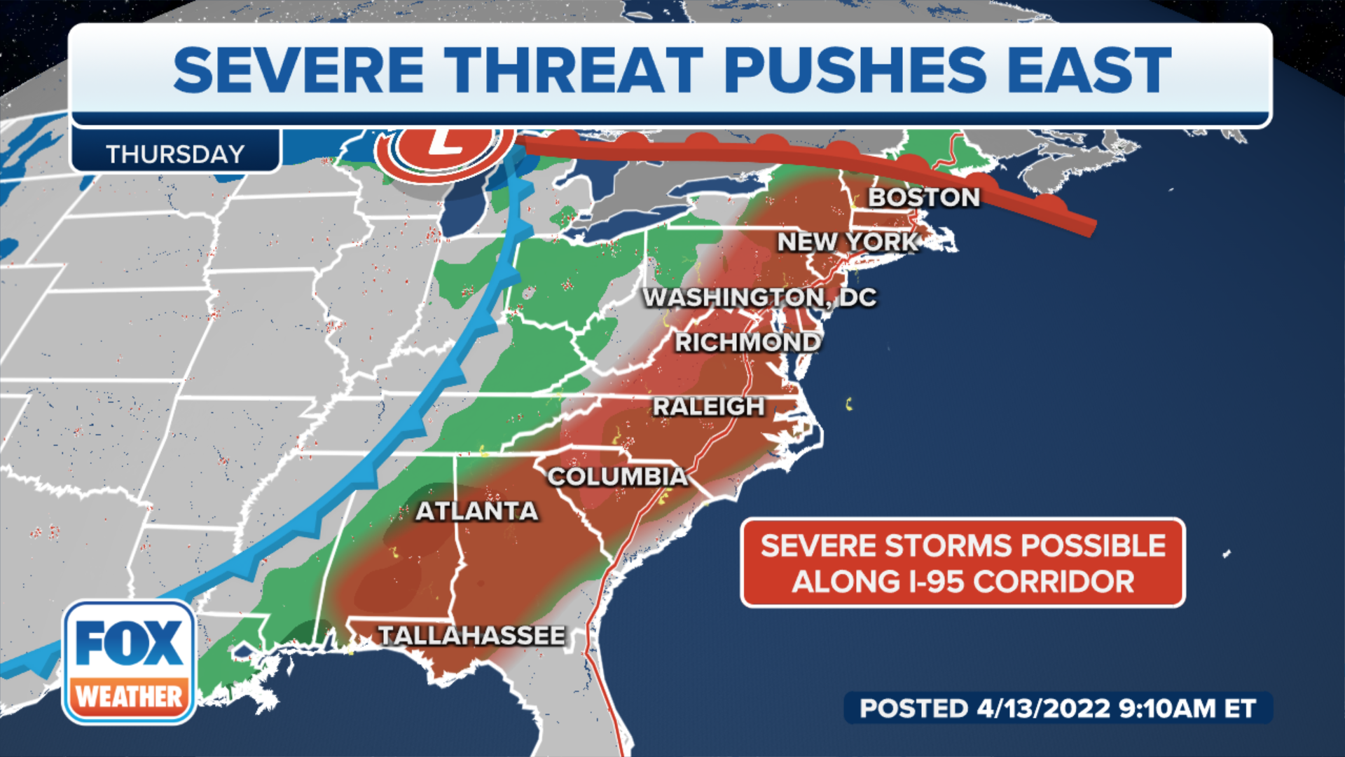
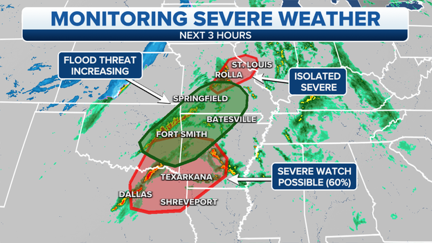
Thursday's forecast
Strong to severe storms will be possible along the I-95 corridor on Thursday as the storm system marches eastward. A widespread outbreak is not anticipated and the main threats appear to be gusty winds and hail.
Latest forecast: Click Here
Storms that rolled through Arkansas on Wednesday not only produced damaging winds and hail but also heavy rainfall. Areas of the state saw several inches of rain in a short time period causing creeks and rivers to rapidly rise.
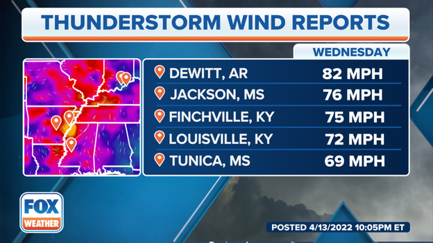
Top damage wind gusts
The highest winds gusts from Wednesday's storms topped hurricane strength from Arkansas and through the Ohio Valley. Another round of storms is expected to pop up on Thursday but the scope of the severe weather won't be as widespread.
FOX Weather 3D Radar
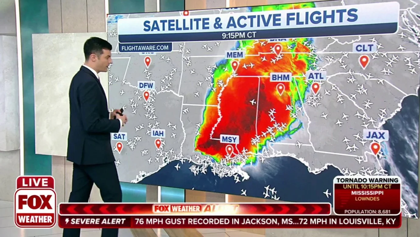
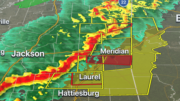
Several tornado-warned storms are along the I-59 corridor in Mississippi from Laurel to north of Meridian. The line of severe storms is pushing eastward and will enter Alabama within an hour.
Latest forecast: Click Here
FOX Weather 3D Radar
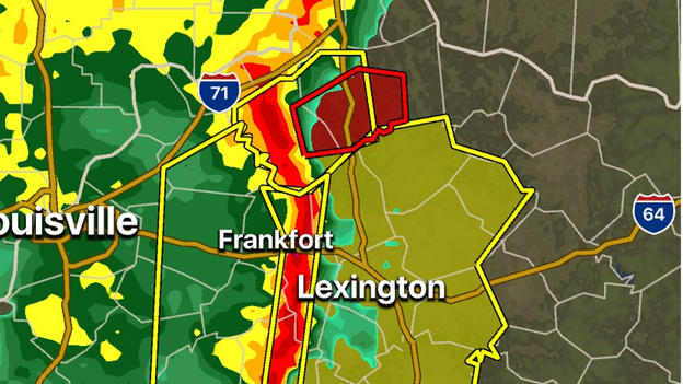
Several counties in the Bluegrass State are under a Tornado Warning as severe storms with the capability of producing a tornado move between Lexington and Cincinnati. The threat of tornadoes will diminish during the overnight hours.
Track the storms on the FOX Weather app: Download Now
Severe storms pushed through Nashville within the last hour and produced plenty of lightning and damaging winds.
Winds gusted to 64 mph at Nashville International Airport and 67 mph in Smyrna, Tennessee.
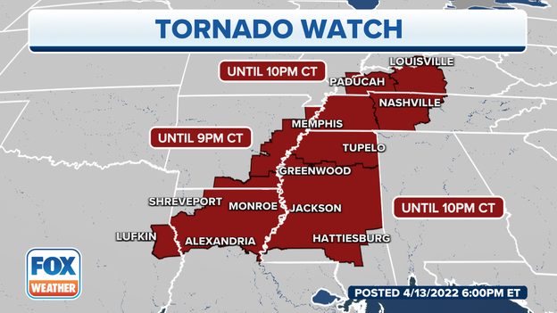
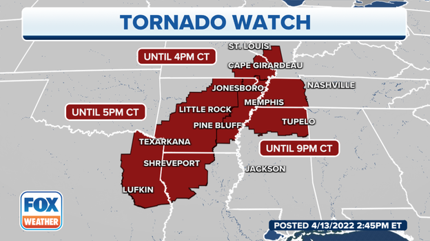
A Tornado Watch has been issued for parts of Louisiana and Mississippi through midnight because of the threat severe storms pose. Meteorologists are watching a line of storms with the threat of damaging winds and brief tornadoes.
Learn the difference between a watch and warning: Click Here
Tornado Warnings
The NWS issued a Tornado Warning for Mercer, Anderson, Marion and Washington Counties in Kentucky until 9:15 p.m., EDT. A radar indicated tornado was near Lebanon moving northeast at 65 mph,
Shelby, Oldham, Henry and Franklin Counties in Kentucky are under a Tornado Warning until 9:15 EDT.
Spencer, Shelby, Woodford, Anderson, Jefferson and Franklin Counties in Kentucky are under a Tornado Warning until 9 EDT.
Decatur County, Indiana is under a Tornado Warning until 9 EDT.
Severe storms with hail, damaging winds and tornadoes will continue through the night for parts of the South.
Latest forecast: Click Here
A severe storm capable of producing a tornado was over Byram, Mississippi moving east at 65 mph.
The NWS issued a Tornado Warning for Rankin and Hinds Counties until 8:15 p.m. CDT.
Oldham, Shelby and Jefferson Counties in Kentucky are under a Tornado Warning until 8:45 p.m. EDT due to a radar indicated tornado over Fern Creek moving northeast at 55 mph.
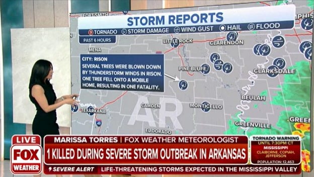
One fatality in Arkansas
An emergency manager in Rison, Arkansas reported that one person was killed when thunderstorm winds blew a tree onto a mobile home.
Tornado Warning
Claiborne, Jefferson and Copiah Counties in Mississippi and Tensas Parish, Louisiana are under a Tornado Warning until 7:30.
Radar indicated a tornado near Natchez, Mississippi moving east at 55 mph.
Kentucky Warnings
The NWS issued a Tornado Warning for Butler, Grayson and Ohio Counties in Kentucky until 7:00.
Radar indicated a tornado east of Hartford moving northeast at 60 mph.
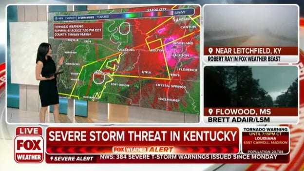
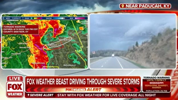
FOX Weather's Robert Ray is driving through the storms.
FOX Weather's Mitti Hicks cuts her report short to take shelter in Jackson.
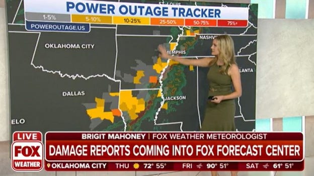
Power Outage Tracker
Almost 75,000 homes and businesses are without power right now, according to PowerOutage.US.
- Louisiana - 40,298
- Arkansas - 19,059
- Tennessee - 15,451
- Mississippi - 7,254
- Kentucky - 5,802
So far the NWS reports 122 tornados for April.
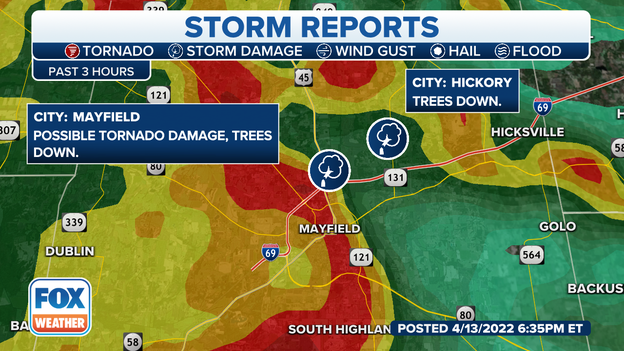
Possible tornado in Mayfield
Officials report trees down in Mayfield, Kentucky from a potential tornado. Mayfield is still rebuilding after a deadly EF-4 tornado hit in December.
MAYFIELD RECOVERY CONTINUES TWO MONTHS AFTER DEADLY TORNADO OUTBREAK
The NWS issued a Tornado Warning for Marshall, Tippah and Benton Counties in Mississippi until 6:30.
A severe thunderstorm capable of producing a tornado is over Holly Springs and moving east at 40 mph.
Warnings
A severe thunderstorm capable of producing a tornado was north of Hopkinsville, Kentucky moving northeast at 50 mph.
Muhlenberg, Christian and Todd Counties are under a Tornado Warning until 6:15.

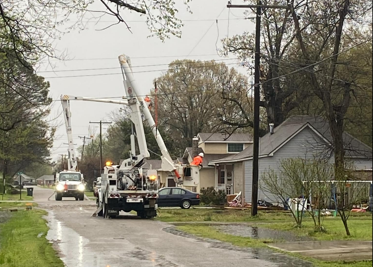
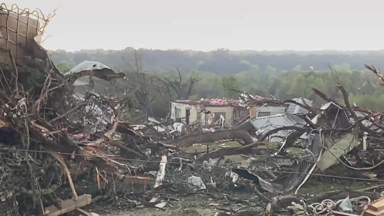
Mayfield, KY damage
Damage was reported in Mayfield after a severe storm moved through western Kentucky on Wednesday afternoon. The storm triggered a Tornado Warning because of radar indicated rotation in the storm.
The town is still in clean-up mode after a deadly EF-4 tornado destroyed hundreds of homes in December: Click Here
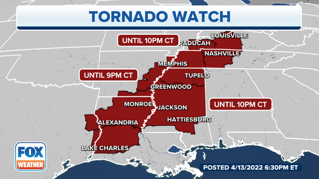
Tornado Watch
A new Tornado Watch for southwest to central Louisiana and southeast Texas is in effect until 10 p.m. CT.
Damaging winds with gusts up to 75 mph and isolated hail up to 1.5 inches are possible, according to the NWS Storm Prediction Center.
Tornadoes are not the only threat from this storm. The National Weather Service recently recorded hurricane-force winds in Arkansas:
- Hagler, Arkansas 82 mph
- Gracy, Kentucky 72 mph
- Tunica, Mississippi 70 mph
Active Tornado Watch for Indiana, Kentucky and Tennessee.
A new Tornado Watch is in effect until 10 p.m. CT for southern Indiana, West to Central Kentucky and Middle Tennessee.
The FAA has issued a ground stop at Chicago O'Hare due to thunderstorms in the area until 6:30 p.m. ET.
Hail reports are up this year after multiple rounds of Spring severe weather. More than 120 hail reports are from Texas where grapefruit-size hail came down on Tuesday.
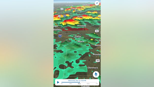
The Tornado Warning for Winnfield, Louisiana on the FOX Weather 3D radar.
The NWS has issued a Tornado Warning for Winnfield, Atlanta and Wheeling, Louisiana until 4:45 p.m. CT.
The strongest part of the storm will be over Winnfield by 4:30 p.m.
The western Kentucky town of Mayfield still recovering from a December tornado outbreak is under a Tornado Warning until 4:30 p.m. CT.
The warning also includes Dublin, Viola, Wingo and Fulton.
Tornado sirens are sounding off in Dyersburg, Tennessee as ominous clouds push into the area with a tornado-warned storm.
The NWS has issued Tornado Warnings for the following areas until 4:15 p.m. CT:
Louisiana: Haynesville, Summerfield, Colquitt, Pleasant Hill, Pelican and Benson
Tennessee: Martin, Union City, Tiptonville, Memphis, Bartlett
Rolling Tornado Warnings are being issued for western Kentucky.
The NWS has issued a Tornado Warning until 4:15 p.m. CT for areas including Fulton, Hickman, Carlisle counties in Kentucky and Southeast Mississippi County in Missouri.
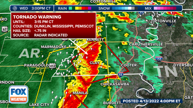
A Tornado Warning for Arkansas and Missouri.
The NWS in Memphis has issued a Tornado Warning for the following areas until 3:15 p.m. CT:
Southeast Green County, Arkansas
Northeast Craighead County, Arkansas
Northwest Mississippi County, Arkansas
Southwest Pemiscot County, Missouri
South Dunklin County, Missouri.
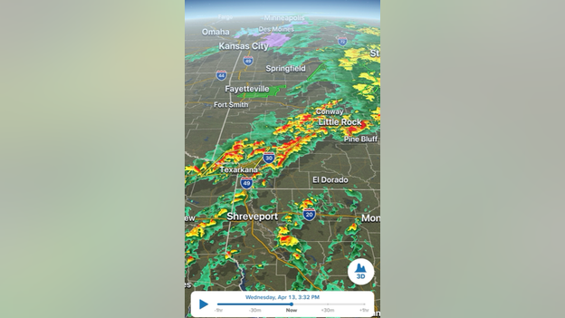
FOX Weather 3D radar at 2:30 p.m. CT
The NWS Office in Little Rock is now tracking the greatest severe threat across southeast Arkansas.
A severe Thunderstorm Warning continues for southwest Arkansas until 3 p.m. CT.
The Jackson Madison County Emergency Manager said the Tennessee community is still recovering from a recent tornado outbreak as it prepares for incoming severe weather once again.
This balloon with help the NOAA Severe Storms Laboratory with the PERiLS research project.
It will also help forecasters with today's severe weather threat.
For more information, click here.
Tornado Watches are in effect through Wednesday afternoon and evening
There are now seven states included in Tornado Watches through Wednesday afternoon and evening.
For more information about the storms, click here.
Incredible video shows major damage from a tornado in Salado, Texas on Tuesday.
For more information about the storms, click here.
Three additional tornadoes have been confirmed southwest and south of Riceville, Iowa, in Mitchell County and near the Howard County line
Two were EF-1 and one was EF-0.
To learn more about how tornadoes are rated, click here.
Severe weather is less likely because of excessive cloud cover.
For more information about the severe weather threat, click here.
The move will allow the state to better monitor storm activity and be better prepared to respond.
For more information about the severe weather, click here.
FOX Weather
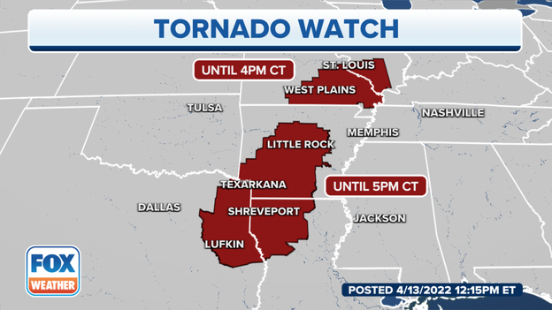
A Tornado Watch has been issued for parts of Illinois and Missouri until 4 p.m. CDT.
FOX Weather
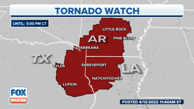
A Tornado Watch has been issued for parts of Arkansas, Louisiana and Texas until 5 p.m. CDT.
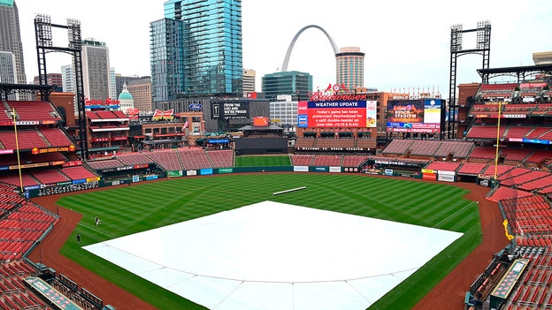
A general view of Busch Stadium after the game between the St. Louis Cardinals and the Pittsburgh Pirates was postponed due to rain at Busch Stadium on April 11, 2022 in St Louis, Missouri. The game has been rescheduled for a split double header on June 14th. (Joe Puetz/Getty Images)
The St. Louis Cardinals announced Wednesday that the 12:15 p.m. CDT game against the Kansas City Royals at Busch Stadium has been postponed due to inclement weather.
The National Weather Service in St. Louis said significant severe weather is expected Wednesday. The greatest risk is across east-central and southeast Missouri and southern Illinois.
The two teams will make up the game on Monday, May 2, at 3:15 p.m. at Busch Stadium.
Tickets for the postponed homestand finale will be valid for the rescheduled game.
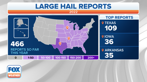
There were 126 reports of hail Tuesday. It was the single-highest day so far this year and accounted for 26% of the year's total hail (466 reports). Click here for more.
Click on image above to watch video.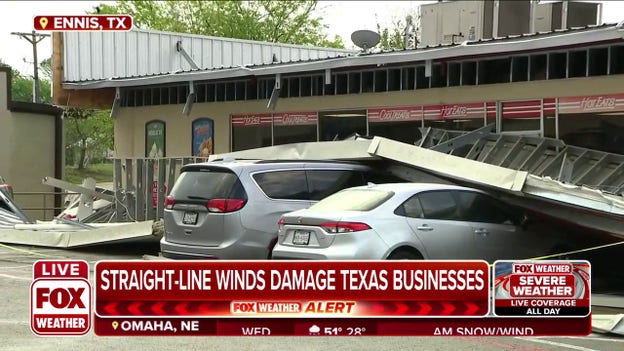
Communities in Texas are dealing with damage to their homes and businesses after intense storms swept through south of Dallas in Ellis County. FOX 4 Dallas reporter Dan Godwin is in Ennis, Texas, with the latest.
Click on image above to watch video.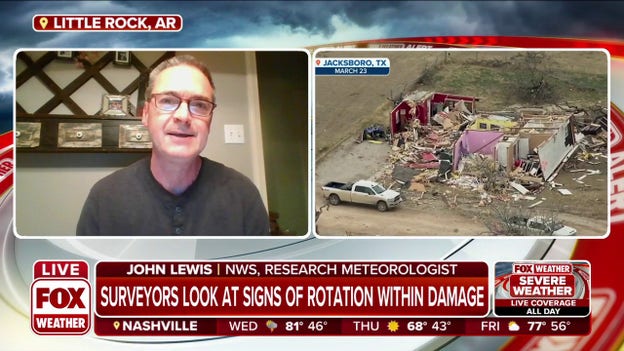
John Lewis, a research meteorologist at National Severe Storms Laboratory and National Weather Service, explains what they look for surveying tornado damage.
Click on image above to watch video.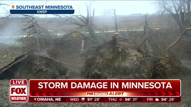
Severe storms left extensive damage in southeast Minnesota on Tuesday. Click here to watch latest video.
FOX Weather
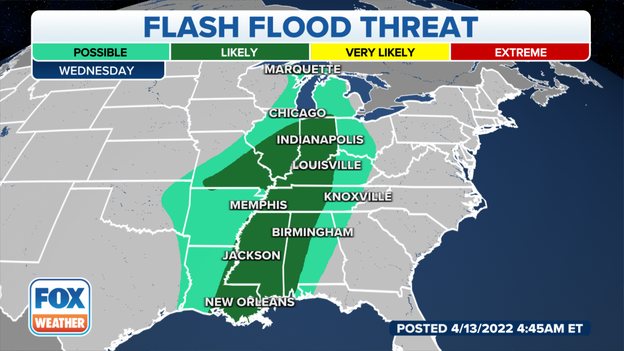
High atmospheric moisture values will create an environment conducive for thunderstorms to contain high rainfall rates, posing a risk of flash flooding.
FOX Weather
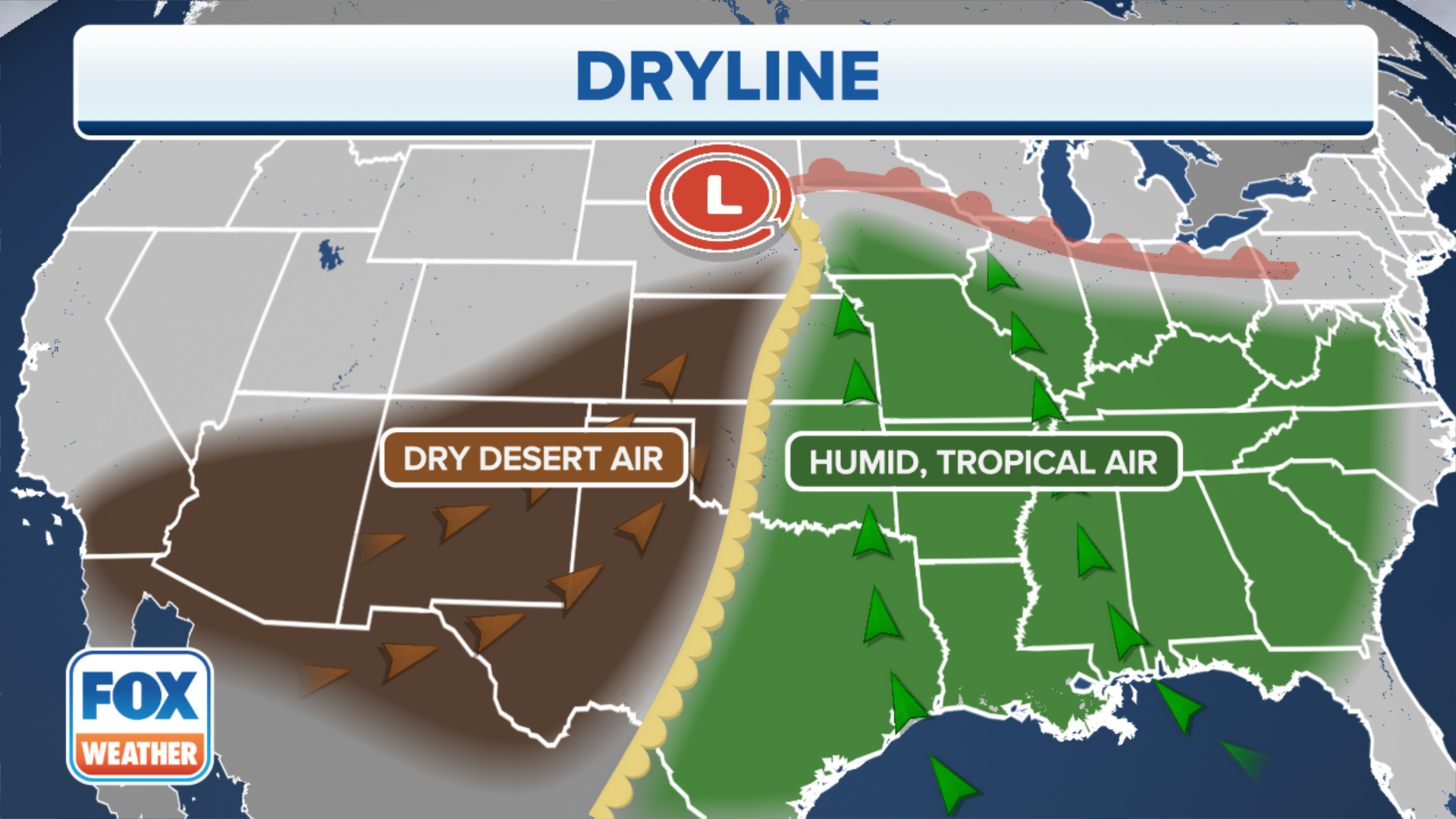
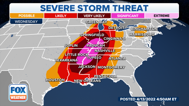
A severe thunderstorm outbreak is expected Wednesday into Wednesday night across a large area from the lower and mid-Mississippi Valley northward to the mid-South and Midwest.
Several tornadoes, widespread destructive winds – including some gusts over 75 mph – and large hail greater than 2 inches in diameter are all significant threats. Some of the tornadoes could be EF-2 or stronger, particularly in parts of the mid-South region.
Most of the severe weather will be in the form of a squall line tracking eastward across these regions, but supercells could also develop out ahead of the main line of storms.
A few severe thunderstorms are also possible mid- to late Wednesday afternoon into Wednesday evening from central and northeastern Pennsylvania to central New York. Strong wind gusts and hail are the main risks in this area.

FOX Weather
A severe storm outbreak is expected Wednesday. NOAA's Storm Prediction Center said widespread severe storms are likely across a very broad north-south region from the lower Mississippi Valley and mid-South into the Midwest. Atmospheric ingredients are favorable for all severe hazards, including several tornadoes, widespread damaging winds and large hail.
You’ve reached the beginning of this live coverage.