What US county is most impacted by hurricanes?
Key West is home to the southernmost point in the continental United States. The chain of 1,700 islands is situated where the Atlantic Ocean, Gulf of Mexico and Florida Bay meet. The conglomeration of warm water is beneficial for strengthening tropical storms and hurricanes. The State of Florida estimated Monroe County has a population of around 85,000, but millions of tourists visit the islands every year.

Ian, Fiona retired from hurricane naming lists
The World Meteorological Organization removed the names Fiona and Ian from rotation due to the death and destruction they caused during the 2022 hurricane season.
The southernmost point in the continental United States is the destination for millions of vacationers, but because of its location, the island paradise is one of the regions most impacted by hurricanes.
Monroe County, Florida, is home to the popular Key West as well as hundreds of other islands that make up the Florida Keys.
According to NOAA historical data, 117 cyclones since the 1800s have passed within 50 miles, making the region the most impacted area of the country from tropical trouble.
Since the islands sit at the convergence of the Gulf of Mexico, Atlantic Ocean and Florida Straits, there is always plenty of warm water around that can aid in tropical cyclone development.

117 tropical storms and hurricanes have passed within 50 miles of Monroe County, Florida
(NOAA)
According to an analysis by the National Weather Service, impacts from hurricanes are more frequent than tropical storms, which could be a reflection of how conducive conditions are for tropical cyclone development around southern Florida.
Impacts from stronger hurricanes are most common during September and October, which are considered peak months for formations.
Hurricane experts contend that the distribution of cyclones from the Gulf of Mexico and Atlantic does not favor one waterway over another, meaning both have about even odds for producing threats.
The NWS estimates that since 1871, around 54% of hurricanes that impact the islands move out of the Caribbean Sea into the Gulf of Mexico or travel over Cuba.
The Outer Banks in North Carolina rank just behind the Florida Keys in terms of the number of tropical storms and hurricanes passing within 50 miles.
According to the NOAA historical data, Hyde County, North Carolina, has seen 116 cyclones pass close by, while neighboring Dare County follows closely behind with 111 cyclones.
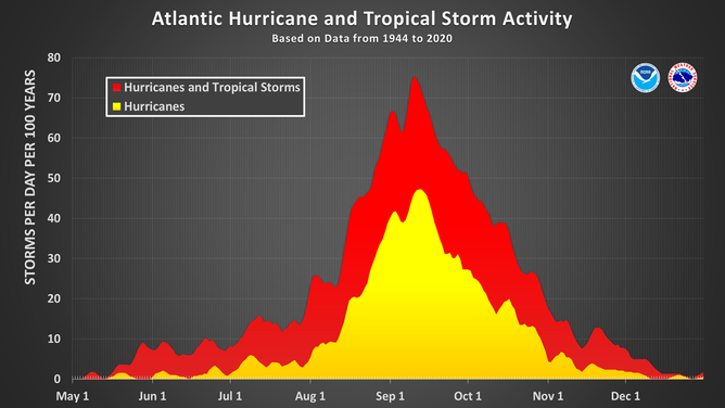
This chart shows the amount of tropical cyclone activity, in terms of named storms and hurricanes, that occurs in the Atlantic Basin on each calendar day between May 1 and Dec. 31. Specifically, it shows the number of hurricanes (yellow area) and the combined named storms and hurricanes (red area) that occur on each calendar day over a 100-year period. The chart is based on data from the 77-year period from 1944 to 2020 (starting at the beginning of the aircraft reconnaissance era) but normalized to 100 years. The official hurricane season for the Atlantic Basin is from June 1 to Nov. 30, but tropical cyclone activity sometimes occurs before and after these dates, respectively. The peak of the Atlantic hurricane season is Sept. 10, with most activity occurring between mid-August and mid-October.
(National Hurricane Center / NOAA)
What was the last hurricane to make landfall in the Keys?
The last hurricane to make a direct landfall in Monroe County, Florida, was Hurricane Ian in 2022.
At the time, the hurricane was a Category 3 with maximum sustained winds of around 125 mph but strengthened into a Category 5 in the hours after.
The center of the storm traveled over the Dry Tortugas, which is a group of seven small islands about 70 miles west of Key West.
Dry Tortugas National Park is only accessible by boat or plane and is operated by the National Park Service.
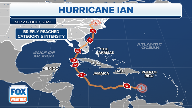
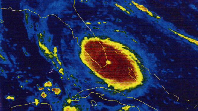
The track and intensity of Hurricane Ian in September 2022.
(FOX Weather)
Due to Ian being a compact storm, only tropical storm conditions were reported in the Lower Keys; however, a storm surge of upwards of five feet submerged streets and flooded homes.
Of the 149 deaths reported statewide, at least seven occurred in and around Monroe County.
According to local officials, a boat with Cuban migrants was caught in the storm, causing the high fatality count.
BEWARE OF THE ‘I’ STORM: IT HAS MORE RETIREES THAN ANY LETTER USED FOR ATLANTIC HURRICANE NAMES
Other memorable hurricanes
2017- Hurricane Irma
Irma struck the Florida Keys as a Category 4 hurricane with sustained winds greater than 130 mph.
Due to its unusual path from the south, the Lower and Middle Keys were the hardest-hit areas.
The storm’s eye traveled over Cudjoe Key, and a storm surge of 9 feet was reported.
The Monroe County Medical Examiner reported three victims drowned during the hurricane and another 14 people died due to weather-related causes.
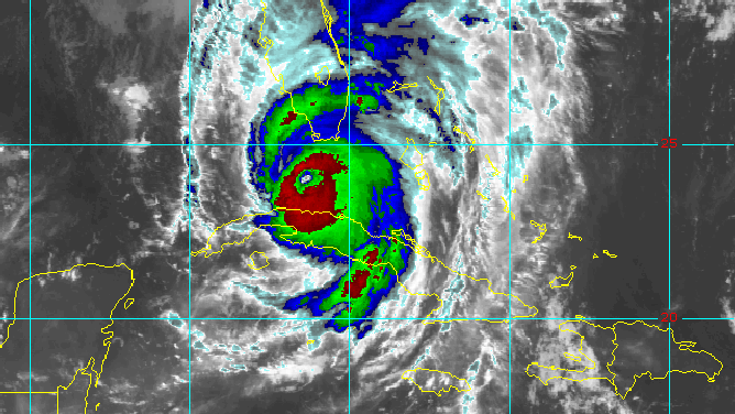
Hurricane Irma satellite loop from Sept. 10, 2017
(NOAA)
2005- Hurricane Wilma
While the center of the hurricane was over 75 miles to the northwest of the Keys, the region was still buffeted by strong winds and a storm surge that reached at least 8 feet.
The local National Weather Service office reports no fatalities occurred during the storm, but one person was killed during pre-storm evacuations.
The storm surge flooding was considered to be the worst to impact the Keys since Hurricane Betsy in September 1965.
Damage in Monroe County was estimated to be more than $200 million.
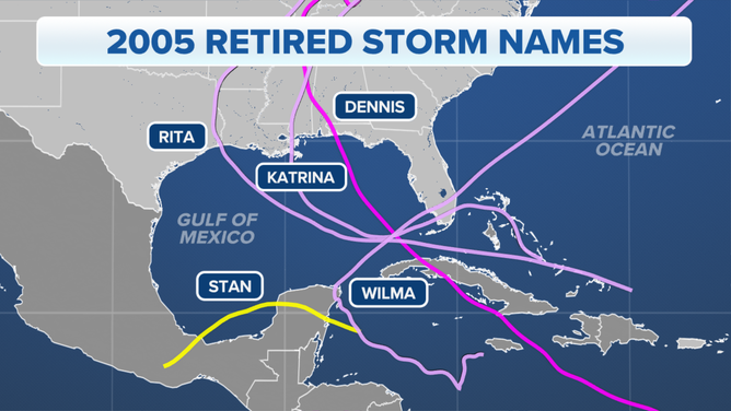
The tracks of 2005's five retired hurricanes: Dennis, Katrina, Rita, Stan and Wilma.
(FOX Weather)
1999 – Hurricane Irene
Irene’s winds were more significant in the Florida Keys than storm surge flooding. Despite Irene being a Category 1 hurricane, an observation site reported a wind gust of 102 mph in Big Pine Key.
Significant power outages were reported, and locals said the cyclone’s eye passed over Key West.
1992 - Hurricane Andrew
The Category 5 hurricane was a narrow storm, which meant damage was primarily limited to the Upper Keys.
Key Largo reported a sustained wind of 114 mph while gusts only reached tropical storm strength in the Lower Keys.
Damage was estimated to be at $120 million to homes and buildings, $10 million to the marine industry and $1 million to the fishing industry.
Satellite image of Hurricane Andrew at landfall.
(NOAA)
1965 - Hurricane Betsy
Betsy was a major Category 3 hurricane when it crossed through the Keys, causing severe damage.
Key West reported maximum sustained winds of 81 mph, while Tavernier reported a maximum sustained wind of 120 mph.
The NWS reported Key Largo saw a storm surge of at least 9’ and 11.80" of rain fell over Plantation Keys.
Locals recall being in the storm’s large eye between 2 and 3 hours.
1935 - Great Labor Day Hurricane
The strongest hurricane ever to make landfall in the U.S. did so in the Florida Keys.
Sustained winds were estimated to have been around 185 mph with over 200 mph gusts.
According to Monroe County historical records, over 400 residents and bridge workers lost their lives.
The storm caused devastation from Long Key to Plantation Key and cut off transportation for years.
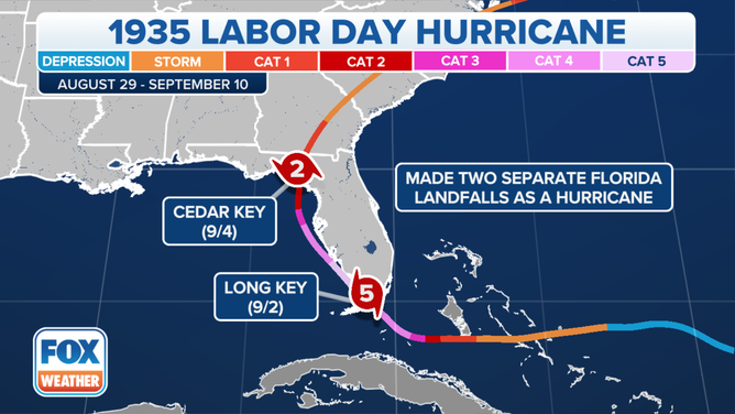
The track of the 1935 Labor Day Hurricane.
(FOX Weather)