Analysis: Typhoon Mawar's last-minute swerve spared Guam even worse winds
Videos emerging from the storm's aftermath after daylight broke Thursday morning showed extensive damage to the island, but analysis of the storm's approach shows Mawar underwent some last-minute changes that likely spared the island from an even worse assault.

Typhoon Mawar leaves Guam with widespread damage after US territory lashed with destructive winds
Super Typhoon Mawar is continuing to strengthen as it continues to spin away from the U.S. territory of Guam after lashing the island with winds stronger than 100 mph on Wednesday.
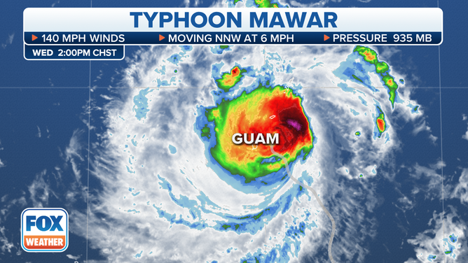
HAGATNA, Guam – Typhoon Mawar slammed into Guam on Wednesday, lashing the US territory with gusts over 100 mph amid torrential rains and pounding surf.
Videos emerging from the storm's aftermath after daylight broke Thursday morning showed extensive damage to the island, but analysis of the storm's approach shows Mawar underwent some last-minute changes that likely spared the island from an even worse assault.
Typhoon Mawar weakened on approach due to eyewall replacement cycle
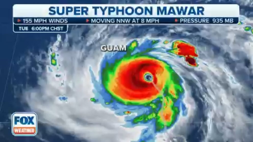
As Mawar churned toward the island Tuesday evening with estimated peak sustained winds of 155 mph, a strong, concentric eye was notable on satellite imagery – a testament to the storm's strength.

(FOX Weather)
However, early Wednesday morning, the eye appeared to collapse for several hours. This was likely due to what's known as an "eyewall replacement cycle." This is a common phenomenon with strong hurricanes and typhoons as they churn along in their complex atmospheric swirl of activity.
5 DIFFERENT NAMES FOR HURRICANES AROUND THE WORLD
A new eyewall begins to form on the outside of the previous inner eyewall, cutting off the fuel for the inner wall and eventually leading to its demise.
The result is a new eyewall that is larger in radius but temporarily weaker in intensity, leading to a drop in the storm's peak winds. Eventually, the new eyewall could rev back up and become more concise and powerful and the storm regains strength. These cycles can happen multiple times on a tropical system's journey.
(FOX Weather)
In Mawar's case, the ERC happened in the hours before the storm made its closest pass to the island, meaning the typhoon's peak winds were likely a lot lower – though still well above damaging speeds – than they would have been had the ERC not taken place. Radar analysis would later indicate wind gusts were around 100-110 mph as the typhoon passed near the shore.
Typhoon Mawar took a jog to the right
Another fortuitous event was a last-minute swerve in Mawar's path. On Wednesday morning, it appeared Mawar was going to make a direct strike into the heart of Guam. The storm instead made a sharp turn to the right in the hours before impact – likely related to the ongoing eyewall replacement cycle – then eventually curved back left with the potent center of the storm instead passing just off the island's northern shores.
Satellite history of Typhoon Mawar as it passed by Guam
Watch as Typhoon Mawar weakens and makes a critical jog in its path just before it strikes Guam on Wednesday.
The typhoon still brought severe impacts to the northern island as the eyewall scraped the shores, but the change in path likely kept most of the eyewall's highest gusts over open water instead of unleashing its entire wrath on the island.
The more northerly track also meant the island stayed on the south side of the storm, mitigating the severe storm surge that would have come with the extreme onshore winds of the northern side of the eyewall. As of Thursday evening in Guam, there have been no reports of serious injuries or deaths, according to government officials.
WHAT DOES IT MEAN WHEN A HURRICANE UNDERGOES ‘RAPID INTENSIFICATION’?
"With no hostile atmospheric conditions in place around Mawar to weaken it, the only thing that could have prevented far worse impacts in Guam was an eyewall replacement cycle, and one wound up occurring at the exact perfect time," said FOX Weather meteorologist and senior weather producer Greg Diamond. "This really was the best case of a worst-case scenario."
Typhoon Mawar regained strength later
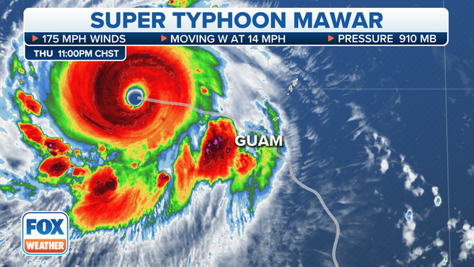
As if to illustrate the point, the storm restrengthened just hours after it passed Guam as the eyewall regenerated Thursday afternoon.
By Thursday night in Guam, the typhoon once again became a super typhoon with a much larger eyewall and estimated peak sustained wind speeds of 175 mph.
(FOX Weather)
Mawar now ranks as the strongest typhoon or tropical system measured on the planet so far this year.