Regional tornado outbreak spawned at least 11 twisters in Alabama, Mississippi over the weekend
Tornado Watches had been in effect when the storms moved inland from the Gulf of Mexico and into areas near Biloxi and Hattiesburg in Mississippi and the Mobile, Alabama, metro area.
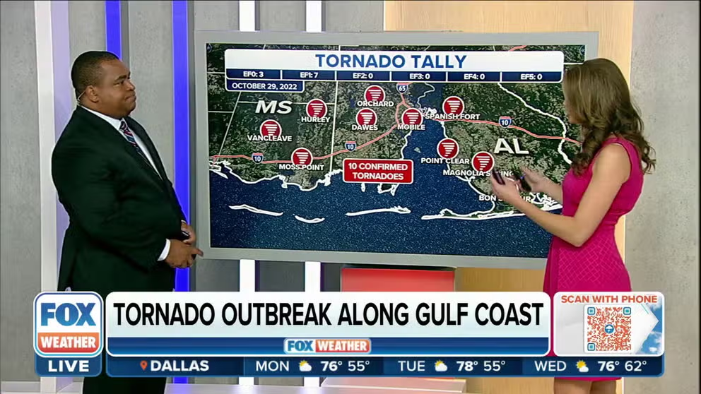
NWS confirms 10 tornadoes occurred Saturday with regional outbreak in Mississippi, Alabama
Damage surveys completed so far from the NWS confirm 10 tornadoes did occur across Southern Mississippi and Alabama Saturday.
Survey teams with the National Weather Service have confirmed at least 11 tornadoes struck southeastern Alabama, southwestern Mississippi and central Louisiana after a storm system moved through the central Gulf Coast region on Saturday.
Tornado Watches had been in effect when the storms moved inland from the Gulf of Mexico and into areas near Biloxi and Hattiesburg in Mississippi and the Mobile, Alabama, metro area.
The FOX Forecast Center is calling this event a regional tornado outbreak sparked by an unusually high amount of wind shear – the change in wind speed and direction with height – that combined with moisture from the Gulf of Mexico.
The same low-pressure system will slide eastward Monday and Tuesday, and that could lead to an unsettled Halloween from the Great Lakes and Ohio Valley to parts of the East Coast.
Map showing the 10 confirmed tornadoes across southeastern Mississippi and southwestern Alabama on Saturday, Oct. 29, 2022.
(FOX Weather)
All of the tornados touched down closer to the Gulf Coast in Mississippi and Alabama, with most of the touchdowns occurring in Alabama.
Three of those tornadoes were rated an EF-0 on the Enhanced Fujita Scale, seven were rated EF-1, and one was rated EF-2.
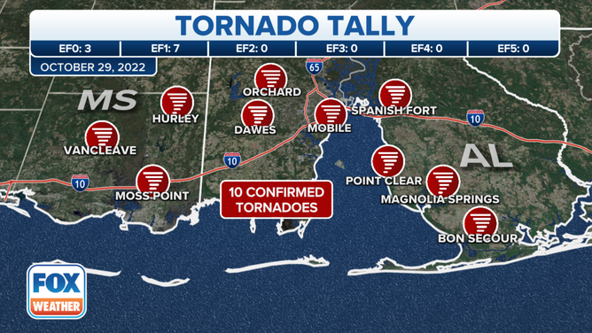
A tornado in Moss Point, Mississippi, was rated an EF-1 with winds of 107 mph.
(FOX Weather)
One of the tornadoes that touched down was located in the community of Moss Point, Mississippi.
Survey teams with the National Weather Service said the tornado was rated EF-1 with winds of 107 mph.
It touched down around 3:20 p.m. Central and was on the ground for about 2.8 miles before dissipating around 3:27 p.m. Central.
That tornado was about 250 yards wide.
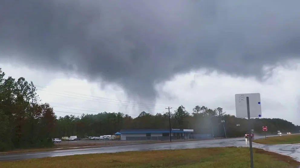
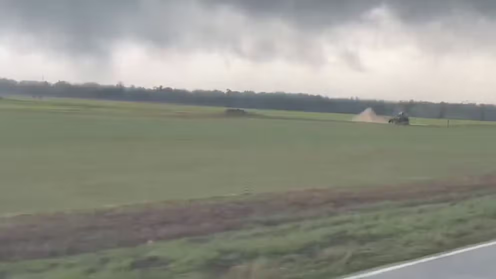
Video shows tornado crossing I-10 near Moss Point, Mississippi
A video shows a tornado crossing Interstate 10 near Moss Point, Mississippi, on Saturday when severe weather moved through the region.
A video showed the tornado crossing Interstate 10 near Moss Point, and it caused damage to at least one vehicle and a building.
The video also showed the tornado spinning over a bridge before moving farther inland.
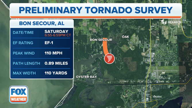
A tornado that touched down near Bon Secour, Alabama, was rated an EF-1 with winds of 110 mph.
(FOX Weather)
Another EF-1 tornado touched down near the community of Bon Secour, Alabama, on Saturday evening.
That tornado had winds of 110 mph and touched down around 6:55 p.m. Central.
It was on the ground for just under a mile when it finally dissipated four minutes later at 6:59 p.m. Central.
Tornado spotted in southern Alabama
`A tornado was spotted in Magnolia Springs, Alabama on Saturday afternoon.
Matt Magiera was south of Mobile in the town of Magnolia Springs, Alabama, when he spotted a tornado and took video of the event.
The twister appeared to damage power lines before crossing through a farm field.

Mobile Bay waterspout
(Ross Dorsett)
Ross Dorsett captured a similar sight in southern Alabama and took a photo of a waterspout traveling up Mobile Bay.
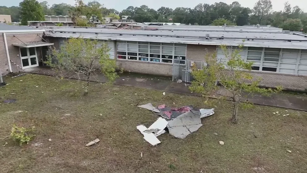
Drone video shows damage to Mississippi middle school after tornadoes move through region
A drone video shows the damage to a Gautier Middle School in Gautier, Mississippi, after tornadoes moved through the region on Saturday.
Drone video taken after the storms moved through shows damage left behind at Gautier Middle School in Gautier, Mississippi.
The video shows debris littering the ground and damage spotted on the roof of the building.
The strongest tornado, EF-2, started near the Calcasieu river near Oberlin, Louisiana and traveled less than half a mile. In that time, peak winds hit 111 pm which blew a tree onto a manufactured home and tore off an awning. Another carport fell into a car and the wind pushed a fully loaded construction trailer 6 feet.
HOW METEOROLOGISTS DETERMINE IF A TORNADO IS TO BLAME FOR STORM DAMAGE
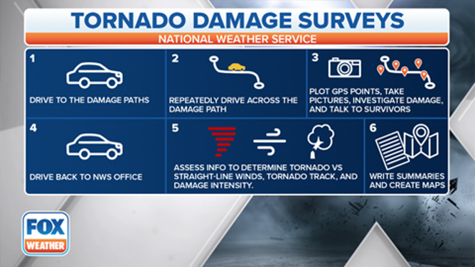
A graphic showing how the National Weather Service investigates tornado damage.
(FOX Weather)
Severe weather in the South is not unusual during the autumn. Fall is often considered the second severe weather season because it's the time of year when warm, humid air from the Gulf of Mexico starts to clash, with colder air beginning to infiltrate the U.S. from Canada as winter inches closer.
In addition to the severe weather, some communities received heavy rainfall that occurred during a short period of time.