Saharan dust continues to hamper hurricane, tropical storm development in Atlantic as August begins
Satellite imagery detected the dusty air over portions of the Gulf of Mexico on Thursday, and it's forecast to push into parts of South Florida and the Gulf Coast as far west as Texas late this week and into the weekend
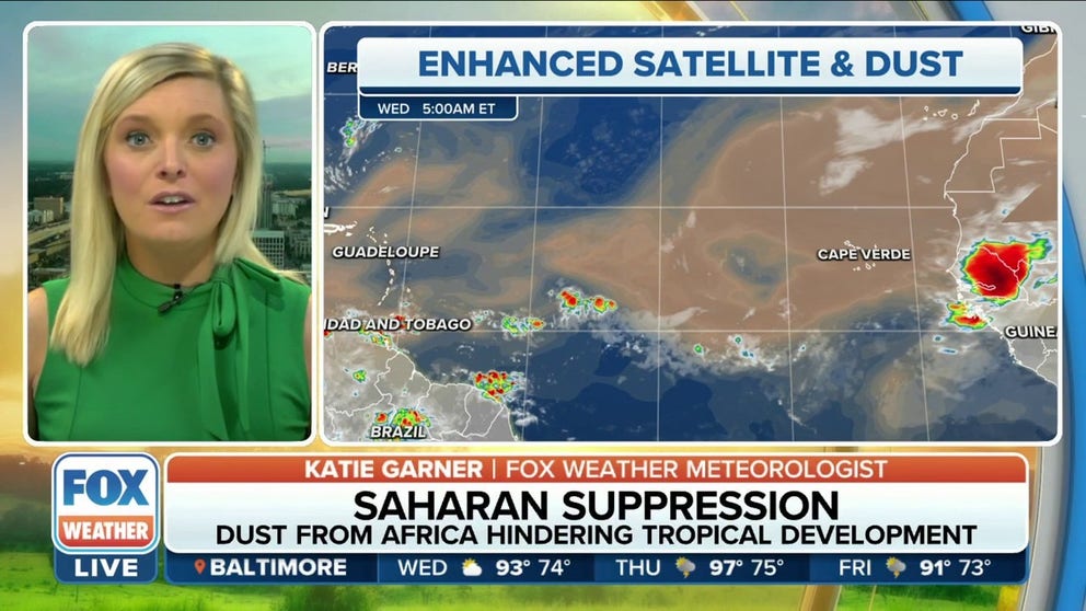
Saharan dust from Africa hindering tropical development in the Atlantic
Saharan dust from Africa is hindering hurricane and any tropical development in the Atlantic these last couple of weeks.
A plume of dust and dry air from the Sahara Desert in Africa is stretching thousands of miles across the Atlantic this week, helping to continue the hurricane season's month-long slumber.
This mass of very dry, dusty air is called the Saharan Air Layer. According to the National Oceanic and Atmospheric Administration's Atlantic Oceanographic and Meteorological Laboratory, it forms over the Sahara Desert during the late spring, summer and early fall and moves into the tropical Atlantic every three to five days.
Saharan Air Layer activity typically ramps in mid-June, peaks between late June and mid-August, then quickly subsides after mid-August. During this peak period, Saharan dust plumes will often travel all the way to Florida and the U.S. Gulf Coast, including as far west as Texas – a journey of more than 5,000 miles.
5 THINGS TO KNOW ABOUT THE SAHARAN DUST PLUME
According to NOAA, the dust plume is usually 2 to 2.5 miles thick, with its base situated about 1 mile above the Earth's surface, so that means it generally sits between 5,000 and 20,000 feet above ground level.
A ribbon of stronger winds in the mid-levels of the atmosphere called the African easterly jet stream transports the dust from Africa westward across the Atlantic Ocean. Then, a high-pressure system in the subtropical Atlantic can send the dust into the Caribbean. From there, the wind patterns can steer the dust toward parts of the U.S.
Satellite imagery detected the dusty air over portions of the Gulf of Mexico on Thursday, and it's forecast to push into parts of South Florida and the Gulf Coast as far west as Texas late this week and into the weekend.

(FOX Weather)
HOW TO WATCH FOX WEATHER ON TV
Saharan dust is notorious for creating vibrant sunrises and sunsets because it taps into the color spectrum as the light bounces off dust particles.
A keen observer in Corpus Christi, Texas, noticed some dust in the sky last weekend as the sun began to set and skies turned a vibrant pink color.
The dust can also contribute to poor air quality in some areas.
WHEEZING AND SNIFFLING? IT COULD BE SAHARAN DUST
According to NOAA, the Saharan dust plume has been shown to suppress tropical storm and hurricane formation and intensification in the Atlantic.
The dusty air is very dry, with about 50% less moisture than the typical tropical atmosphere. This extremely dry air creates downdrafts of sinking air around a tropical cyclone or one trying to develop, which can weaken the system.
Additionally, strong winds are associated with the Saharan dust plume at a typical height of 6,500 to 14,500 feet above the Earth's surface. These winds can significantly increase the vertical wind shear – the change in wind speed and/or direction with height – which creates a hostile environment for the formation of tropical storms and hurricanes.
The Saharan Air Layer's warmth also acts to stabilize the atmosphere, which can suppress the development of clouds that are needed for tropical cyclones to develop and grow.
CLICK HERE TO GET THE FOX WEATHER UPDATE PODCAST

(FOX Weather)
Although we're now entering the peak of the Atlantic hurricane season, meteorologists expect the lull in hurricane and tropical storm activity to continue at least through the first week of August. Ongoing Saharan dust plumes emerging from the coast of Africa are one of the many factors that have led to the hurricane season appearing benign in recent weeks.
HURRICANE FORECASTERS AT COLORADO STATE, NOAA REAFFIRM CONFIDENCE IN BUSY SEASON PREDICTION
Computer forecast models suggest off and on dust plumes will impact parts of South Florida, Texas and other areas along the Gulf Coast for the near-term future as they continue to work their way from west to east across the Atlantic.